
FCCInfo.com
A Service of Cavell, Mertz & Associates, Inc.
(855) FCC-INFO
|
|
K261DP from 11/06/1997 |
|
|
||||||||||||||||
|
|
K261DP Channel: 261D 100.1 MHz Oklahoma City, Oklahoma Service: FX - A translator or application for a translator. Facility ID: 83195 Fac. Service: FX Programming Delivery Method: Unspecified Status: License Application Accepted: 07/15/2021 Application Granted: 08/05/2021 File Number: -0000152881 License Expires: 06/01/2028 Application Type: License To Cover FCC Website Links: LMS Facility Details This Application Other K261DP Applications Other K261DP Applications in CDBS Including Superseded Applications Mailing Address Correspondence for K261DP Correspondence related to application -0000152881 Service Contour - Open Street Map or USGS Map (60 dBu) Service Contour - KML / Google Earth (60 dBu) Facility Type: NON-COMMERCIAL EDUC. FM Class: D, A Noncommercial educational operating with no more than 10W Site Location: 35-34-07.0 N 97-29-21.0 W (NAD 83) Site Location: 35-34-06.8 N 97-29-19.9 W (Converted to NAD 27) Effective Radiated Power: 0.099 kW Transmitter Output Power: 0.174 kW Antenna Center HAAT: 133.7 m Horiz.; 0 m Vert. Antenna Center AMSL: 709.6 m (2328 ft.) Antenna Center HAG: 360 m (1181 ft.) Site Elevation: 349.6 m. (1147 ft.) Height Overall*: 488.3 m (1602 ft.) (* As Filed In This Application, may differ from ASR Data, Below.) Directional Antenna Antenna Make/Model: Nicom BKG77 Antenna ID: 90289 Polarization: H
| ||||||||||||||||||
| Antenna Data for Antenna Id: 90289 K261DP FX File: -0000152881 Nicom - BKG77 Service: FX | 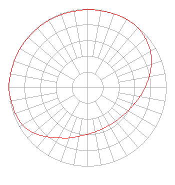 | ||||||||||||||||||
| Azimuth | Ratio | Azimuth | Ratio | Azimuth | Ratio | Azimuth | Ratio | ||||||||||||
| 0 | 0.988 | 10 | 0.988 | 20 | 0.992 | 30 | 1.000 | ||||||||||||
| 40 | 0.991 | 50 | 0.963 | 60 | 0.923 | 70 | 0.862 | ||||||||||||
| 80 | 0.797 | 90 | 0.731 | 100 | 0.676 | 110 | 0.628 | ||||||||||||
| 120 | 0.594 | 130 | 0.571 | 140 | 0.558 | 150 | 0.553 | ||||||||||||
| 160 | 0.558 | 170 | 0.571 | 180 | 0.594 | 190 | 0.628 | ||||||||||||
| 200 | 0.682 | 210 | 0.738 | 220 | 0.815 | 230 | 0.897 | ||||||||||||
| 240 | 0.953 | 250 | 0.973 | 260 | 0.983 | 270 | 1.000 | ||||||||||||
| 280 | 0.992 | 290 | 0.988 | 300 | 0.988 | 310 | 0.983 | ||||||||||||
| 320 | 0.983 | 330 | 0.983 | 340 | 0.983 | 350 | 0.983 | ||||||||||||
Structure Registration Number 1043710 Structure Type: TOWER Registered To: Tribune Broadcasting Company II, LLC Structure Address: 1401 E. Britton Rd Oklahoma City, OK County Name: Oklahoma County ASR Issued: 01/16/2020 Date Built: 04/06/1965 Site Elevation: 349.6 m (1147 ft.) Structure Height: 459.9 m (1509 ft.) Height Overall: 488.3 m (1602 ft.) Overall Height AMSL: 837.9 m (2749 ft.) Paint & Light FAA Chapters: 1, 3, 10.1, 19.1, 21 35-34-07.0 N 97-29-21.0 W (NAD 83) 35-34-06.8 N 97-29-19.9 W (Converted to NAD 27) |
Ponca City, OK 74602 Phone: 580-401-8888 Not-for-Profit | Title: President Date: 07/15/2021 Application Certifier THE LOVE STATION, INC. The Love Station, Inc. Ponca City, OK 74602 Applicant Doyle Brewer The Love Station, Inc. Ponca City, OK 74602 President Gene Wisniewski World Radio Link, Inc. Twin Falls, ID 83303 CONSULTING ENGINEER | |||||||||||||||||