
FCCInfo.com
A Service of Cavell, Mertz & Associates, Inc.
(855) FCC-INFO
|
|
|
|
|
||||||||||||||||
|
|
W276DM Channel: 276D 103.1 MHz Auburn, Indiana Service: FX - A translator or application for a translator. Facility ID: 201732 Fac. Service: FX Programming Delivery Method: Unspecified Status: License Application Accepted: 07/30/2021 Application Granted: 09/15/2021 File Number: -0000155078 License Expires: 08/01/2028 Application Type: License To Cover FCC Website Links: LMS Facility Details This Application Other W276DM Applications Other W276DM Applications in CDBS Including Superseded Applications Mailing Address Correspondence for W276DM Correspondence related to application -0000155078 Service Contour - Open Street Map or USGS Map (60 dBu) Service Contour - KML / Google Earth (60 dBu) Facility Type: FM STATION Class: D, A Noncommercial educational operating with no more than 10W Site Location: 41-20-01.2 N 85-03-07.9 W (NAD 83) Site Location: 41-20-01.0 N 85-03-08.0 W (Converted to NAD 27) Effective Radiated Power: 0.25 kW Antenna Center HAAT: 0 m Antenna Center AMSL: 356 m (1168 ft.) Antenna Center HAG: 91 m (299 ft.) Site Elevation: 265 m. (869 ft.) Height Overall*: 95 m (312 ft.) (* As Filed In This Application, may differ from ASR Data, Below.) Directional Antenna Antenna Make/Model: PCP PCP1 Antenna ID: 130624 Polarization: H
| ||||||||||||||||||
| Antenna Data for Antenna Id: 130624 W276DM FX File: -0000155078 PCP - PCP1 Service: FX | 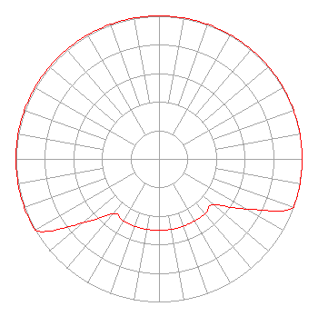 | ||||||||||||||||||
| Azimuth | Ratio | Azimuth | Ratio | Azimuth | Ratio | Azimuth | Ratio | ||||||||||||
| 0 | 1.000 | 10 | 1.000 | 20 | 1.000 | 30 | 1.000 | ||||||||||||
| 40 | 1.000 | 50 | 1.000 | 60 | 1.000 | 70 | 1.000 | ||||||||||||
| 80 | 1.000 | 90 | 1.000 | 100 | 1.000 | 110 | 1.000 | ||||||||||||
| 120 | 0.700 | 130 | 0.500 | 140 | 0.500 | 150 | 0.500 | ||||||||||||
| 160 | 0.500 | 170 | 0.500 | 180 | 0.500 | 190 | 0.500 | ||||||||||||
| 200 | 0.500 | 210 | 0.500 | 220 | 0.500 | 230 | 0.700 | ||||||||||||
| 240 | 1.000 | 250 | 1.000 | 260 | 1.000 | 270 | 1.000 | ||||||||||||
| 280 | 1.000 | 290 | 1.000 | 300 | 1.000 | 310 | 1.000 | ||||||||||||
| 320 | 1.000 | 330 | 1.000 | 340 | 1.000 | 350 | 1.000 | ||||||||||||
Structure Registration Number 1030883 Structure Type: TOWER Registered To: KOVAS, FRANK Structure Address: 5446 Cr 29 Auburn, IN County Name: DeKalb County ASR Issued: 11/06/1997 Date Built: 01/01/1966 Site Elevation: 265.2 m (870 ft.) Structure Height: 94.8 m (311 ft.) Height Overall: 94.8 m (311 ft.) Overall Height AMSL: 360 m (1181 ft.) FAA Determination: 09/30/1966 FAA Study #: CHI-OE-66-30 Paint & Light FAA Chapters: 1, 3, 12, 21 RED LIGHTS/PAINT 41-20-01.0 N 85-03-08.0 W (NAD 83) 41-20-00.8 N 85-03-08.1 W (Converted to NAD 27) |
1015 Valdosta Drive Fort Wayne, IN 46825 Phone: 260-387-6914 Not-for-Profit | Title: Board Member Date: 07/30/2021 Application Certifier RAYMOND S. AND DOROTHY N. MOORE FOUNDATION, INC. Raymond S. And Dorothy N. Moore Foundation, Inc. 1015 Valdosta Drive Fort Wayne, IN 46825 Applicant DONALD MARTIN Donald E. Martin, P.c. Falls Church, VA 22041 Attorney | |||||||||||||||||