
FCCInfo.com
A Service of Cavell, Mertz & Associates, Inc.
(855) FCC-INFO
|
|
|
|  |
|
|||||||||||||||
|
|
KUHF Channel: 204C 88.7 MHz Houston, Texas Service: FM - A full-service FM station or application. Facility ID: 69150 Fac. Service: FM Analog & Digital Status: License Application Accepted: 08/30/2021 Application Granted: 05/27/2022 File Number: -0000150925 License Expires: 08/01/2029 Application Type: Amendment FCC Website Links: LMS Facility Details This Application Other KUHF Applications Other KUHF Applications in CDBS Including Superseded Applications Mailing Address Correspondence for KUHF Correspondence related to application -0000150925 Service Contour - Open Street Map or USGS Map (60 dBu) Service Contour - KML / Google Earth (60 dBu) Public Inspection Files History Cards for KUHF Facility Type: NON-COMMERCIAL EDUC. FM Class: C, A Zone II station; with exactly 100kW ERP and a class contour distance 72km-92km Site Location: 29-34-16.0 N 95-30-38.0 W (NAD 83) Site Location: 29-34-15.2 N 95-30-37.2 W (Converted to NAD 27) Effective Radiated Power: 100 kW Horiz. ; 60 kW Vert. Antenna Center HAAT: 596 m (1955 ft.) Antenna Center AMSL: 615 m (2018 ft.) Antenna Center HAG: 592 m (1942 ft.) Calculated Site Elevation: 23 m. (75 ft.) Height Overall*: 601.4 m (1973 ft.) (* As Filed In This Application, may differ from ASR Data, Below.) Directional Antenna Antenna Make/Model: AlanDick Broadcast LTD LAMBDA-8 Antenna ID: 134052 Polarization: | ||||||||||||||||||
| Antenna Data for Antenna Id: 134052 KUHF FM File: -0000150925 AlanDick Broadcast LTD - LAMBDA-8 Service: FM | 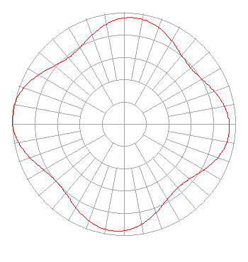 | ||||||||||||||||||
| Azimuth | Ratio | Azimuth | Ratio | Azimuth | Ratio | Azimuth | Ratio | ||||||||||||
| 0 | 0.950 | 10 | 0.952 | 20 | 0.917 | 30 | 0.858 | ||||||||||||
| 40 | 0.802 | 50 | 0.780 | 60 | 0.804 | 70 | 0.858 | ||||||||||||
| 80 | 0.913 | 90 | 0.944 | 100 | 0.937 | 110 | 0.892 | ||||||||||||
| 120 | 0.827 | 130 | 0.768 | 140 | 0.749 | 150 | 0.780 | ||||||||||||
| 160 | 0.846 | 170 | 0.914 | 180 | 0.957 | 190 | 0.960 | ||||||||||||
| 200 | 0.925 | 210 | 0.866 | 220 | 0.813 | 230 | 0.796 | ||||||||||||
| 240 | 0.829 | 250 | 0.894 | 260 | 0.960 | 270 | 1.000 | ||||||||||||
| 280 | 0.998 | 290 | 0.954 | 300 | 0.882 | 310 | 0.811 | ||||||||||||
| 320 | 0.774 | 330 | 0.790 | 340 | 0.846 | 350 | 0.909 | ||||||||||||
Structure Registration Number 1064696 Structure Type: GTOWER Registered To: American Towers LLC Structure Address: 4124 2/3 Texas Parkway (#282638) Missouri City, TX County Name: Fort Bend County ASR Issued: 02/21/2022 Date Built: 11/19/2001 Site Elevation: 23.4 m (77 ft.) Structure Height: 561.5 m (1842 ft.) Height Overall: 601.4 m (1973 ft.) Overall Height AMSL: 624.8 m (2050 ft.) FAA Determination: 01/06/2022 FAA Study #: 2022-ASW-155-OE FAA Circular #: 70/7460-1M Paint & Light FAA Chapters: 4, 9, 15 PRIOR STUDY 1998-ASW-4226-OE 29-34-15.7 N 95-30-38.3 W (NAD 83) 29-34-14.9 N 95-30-37.5 W (Converted to NAD 27) |
4302 University Drive - 311 E. Cullen Building Houston, TX 77204-2028 Phone: 713-743-0887 Government Entity | Title: Senior Vice Chancellor Date: 08/30/2021 Application Certifier UNIVERSITY OF HOUSTON SYSTEM University Of Houston System 311 E. Cullen Building 4800 Calhoun Houston, TX 77204 Applicant Ryan Wilhour Kessler And Gehman 507 Nw 60th St Ste D Gainesville, FL 32607 Consulting Engineer Derek Teslik Gray Miller Persh Llp 2233 Wisconsin Avenue, Nw Suite 226 Washington, DC 20007 Joshua Adams Houston Public Media 4343 Elgin Street Houston, TX 77204 | |||||||||||||||||
| |||||||||||||||||||