
FCCInfo.com
A Service of Cavell, Mertz & Associates, Inc.
(855) FCC-INFO
|
|
|
|
|
||||||||||||||||
|
|
Channel: 218C3 91.5 MHz Waukesha, Wisconsin Service: FM - A full-service FM station or application. Facility ID: 762473 Fac. Service: FM Status: Construction Permit Application Accepted: 11/08/2021 Application Pending: 11/08/2021 File Number: -0000166752 CP Expires: 00/00/0000 Application Type: Non-Commercial Educational New NCE FM CP FCC Website Links: LMS Facility Details This Application Other Applications Other Applications in CDBS Including Superseded Applications Mailing Address Correspondence for Correspondence related to application -0000166752 Service Contour - Open Street Map or USGS Map (60 dBu) Service Contour - KML / Google Earth (60 dBu) Facility Type: NON-COMMERCIAL EDUC. FM Class: C3, A Zone II station; with 6kW-25kW ERP and a class contour distance 28km-39km Site Location: 43-09-39.3 N 88-22-12.7 W (NAD 83) Site Location: 43-09-39.3 N 88-22-12.4 W (Converted to NAD 27) Effective Radiated Power: 25 kW Antenna Center HAAT: 50 m (164 ft.) Antenna Center AMSL: 340.7 m (1118 ft.) Antenna Center HAG: 60 m (197 ft.) Site Elevation: 280.7 m. (921 ft.) Height Overall*: 77.7 m (255 ft.) (* As Filed In This Application, may differ from ASR Data, Below.) Directional Antenna Antenna Make/Model: None Antenna ID: 69-2019-08-06 Polarization: | ||||||||||||||||||
| Antenna Data for Antenna Id: 69-2019-08-06 FM File: -0000166752 None - Service: FM | 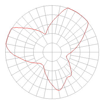 | ||||||||||||||||||
| Azimuth | Ratio | Azimuth | Ratio | Azimuth | Ratio | Azimuth | Ratio | ||||||||||||
| 0 | 0.640 | 10 | 0.800 | 20 | 1.000 | 30 | 1.000 | ||||||||||||
| 40 | 1.000 | 50 | 1.000 | 60 | 0.810 | 70 | 0.650 | ||||||||||||
| 80 | 0.520 | 90 | 0.420 | 100 | 0.340 | 110 | 0.330 | ||||||||||||
| 120 | 0.410 | 130 | 0.510 | 140 | 0.640 | 150 | 0.640 | ||||||||||||
| 160 | 0.740 | 170 | 0.830 | 180 | 0.700 | 190 | 0.560 | ||||||||||||
| 200 | 0.450 | 210 | 0.360 | 220 | 0.340 | 230 | 0.370 | ||||||||||||
| 240 | 0.460 | 250 | 0.570 | 260 | 0.710 | 270 | 0.890 | ||||||||||||
| 280 | 1.000 | 290 | 1.000 | 300 | 1.000 | 310 | 0.800 | ||||||||||||
| 320 | 0.640 | 330 | 0.510 | 340 | 0.410 | 350 | 0.510 | ||||||||||||
Structure Registration Number 1216977 Structure Type: LTOWER Registered To: SBA Structures, LLC Structure Address: N78 W31400 Kilbourne Road (wi21167-a) North Lake, WI County Name: Waukesha County ASR Issued: 05/15/2023 Date Built: 07/10/2001 Site Elevation: 280.7 m (921 ft.) Structure Height: 76.2 m (250 ft.) Height Overall: 77.7 m (255 ft.) Overall Height AMSL: 358.4 m (1176 ft.) FAA Determination: 12/01/2022 FAA Study #: 2022-AGL-1112-OE FAA Circular #: 70/7460-1L Paint & Light FAA Chapters: 4, 8, 12 PRIOR STUDY 2017-AGL-15308-OE 43-09-39.3 N 88-22-12.7 W (NAD 83) 43-09-39.3 N 88-22-12.4 W (Converted to NAD 27) |
Title: President Date: 11/08/2021 Application Certifier Community Public Radio, Inc. Po Box 6767 Athens, GA 30604 Applicant Charles Burkhart Sterling Communications, Inc. Po Box 1877 Lafayette, GA 30728 Chief Engineer James E Price, III Sterling Communications, Inc. Po Box 1877 Lafayette, GA 30728 Legal Representative | ||||||||||||||||||