
FCCInfo.com
A Service of Cavell, Mertz & Associates, Inc.
(855) FCC-INFO
|
|
W278CJ from 10/07/2003 |
|
|
||||||||||||||||
|
|
W278CJ Channel: 278D 103.5 MHz Manchester, New Hampshire Service: FX - A translator or application for a translator. Facility ID: 138757 Fac. Service: FX Programming Delivery Method: Unspecified Status: License Application Accepted: 09/09/2021 Application Granted: 09/10/2021 File Number: -0000122268 License Expires: 04/01/2022 Application Type: Amendment FCC Website Links: LMS Facility Details This Application Other W278CJ Applications Other W278CJ Applications in CDBS Including Superseded Applications Mailing Address Correspondence for W278CJ Correspondence related to application -0000122268 Service Contour - Open Street Map or USGS Map (60 dBu) Service Contour - KML / Google Earth (60 dBu) Facility Type: FM STATION Class: D, A Noncommercial educational operating with no more than 10W Site Location: 43-00-38.0 N 71-30-13.0 W (NAD 83) Site Location: 43-00-37.7 N 71-30-14.8 W (Converted to NAD 27) Effective Radiated Power: 0 kW Horiz. ; 0.25 kW Vert. Transmitter Output Power: 0.103 kW Antenna Center HAAT: 0 m Antenna Center AMSL: 0 m Horiz.; 143.3 m Vert. Antenna Center HAG: 0 m Horiz.; 58 m Vert. Site Elevation: 85.3 m. (280 ft.) Height Overall*: 62.5 m (205 ft.) (* As Filed In This Application, may differ from ASR Data, Below.) Directional Antenna Antenna Make/Model: Nicom BLD-4/P Antenna ID: 129752 Polarization: H
| ||||||||||||||||||
| Antenna Data for Antenna Id: 129752 W278CJ FX File: -0000122268 Nicom - BLD-4/P Service: FX | 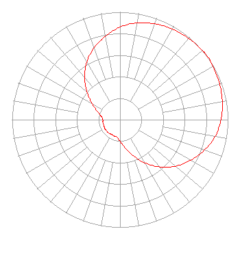 | ||||||||||||||||||
| Azimuth | Ratio | Azimuth | Ratio | Azimuth | Ratio | Azimuth | Ratio | ||||||||||||
| 0 | 0.859 | 10 | 0.913 | 20 | 0.947 | 30 | 0.971 | ||||||||||||
| 40 | 0.986 | 50 | 0.997 | 53 | 1.000 | 60 | 0.993 | ||||||||||||
| 70 | 0.981 | 80 | 0.962 | 90 | 0.935 | 100 | 0.895 | ||||||||||||
| 110 | 0.830 | 120 | 0.755 | 130 | 0.672 | 140 | 0.573 | ||||||||||||
| 150 | 0.463 | 160 | 0.355 | 170 | 0.265 | 180 | 0.200 | ||||||||||||
| 190 | 0.165 | 200 | 0.161 | 210 | 0.158 | 220 | 0.162 | ||||||||||||
| 230 | 0.162 | 240 | 0.163 | 250 | 0.159 | 260 | 0.161 | ||||||||||||
| 270 | 0.159 | 280 | 0.175 | 290 | 0.222 | 300 | 0.298 | ||||||||||||
| 310 | 0.398 | 320 | 0.509 | 330 | 0.615 | 340 | 0.706 | ||||||||||||
| 350 | 0.785 | ||||||||||||||||||
Structure Registration Number 1035053 Structure Type: 5TA1 Registered To: Absolute Broadcasting LLC Structure Address: Twr 1 376 Goffstown Back Rd Goffstown, NH County Name: Hillsborough County ASR Issued: 09/01/2020 Date Built: 01/01/1959 Site Elevation: 85.3 m (280 ft.) Structure Height: 62.5 m (205 ft.) Height Overall: 62.5 m (205 ft.) Overall Height AMSL: 147.8 m (485 ft.) Paint & Light FAA Chapters: 1, 3, 11, 21 43-00-38.0 N 71-30-13.0 W (NAD 83) 43-00-37.7 N 71-30-14.8 W (Converted to NAD 27) |
20 Trafalgar Square Suite 610 Nashua, NH 03063 Phone: 603-880-0502 Limited Liability Company | Title: Managing Member Date: 09/09/2021 Application Certifier ABSOLUTE BROADCASTING, LLC Absolute Broadcasting, Llc 20 Trafalgar Square Suite 610 Nashua, NH 03063 Applicant Aaron P. Shainis, Esq Shainis & Peltzman, Chartered 1850 M St Nw Suite 240 Washington, DC 20036 Legal Counsel Thomas R. Ray III Thomas R. Ray Consulting 377 Chestnut Ave New Windsor, NY 12553 Contract Engineer Dennis Jackson Technical Consultant 19 Boas Lane Wilton, CT 06897 Technical Consultant | |||||||||||||||||