
FCCInfo.com
A Service of Cavell, Mertz & Associates, Inc.
(855) FCC-INFO
|
|
|
|
|
||||||||||||||||
|
|
K296FT Channel: 296D 107.1 MHz West Haven, Oregon Service: FX - A translator or application for a translator. Facility ID: 158590 Fac. Service: FX Programming Delivery Method: Unspecified Status: License Application Accepted: 09/16/2021 Application Granted: 10/13/2021 File Number: -0000159512 License Expires: 02/01/2022 Application Type: License To Cover FCC Website Links: LMS Facility Details This Application Other K296FT Applications Other K296FT Applications in CDBS Including Superseded Applications Mailing Address Correspondence for K296FT Correspondence related to application -0000159512 Service Contour - Open Street Map or USGS Map (60 dBu) Service Contour - KML / Google Earth (60 dBu) Facility Type: NON-COMMERCIAL EDUC. FM Class: D, A Noncommercial educational operating with no more than 10W Site Location: 45-29-19.4 N 122-41-44.4 W (NAD 83) Site Location: 45-29-20.0 N 122-41-40.1 W (Converted to NAD 27) Effective Radiated Power: 0.034 kW Transmitter Output Power: 0.21 kW Antenna Center HAAT: 0 m Antenna Center AMSL: 352.3 m (1156 ft.) Antenna Center HAG: 42 m (138 ft.) Site Elevation: 310.3 m. (1018 ft.) Height Overall*: 189 m (620 ft.) (* As Filed In This Application, may differ from ASR Data, Below.) Directional Antenna Antenna Make/Model: Bext TFC2K-D Antenna ID: 134496 Polarization: H
| ||||||||||||||||||
| Antenna Data for Antenna Id: 134496 K296FT FX File: -0000159512 Bext - TFC2K-D Service: FX | 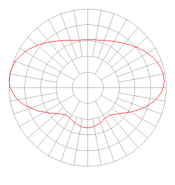 | ||||||||||||||||||
| Azimuth | Ratio | Azimuth | Ratio | Azimuth | Ratio | Azimuth | Ratio | ||||||||||||
| 0 | 0.605 | 10 | 0.613 | 20 | 0.637 | 30 | 0.675 | ||||||||||||
| 40 | 0.730 | 50 | 0.800 | 60 | 0.876 | 70 | 0.941 | ||||||||||||
| 80 | 0.975 | 90 | 0.961 | 100 | 0.880 | 110 | 0.754 | ||||||||||||
| 120 | 0.624 | 130 | 0.520 | 140 | 0.459 | 150 | 0.449 | ||||||||||||
| 160 | 0.473 | 170 | 0.499 | 180 | 0.512 | 190 | 0.500 | ||||||||||||
| 200 | 0.473 | 210 | 0.445 | 220 | 0.451 | 230 | 0.516 | ||||||||||||
| 240 | 0.628 | 250 | 0.765 | 260 | 0.897 | 270 | 0.981 | ||||||||||||
| 280 | 1.000 | 290 | 0.972 | 300 | 0.910 | 310 | 0.831 | ||||||||||||
| 320 | 0.752 | 330 | 0.686 | 340 | 0.639 | 350 | 0.612 | ||||||||||||
Structure Registration Number 1033770 Structure Type: TOWER Registered To: Stonehenge Towers, LLC Structure Address: 4700 Council Crest Dr Portland, OR County Name: Multnomah County ASR Issued: 07/09/2008 Date Built: 06/05/1991 Site Elevation: 310.3 m (1018 ft.) Structure Height: 153.9 m (505 ft.) Height Overall: 189 m (620 ft.) Overall Height AMSL: 499.3 m (1638 ft.) FAA Determination: 08/13/2002 FAA Study #: 2002-ANM-1415-OE FAA Circular #: 70/7460-1K Paint & Light FAA Chapters: 3, 4, 5, 12 Removed expiration date from determination. Scenario 1./jjs/case#635066 45-29-19.4 N 122-41-44.4 W (NAD 83) 45-29-20.0 N 122-41-40.1 W (Converted to NAD 27) |
829 Ne 8th St Gresham, OR 97030 Phone: 503-667-8848 Not-for-Profit | Title: Deputy Director And Head Of Production Date: 09/16/2021 Application Certifier METROEAST COMMUNITY MEDIA Metroeast Community Media 829 Ne 8th St Gresham, OR 97030 Applicant Michael D Brown Brown Broadcast Services, Inc. 3740 Sw Comus St Portland, OR 97219 Engineering Consultant | |||||||||||||||||