
FCCInfo.com
A Service of Cavell, Mertz & Associates, Inc.
(855) FCC-INFO
|
|
|
|  |
|
|||||||||||||||
|
|
WZWG Channel: 219A 91.7 MHz West Grove, Pennsylvania Service: FM - A full-service FM station or application. Facility ID: 173248 Fac. Service: FM Status: Construction Permit Application Accepted: 09/14/2021 Application Granted: 01/28/2022 File Number: -0000159336 WZWG CP Expires: 01/28/2025 Application Type: Minor Modification FCC Website Links: LMS Facility Details This Application Other WZWG Applications Other WZWG Applications in CDBS Including Superseded Applications Mailing Address Correspondence for WZWG Correspondence related to application -0000159336 Service Contour - Open Street Map or USGS Map (60 dBu) Service Contour - KML / Google Earth (60 dBu) Public Inspection Files Facility Type: NON-COMMERCIAL EDUC. FM Class: A, A Zone I; I-A; or II station; with 0.1kW-6kW ERP and a class contour distance <=28km Site Location: 39-49-19.7 N 75-54-42.2 W (NAD 83) Site Location: 39-49-19.3 N 75-54-43.4 W (Converted to NAD 27) Effective Radiated Power: 0 kW Horiz. ; 0.4 kW Vert. Antenna Center HAAT: 0 m Horiz.; 144 m Vert. Antenna Center AMSL: 0 m Horiz.; 279 m Vert. Antenna Center HAG: 0 m Horiz.; 120 m Vert. Site Elevation: 158.8 m. (521 ft.) Height Overall*: 145.7 m (478 ft.) (* As Filed In This Application, may differ from ASR Data, Below.) Directional Antenna Antenna Make/Model: None Antenna ID: 1006063 Polarization:
| ||||||||||||||||||
| Antenna Data for Antenna Id: 1006063 WZWG FM File: -0000159336 None - Service: FM | 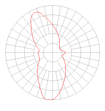 | ||||||||||||||||||
| Azimuth | Ratio | Azimuth | Ratio | Azimuth | Ratio | Azimuth | Ratio | ||||||||||||
| 0 | 0.588 | 10 | 0.467 | 20 | 0.371 | 30 | 0.295 | ||||||||||||
| 40 | 0.234 | 50 | 0.186 | 60 | 0.178 | 70 | 0.178 | ||||||||||||
| 80 | 0.218 | 90 | 0.274 | 100 | 0.237 | 110 | 0.217 | ||||||||||||
| 120 | 0.272 | 130 | 0.343 | 140 | 0.431 | 150 | 0.543 | ||||||||||||
| 160 | 0.683 | 170 | 0.860 | 180 | 1.000 | 190 | 0.983 | ||||||||||||
| 200 | 0.781 | 210 | 0.620 | 220 | 0.502 | 230 | 0.399 | ||||||||||||
| 240 | 0.317 | 250 | 0.300 | 260 | 0.300 | 270 | 0.300 | ||||||||||||
| 280 | 0.280 | 290 | 0.353 | 300 | 0.444 | 310 | 0.558 | ||||||||||||
| 320 | 0.703 | 330 | 0.885 | 340 | 0.911 | 350 | 0.740 | ||||||||||||
Structure Registration Number 1025380 Structure Type: LTOWER Registered To: American Towers LLC Structure Address: Us Rt 1 And 896 Ne Corner Lot 4 Industrial Park (010319 / Forestville) Lincoln University, PA County Name: Chester County ASR Issued: 11/22/2022 Date Built: 09/09/2008 Site Elevation: 158.8 m (521 ft.) Structure Height: 138.4 m (454 ft.) Height Overall: 145.7 m (478 ft.) Overall Height AMSL: 304.5 m (999 ft.) FAA Determination: 11/17/2022 FAA Study #: 2021-AEA-15683-OE FAA Circular #: 70/7460-1H Paint & Light FAA Chapters: 4, 8, 13 PRIOR STUDY 2008-AEA-3771-OE 39-49-19.7 N 75-54-42.2 W (NAD 83) 39-49-19.3 N 75-54-43.4 W (Converted to NAD 27) |
55 East Main Street Marlton, NJ 08053 Phone: 856-983-1662 Not-for-Profit | Title: President Date: 09/14/2021 Application Certifier HOPE CHRISTIAN CHURCH OF MARLTON, INC. Hope Christian Church Of Marlton, Inc. 55 East Main Street Marlton, NJ 08053 Applicant Matthew H. McCormick, Esq Fletcher, Heald & Hildreth, P.l.c. 1300 North 17th Street 11th Floor Arlington, VA 22209 ROBERT Moore Rcm Engineering 1908 Sweetbriar Drive Goshen, IN 46528 CONSULTING ENGINEER | |||||||||||||||||