
FCCInfo.com
A Service of Cavell, Mertz & Associates, Inc.
(855) FCC-INFO
|
|
|
|
|
||||||||||||||||
|
|
W275DA Channel: 275D 102.9 MHz Providence, Rhode Island Service: FX - A translator or application for a translator. Facility ID: 202495 Fac. Service: FX Programming Delivery Method: Unspecified Status: License Application Accepted: 09/22/2021 Application Granted: 10/15/2021 File Number: -0000159933 License Expires: 04/01/2022 Application Type: License To Cover FCC Website Links: LMS Facility Details This Application Other W275DA Applications Other W275DA Applications in CDBS Including Superseded Applications Mailing Address Correspondence for W275DA Correspondence related to application -0000159933 Service Contour - Open Street Map or USGS Map (60 dBu) Service Contour - KML / Google Earth (60 dBu) Facility Type: FM STATION Class: D, A Noncommercial educational operating with no more than 10W Site Location: 41-48-17.0 N 71-28-22.0 W (NAD 83) Site Location: 41-48-16.6 N 71-28-23.8 W (Converted to NAD 27) Effective Radiated Power: 0.05 kW Antenna Center HAAT: 0 m Antenna Center AMSL: 222 m (728 ft.) Antenna Center HAG: 133 m (436 ft.) Site Elevation: 89 m. (292 ft.) Height Overall*: 163.1 m (535 ft.) (* As Filed In This Application, may differ from ASR Data, Below.) Directional Antenna Antenna Make/Model: Scala CL-FM/SRM Antenna ID: 133949 Polarization: H
| ||||||||||||||||||
| Antenna Data for Antenna Id: 133949 W275DA FX File: -0000159933 Scala - CL-FM/SRM Service: FX | 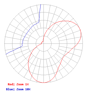 | ||||||||||||||||||
| Azimuth | Ratio | Azimuth | Ratio | Azimuth | Ratio | Azimuth | Ratio | ||||||||||||
| 0 | 0.137 | 10 | 0.268 | 20 | 0.424 | 30 | 0.602 | ||||||||||||
| 40 | 0.748 | 50 | 0.878 | 60 | 0.969 | 70 | 1.000 | ||||||||||||
| 80 | 0.966 | 90 | 0.871 | 100 | 0.746 | 110 | 0.672 | ||||||||||||
| 120 | 0.623 | 130 | 0.623 | 140 | 0.672 | 150 | 0.746 | ||||||||||||
| 160 | 0.871 | 170 | 0.966 | 180 | 1.000 | 190 | 0.969 | ||||||||||||
| 200 | 0.878 | 210 | 0.748 | 220 | 0.602 | 230 | 0.424 | ||||||||||||
| 240 | 0.268 | 250 | 0.137 | 260 | 0.064 | 270 | 0.054 | ||||||||||||
| 280 | 0.053 | 290 | 0.051 | 300 | 0.050 | 310 | 0.050 | ||||||||||||
| 320 | 0.051 | 330 | 0.053 | 340 | 0.054 | 350 | 0.064 | ||||||||||||
Structure Registration Number 1021870 Structure Type: GTOWER Registered To: VB Nimbus, LLC Structure Address: Ipswitch St On Neutaconkanut Hill Johnston, RI County Name: Providence County ASR Issued: 10/14/2020 Date Built: 01/01/1948 Site Elevation: 89 m (292 ft.) Structure Height: 147.2 m (483 ft.) Height Overall: 163.1 m (535 ft.) Overall Height AMSL: 252.1 m (827 ft.) FAA Determination: 02/24/2015 FAA Study #: 2014-ANE-2394-OE Paint & Light FAA Chapters: 1, 3, 4, 13, 21 Continue As Is OM&L = PAINT/RED LIGHTS 41-48-17.0 N 71-28-22.0 W (NAD 83) 41-48-16.6 N 71-28-23.8 W (Converted to NAD 27) |
One Union Station Providence, RI 02903 Phone: 401-351-2800 Not-for-Profit | Title: President, Ceo And General Manager Date: 09/22/2021 Application Certifier RHODE ISLAND PUBLIC RADIO Rhode Island Public Radio One Union Station Providence, RI 02903 Applicant DAVID J DOHERTY Skywaves Consulting, Llc Portland, OR 97212 JOHN WELLS KING, ESQ Law Office Of John Wells King, Pllc 4051 Shoal Creek Lane East Jacksonville, FL 32225 Aaron Read Rhode Island Public Radio, Inc 1 Union Station Providence, RI 02903 Chief Engineer | |||||||||||||||||