
FCCInfo.com
A Service of Cavell, Mertz & Associates, Inc.
(855) FCC-INFO
|
|
|
|
|
||||||||||||||||
|
|
W275AJ Channel: 275D 102.9 MHz Muncie, Indiana Service: FX - A translator or application for a translator. Facility ID: 156385 Fac. Service: FX Programming Delivery Method: Unspecified Status: License Application Accepted: 10/18/2021 Application Granted: 11/05/2021 File Number: -0000164027 License Expires: 08/01/2028 Application Type: License To Cover FCC Website Links: LMS Facility Details This Application Other W275AJ Applications Other W275AJ Applications in CDBS Including Superseded Applications Mailing Address Correspondence for W275AJ Correspondence related to application -0000164027 Service Contour - Open Street Map or USGS Map (60 dBu) Service Contour - KML / Google Earth (60 dBu) Facility Type: FM STATION Class: D, A Noncommercial educational operating with no more than 10W Site Location: 40-05-37.2 N 85-23-31.9 W (NAD 83) Site Location: 40-05-37.0 N 85-23-32.0 W (Converted to NAD 27) Effective Radiated Power: 0.25 kW Antenna Center HAAT: 0 m Antenna Center AMSL: 535 m (1755 ft.) Antenna Center HAG: 232 m (761 ft.) Site Elevation: 303 m. (994 ft.) Height Overall*: 259 m (850 ft.) (* As Filed In This Application, may differ from ASR Data, Below.) Directional Antenna Antenna Make/Model: Propagation System Inc PSIFML-1-DA Antenna ID: 134149 Polarization: H
| ||||||||||||||||||
| Antenna Data for Antenna Id: 134149 W275AJ FX File: -0000164027 Propagation System Inc - PSIFML-1-DA Service: FX | 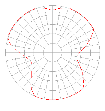 | ||||||||||||||||||
| Azimuth | Ratio | Azimuth | Ratio | Azimuth | Ratio | Azimuth | Ratio | ||||||||||||
| 0 | 0.900 | 10 | 0.950 | 20 | 1.000 | 30 | 1.000 | ||||||||||||
| 40 | 1.000 | 50 | 1.000 | 60 | 1.000 | 70 | 0.850 | ||||||||||||
| 80 | 0.700 | 90 | 0.570 | 100 | 0.525 | 110 | 0.570 | ||||||||||||
| 120 | 0.700 | 130 | 0.850 | 140 | 1.000 | 150 | 1.000 | ||||||||||||
| 160 | 1.000 | 170 | 1.000 | 180 | 1.000 | 190 | 1.000 | ||||||||||||
| 200 | 1.000 | 210 | 0.890 | 220 | 0.700 | 230 | 0.570 | ||||||||||||
| 240 | 0.505 | 250 | 0.505 | 260 | 0.570 | 270 | 0.700 | ||||||||||||
| 280 | 0.890 | 290 | 1.000 | 300 | 1.000 | 310 | 1.000 | ||||||||||||
| 320 | 1.000 | 330 | 1.000 | 340 | 1.000 | 350 | 0.950 | ||||||||||||
Structure Registration Number 1243031 Structure Type: Registered To: Ball State University Structure Address: The Tower Is Located At The Intersection Of Cr 50 W And Cr 700 S. Muncie, IN County Name: Delaware County ASR Issued: 05/12/2021 Date Built: 09/06/2005 Site Elevation: 303 m (994 ft.) Structure Height: 244 m (801 ft.) Height Overall: 259 m (850 ft.) Overall Height AMSL: 562 m (1844 ft.) FAA Determination: 10/09/2003 FAA Study #: 2003-AGL-1451-OE FAA Circular #: 70/7460-1K Paint & Light FAA Chapters: 4, 9, 12 Removed expiration and final dates from determination. Scenario 2./jjs/case#635066 40-05-37.0 N 85-23-32.0 W (NAD 83) 40-05-36.8 N 85-23-32.1 W (Converted to NAD 27) |
800 East 29th Street Muncie, IN 47302 Phone: 765-288-4403 Limited Liability Company | Title: President Date: 10/18/2021 Application Certifier WOOF BOOM RADIO MUNCIE LICENSE LLC Woof Boom Radio Muncie License Llc 800 East 29th Street Muncie, IN 47302 Applicant John C Trent, Esq. Putbrese, Hunsaker And Trent, Pc 200 South Church Street Woodstock, VA 22664 FCC Legal Counsel Jeremy D Ruck, PE Jeremy Ruck & Associates, Inc. Canton, IL 61520 Consulting Engineer | |||||||||||||||||