
FCCInfo.com
A Service of Cavell, Mertz & Associates, Inc.
(855) FCC-INFO
|
|
|
|
|
||||||||||||||||
|
|
W270DS Channel: 270D 101.9 MHz Concord, New Hampshire Service: FX - A translator or application for a translator. Facility ID: 202530 Fac. Service: FX Programming Delivery Method: Unspecified Status: License Application Accepted: 10/25/2021 Application Granted: 11/09/2021 File Number: -0000164627 License Expires: 04/01/2022 Application Type: License To Cover FCC Website Links: LMS Facility Details This Application Other W270DS Applications Other W270DS Applications in CDBS Including Superseded Applications Mailing Address Correspondence for W270DS Correspondence related to application -0000164627 Service Contour - Open Street Map or USGS Map (60 dBu) Service Contour - KML / Google Earth (60 dBu) Facility Type: FM STATION Class: D, A Noncommercial educational operating with no more than 10W Site Location: 42-58-54.7 N 71-35-19.6 W (NAD 83) Site Location: 42-58-54.4 N 71-35-21.3 W (Converted to NAD 27) Effective Radiated Power: 0.065 kW Antenna Center HAAT: 0 m Antenna Center AMSL: 420 m (1378 ft.) Antenna Center HAG: 30 m (98 ft.) Site Elevation: 390 m. (1280 ft.) Height Overall*: 74 m (243 ft.) (* As Filed In This Application, may differ from ASR Data, Below.) Directional Antenna Antenna Make/Model: Propagation System Inc PSIFMT-1A-6DB Antenna ID: 133784 Polarization: H
| ||||||||||||||||||
| Antenna Data for Antenna Id: 133784 W270DS FX File: -0000164627 Propagation System Inc - PSIFMT-1A-6DB Service: FX | 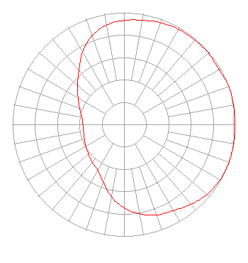 | ||||||||||||||||||
| Azimuth | Ratio | Azimuth | Ratio | Azimuth | Ratio | Azimuth | Ratio | ||||||||||||
| 0 | 0.929 | 10 | 0.945 | 20 | 0.966 | 30 | 0.981 | ||||||||||||
| 40 | 0.986 | 50 | 0.988 | 60 | 0.982 | 70 | 0.999 | ||||||||||||
| 80 | 0.995 | 90 | 0.990 | 100 | 0.996 | 110 | 1.000 | ||||||||||||
| 120 | 0.994 | 130 | 0.971 | 140 | 0.932 | 150 | 0.889 | ||||||||||||
| 160 | 0.860 | 170 | 0.811 | 180 | 0.744 | 190 | 0.656 | ||||||||||||
| 200 | 0.547 | 210 | 0.472 | 220 | 0.443 | 230 | 0.415 | ||||||||||||
| 240 | 0.395 | 250 | 0.378 | 260 | 0.368 | 270 | 0.369 | ||||||||||||
| 280 | 0.384 | 290 | 0.423 | 300 | 0.475 | 310 | 0.545 | ||||||||||||
| 320 | 0.628 | 330 | 0.745 | 340 | 0.840 | 350 | 0.902 | ||||||||||||
Structure Registration Number 1048913 Structure Type: TOWER Registered To: Crown Atlantic Company LLC Structure Address: Perimeter Road Goffstown, NH County Name: Hillsborough County ASR Issued: 05/06/2016 Date Built: 12/16/1994 Site Elevation: 389.8 m (1279 ft.) Structure Height: 61.3 m (201 ft.) Height Overall: 74.4 m (244 ft.) Overall Height AMSL: 464.2 m (1523 ft.) FAA Determination: 06/03/2010 FAA Study #: 2010-ANE-417-OE FAA Circular #: 70/7460-1K Paint & Light FAA Chapters: 3, 4, 5, 12 OM&L to remain the same as prior study = PAINT/RED LIGHTS 42-58-54.7 N 71-35-19.5 W (NAD 83) 42-58-54.4 N 71-35-21.2 W (Converted to NAD 27) |
37 Redington Rd. Concord, NH 03301 Phone: 603-540-7309 Limited Liability Company | Title: Member Date: 10/25/2021 Application Certifier NEW HAMPSHIRE FAMILY RADIO LLC New Hampshire Family Radio Llc 37 Redington Rd. Concord, NH 03301 Applicant Daniel R. Guy, Jr. Daniel R. Guy Jr. 2 Brinton Drive Nashua, NH 03064 Technical Consultant MATTHEW H. MCCORMICK Fletcher, Heald & Hildreth, Plc 1300 North 17th Street 11th Floor Arlington, VA 22209 CLIFTON G. Moor Bromo Communications, Inc. Bromo Communications, Inc. 3600 Dallas Hwy - Suite 230 - Pmb 164 Marietta, GA 30064 TECHNICAL CONSULTANT | |||||||||||||||||