
FCCInfo.com
A Service of Cavell, Mertz & Associates, Inc.
(855) FCC-INFO
|
|
|
|
|
||||||||||||||||
|
|
Channel: 207C1 89.3 MHz Carrabelle, Florida Service: FM - A full-service FM station or application. Facility ID: 768253 Fac. Service: FM Status: Construction Permit Application Accepted: 11/08/2021 Application Pending: 08/03/2022 File Number: -0000166680 CP Expires: 00/00/0000 Application Type: Non-Commercial Educational Amendment FCC Website Links: LMS Facility Details This Application Other Applications Other Applications in CDBS Including Superseded Applications Mailing Address Correspondence for Correspondence related to application -0000166680 Service Contour - Open Street Map or USGS Map (60 dBu) Service Contour - KML / Google Earth (60 dBu) Facility Type: NON-COMMERCIAL EDUC. FM Class: C1, A Zone II station; with 50kW-100kW ERP and a class contour distance 52km-72km Site Location: 29-45-06.2 N 84-52-19.1 W (NAD 83) Site Location: 29-45-05.4 N 84-52-19.4 W (Converted to NAD 27) Effective Radiated Power: 100 kW Antenna Center HAAT: 168 m (551 ft.) Antenna Center AMSL: 175.3 m (575 ft.) Antenna Center HAG: 168 m (551 ft.) Site Elevation: 7.3 m. (24 ft.) Height Overall*: 182.8 m (600 ft.) (* As Filed In This Application, may differ from ASR Data, Below.) Directional Antenna Antenna Make/Model: None Antenna ID: 69-2019-08-06 Polarization: | ||||||||||||||||||
| Antenna Data for Antenna Id: 69-2019-08-06 FM File: -0000166680 None - Service: FM | 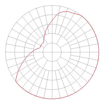 | ||||||||||||||||||
| Azimuth | Ratio | Azimuth | Ratio | Azimuth | Ratio | Azimuth | Ratio | ||||||||||||
| 0 | 0.671 | 10 | 0.839 | 20 | 0.920 | 30 | 0.950 | ||||||||||||
| 40 | 1.000 | 50 | 1.000 | 60 | 1.000 | 70 | 1.000 | ||||||||||||
| 80 | 1.000 | 90 | 1.000 | 100 | 1.000 | 110 | 1.000 | ||||||||||||
| 120 | 1.000 | 130 | 1.000 | 140 | 1.000 | 150 | 1.000 | ||||||||||||
| 160 | 1.000 | 170 | 1.000 | 180 | 1.000 | 190 | 1.000 | ||||||||||||
| 200 | 1.000 | 210 | 1.000 | 220 | 1.000 | 230 | 1.000 | ||||||||||||
| 240 | 0.839 | 250 | 0.671 | 260 | 0.537 | 270 | 0.430 | ||||||||||||
| 280 | 0.344 | 290 | 0.275 | 300 | 0.275 | 310 | 0.275 | ||||||||||||
| 320 | 0.275 | 330 | 0.344 | 340 | 0.430 | 350 | 0.537 | ||||||||||||
Structure Registration Number 1234843 Structure Type: GTOWER Registered To: SBA GC Towers, LLC Structure Address: 141 Otterslide Road (fl 15880-a) Eastpoint, FL County Name: Franklin County ASR Issued: 09/03/2014 Date Built: 09/20/2002 Site Elevation: 7.3 m (24 ft.) Structure Height: 177 m (581 ft.) Height Overall: 182.8 m (600 ft.) Overall Height AMSL: 190.1 m (624 ft.) FAA Determination: 08/05/2014 FAA Study #: 2014-ASO-5161-OE FAA Circular #: 70/7460-1K Paint & Light FAA Chapters: 3, 4, 5, 12 PRIOR STUDY 2002-ASO-1131-OE 29-45-06.2 N 84-52-19.1 W (NAD 83) 29-45-05.4 N 84-52-19.4 W (Converted to NAD 27) |
Title: President Date: 11/08/2021 Application Certifier Ethree Group, Inc. 271 Nw 53 Court Deerfield Beach, FL 33064 Applicant Charles E Keiler, Keiler Ethree Group, Inc. 271 Nw 53 Court Deerfield Beach, FL 33064 Charles E Keiler, Keiler Ethree Group, Inc. 271 Nw 53 Court Deerfield Beach, FL 33064 | ||||||||||||||||||