
FCCInfo.com
A Service of Cavell, Mertz & Associates, Inc.
(855) FCC-INFO
|
|
|
|
|
||||||||||||||||
|
|
Channel: 202A 88.3 MHz Paris, Illinois Service: FM - A full-service FM station or application. Facility ID: 768392 Fac. Service: FM Status: Construction Permit Application Accepted: 11/09/2021 Application Granted: 02/24/2023 File Number: -0000167454 CP Expires: 02/24/2026 Application Type: Non-Commercial Educational New NCE FM CP FCC Website Links: LMS Facility Details This Application Other Applications Other Applications in CDBS Including Superseded Applications Mailing Address Correspondence for Correspondence related to application -0000167454 Service Contour - Open Street Map or USGS Map (60 dBu) Service Contour - KML / Google Earth (60 dBu) Facility Type: NON-COMMERCIAL EDUC. FM Class: A, A Zone I; I-A; or II station; with 0.1kW-6kW ERP and a class contour distance <=28km Site Location: 39-45-20.6 N 87-42-49.8 W (NAD 83) Site Location: 39-45-20.5 N 87-42-49.7 W (Converted to NAD 27) Effective Radiated Power: 3 kW Antenna Center HAAT: 76 m (249 ft.) Antenna Center AMSL: 276 m (906 ft.) Antenna Center HAG: 79 m (259 ft.) Site Elevation: 197.2 m. (647 ft.) Height Overall*: 92 m (302 ft.) (* As Filed In This Application, may differ from ASR Data, Below.) Directional Antenna Antenna Make/Model: None Antenna ID: 69-2019-08-06 Polarization: | ||||||||||||||||||
| Antenna Data for Antenna Id: 69-2019-08-06 FM File: -0000167454 None - Service: FM | 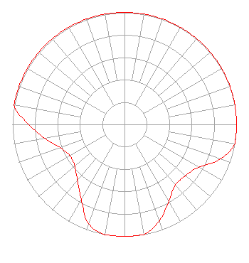 | ||||||||||||||||||
| Azimuth | Ratio | Azimuth | Ratio | Azimuth | Ratio | Azimuth | Ratio | ||||||||||||
| 0 | 1.000 | 10 | 1.000 | 20 | 1.000 | 30 | 1.000 | ||||||||||||
| 40 | 1.000 | 50 | 1.000 | 60 | 1.000 | 70 | 1.000 | ||||||||||||
| 80 | 1.000 | 90 | 1.000 | 100 | 1.000 | 110 | 0.908 | ||||||||||||
| 120 | 0.765 | 130 | 0.713 | 140 | 0.707 | 150 | 0.791 | ||||||||||||
| 160 | 0.913 | 170 | 1.000 | 180 | 1.000 | 190 | 1.000 | ||||||||||||
| 200 | 0.942 | 210 | 0.771 | 220 | 0.654 | 230 | 0.580 | ||||||||||||
| 240 | 0.562 | 250 | 0.609 | 260 | 0.722 | 270 | 0.857 | ||||||||||||
| 280 | 1.000 | 290 | 1.000 | 300 | 1.000 | 310 | 1.000 | ||||||||||||
| 320 | 1.000 | 330 | 1.000 | 340 | 1.000 | 350 | 1.000 | ||||||||||||
Structure Registration Number 1207386 Structure Type: GTOWER Registered To: American Towers LLC Structure Address: 13640 East County Road (202566) Edgar, IL County Name: Edgar County ASR Issued: 06/21/2017 Date Built: 09/21/1992 Site Elevation: 197.2 m (647 ft.) Structure Height: 91.4 m (300 ft.) Height Overall: 92 m (302 ft.) Overall Height AMSL: 289.2 m (949 ft.) FAA Determination: 06/19/2017 FAA Study #: 2017-AGL-7647-OE FAA Circular #: 70/7460-1L Paint & Light FAA Chapters: 4, 8, 12 PRIOR STUDY 1992-AGL-1081-OE 39-45-20.6 N 87-42-49.8 W (NAD 83) 39-45-20.5 N 87-42-49.7 W (Converted to NAD 27) |
2175 Highway 75 Suite 6 Blountville, TN 37617 Phone: 423-878-6279 Not-for-Profit | Title: Director And President Date: 11/09/2021 Application Certifier Appalachian Educational Communication Corporation 2175 Highway 75 Suite 6 Blountville, TN 37617 Applicant John Jason Bennett Fm Expansion Group, Llc 7107 South Yale #444 Tulsa, OK 74136 Managing Member | |||||||||||||||||