
FCCInfo.com
A Service of Cavell, Mertz & Associates, Inc.
(855) FCC-INFO
|
|
|
|
|
||||||||||||||||
|
|
W241DG Channel: 241D 96.1 MHz Rochester, New York Service: FX - A translator or application for a translator. Facility ID: 202122 Fac. Service: FX Programming Delivery Method: Unspecified Status: License Application Accepted: 11/16/2021 Application Granted: 12/09/2021 File Number: -0000168885 License Expires: 06/01/2022 Application Type: License To Cover FCC Website Links: LMS Facility Details This Application Other W241DG Applications Other W241DG Applications in CDBS Including Superseded Applications Mailing Address Correspondence for W241DG Correspondence related to application -0000168885 Service Contour - Open Street Map or USGS Map (60 dBu) Service Contour - KML / Google Earth (60 dBu) Facility Type: FM STATION Class: D, A Noncommercial educational operating with no more than 10W Site Location: 43-08-05.5 N 77-35-05.7 W (NAD 83) Site Location: 43-08-05.3 N 77-35-06.7 W (Converted to NAD 27) Effective Radiated Power: 0 kW Horiz. ; 0.099 kW Vert. Antenna Center HAAT: 0 m Antenna Center AMSL: 0 m Horiz.; 265.4 m Vert. Antenna Center HAG: 0 m Horiz.; 49 m Vert. Site Elevation: 216.4 m. (710 ft.) Height Overall*: 97.5 m (320 ft.) (* As Filed In This Application, may differ from ASR Data, Below.) Directional Antenna Antenna Make/Model: Scala FMVMP-2 Antenna ID: 61047 Polarization: H
| ||||||||||||||||||
| Antenna Data for Antenna Id: 61047 W241DG FX File: -0000168885 Scala - FMVMP-2 Service: FX | 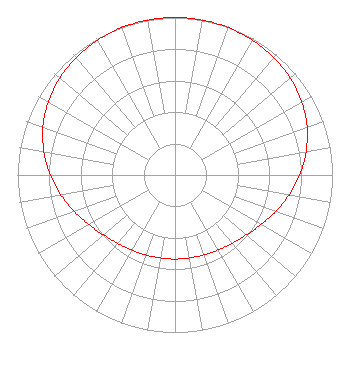 | ||||||||||||||||||
| Azimuth | Ratio | Azimuth | Ratio | Azimuth | Ratio | Azimuth | Ratio | ||||||||||||
| 0 | 1.000 | 10 | 0.999 | 20 | 0.995 | 30 | 0.987 | ||||||||||||
| 40 | 0.975 | 50 | 0.956 | 60 | 0.929 | 70 | 0.892 | ||||||||||||
| 80 | 0.845 | 90 | 0.792 | 100 | 0.735 | 110 | 0.679 | ||||||||||||
| 120 | 0.630 | 130 | 0.592 | 140 | 0.566 | 150 | 0.549 | ||||||||||||
| 160 | 0.540 | 170 | 0.535 | 180 | 0.534 | 190 | 0.535 | ||||||||||||
| 200 | 0.540 | 210 | 0.549 | 220 | 0.566 | 230 | 0.592 | ||||||||||||
| 240 | 0.630 | 250 | 0.679 | 260 | 0.735 | 270 | 0.792 | ||||||||||||
| 280 | 0.845 | 290 | 0.892 | 300 | 0.929 | 310 | 0.956 | ||||||||||||
| 320 | 0.975 | 330 | 0.987 | 340 | 0.995 | 350 | 0.999 | ||||||||||||
Structure Registration Number 1228608 Structure Type: LTOWER Registered To: American Towers LLC Structure Address: 1 Pinnacle Hill Road (221268) Rochester, NY County Name: Monroe County ASR Issued: 08/26/2021 Date Built: 06/09/2008 Site Elevation: 216.4 m (710 ft.) Structure Height: 82.3 m (270 ft.) Height Overall: 97.5 m (320 ft.) Overall Height AMSL: 313.9 m (1030 ft.) FAA Determination: 08/19/2021 FAA Study #: 2021-AEA-8972-OE FAA Circular #: 70/7460-1M Paint & Light FAA Chapters: 4, 8, 15 43-08-05.5 N 77-35-05.7 W (NAD 83) 43-08-05.3 N 77-35-06.7 W (Converted to NAD 27) |
7136 South Yale Avenue Suite 501 Tulsa, OK 74136 Phone: 918-664-4581 Limited Liability Company | Title: Vp, Technical Regulatory Affairs Date: 11/16/2021 Application Certifier IHM LICENSES, LLC Ihm Licenses, Llc 7136 South Yale Avenue Suite 501 Tulsa, OK 74136 Applicant Troy Langham Ihm Licenses, Llc 7136 South Yale Avenue Suite 501 Tulsa, OK 74136 VP, Technical Regulatory Affairs | |||||||||||||||||