
FCCInfo.com
A Service of Cavell, Mertz & Associates, Inc.
(855) FCC-INFO
|
|
WBWA from 06/16/2023 WBKV from 11/22/2019 WBKV from 06/13/1985 WBKV from 11/02/1984 |
|  |
|
|||||||||||||||
|
|
WBWA Channel: 210B1 89.9 MHz Buffalo, New York Service: FM - A full-service FM station or application. Facility ID: 20725 Fac. Service: FM Status: License Application Accepted: 12/03/2021 Application Granted: 01/07/2022 File Number: -0000176773 License Expires: 06/01/2022 Application Type: License To Cover FCC Website Links: LMS Facility Details This Application Other WBWA Applications Other WBWA Applications in CDBS Including Superseded Applications Mailing Address Correspondence for WBWA Correspondence related to application -0000176773 Service Contour - Open Street Map or USGS Map (60 dBu) Service Contour - KML / Google Earth (60 dBu) Public Inspection Files Facility Type: NON-COMMERCIAL EDUC. FM Class: B1, A Zone I or I-A station; with 6kW-25kW ERP and a class contour distance 28km-39km Site Location: 42-38-10.4 N 78-42-59.6 W (NAD 83) Site Location: 42-38-10.2 N 78-43-00.5 W (Converted to NAD 27) Effective Radiated Power: 3 kW Transmitter Output Power: 3.4 kW Antenna Center HAAT: 174 m (571 ft.) Antenna Center AMSL: 562 m (1844 ft.) Antenna Center HAG: 105 m (344 ft.) Site Elevation: 456.6 m. (1498 ft.) Height Overall*: 129.2 m (424 ft.) (* As Filed In This Application, may differ from ASR Data, Below.) Directional Antenna Antenna Make/Model: Shively 6025 Antenna ID: 45017 Polarization: | ||||||||||||||||||
| Antenna Data for Antenna Id: 45017 WBWA FM File: -0000176773 Shively - 6025 Service: FM | 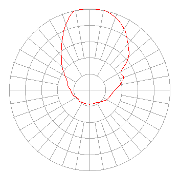 | ||||||||||||||||||
| Azimuth | Ratio | Azimuth | Ratio | Azimuth | Ratio | Azimuth | Ratio | ||||||||||||
| 0 | 1.000 | 10 | 1.000 | 20 | 0.950 | 30 | 0.863 | ||||||||||||
| 40 | 0.741 | 50 | 0.633 | 60 | 0.452 | 70 | 0.452 | ||||||||||||
| 80 | 0.387 | 90 | 0.316 | 100 | 0.282 | 110 | 0.262 | ||||||||||||
| 120 | 0.245 | 130 | 0.216 | 140 | 0.200 | 150 | 0.178 | ||||||||||||
| 160 | 0.178 | 170 | 0.178 | 180 | 0.178 | 190 | 0.178 | ||||||||||||
| 200 | 0.178 | 210 | 0.178 | 220 | 0.191 | 230 | 0.178 | ||||||||||||
| 240 | 0.188 | 250 | 0.212 | 260 | 0.224 | 270 | 0.236 | ||||||||||||
| 280 | 0.270 | 290 | 0.290 | 300 | 0.353 | 310 | 0.444 | ||||||||||||
| 320 | 0.543 | 330 | 0.683 | 340 | 0.860 | 350 | 1.000 | ||||||||||||
Structure Registration Number 1007352 Structure Type: TOWER Registered To: American Towers LLC Structure Address: 9084 Cole Rd (001003) Boston, NY County Name: Erie County ASR Issued: 01/15/2013 Date Built: 10/15/2004 Site Elevation: 456.6 m (1498 ft.) Structure Height: 109.7 m (360 ft.) Height Overall: 129.2 m (424 ft.) Overall Height AMSL: 585.8 m (1922 ft.) FAA Determination: 09/24/2004 FAA Study #: 2004-AEA-2749-OE FAA Circular #: 70/7460-1K Paint & Light FAA Chapters: 4, 8, 12 PRIOR STUDY 2003-AEA-838-OE 42-38-10.4 N 78-42-59.6 W (NAD 83) 42-38-10.2 N 78-43-00.5 W (Converted to NAD 27) |
5700 West Oaks Blvd. Rocklin, CA 95765 Phone: 916-251-1600 Not-for-Profit | Title: Ceo Date: 12/03/2021 Application Certifier EDUCATIONAL MEDIA FOUNDATION Educational Media Foundation 5700 West Oaks Blvd. Rocklin, CA 95765 Applicant Mary O'Conner, ESQ Wilkinson Barker Knauer, Llp 1800 M Street, N.w. Suite 800n Washington, DC 20036 James L Travis Educational Media Foundation 5700 West Oaks Blvd. Rocklin, CA 95765 FCC Compliance Engineer | |||||||||||||||||