
FCCInfo.com
A Service of Cavell, Mertz & Associates, Inc.
(855) FCC-INFO
|
|
WZTR from 06/07/1996 |
|
|
||||||||||||||||
|
|
WZTR Channel: 282A 104.3 MHz Dahlonega, Georgia Service: FM - A full-service FM station or application. Facility ID: 34319 Fac. Service: FM Status: License 73.215 Station Application Accepted: 12/21/2021 Application Granted: 03/10/2022 File Number: -0000177540 License Expires: 04/01/2028 Application Type: Minor Modification FCC Website Links: LMS Facility Details This Application Other WZTR Applications Other WZTR Applications in CDBS Including Superseded Applications Mailing Address Correspondence for WZTR Correspondence related to application -0000177540 Service Contour - Open Street Map or USGS Map (60 dBu) Service Contour - KML / Google Earth (60 dBu) Public Inspection Files Facility Type: NON-COMMERCIAL EDUC. FM Class: A, A Zone I; I-A; or II station; with 0.1kW-6kW ERP and a class contour distance <=28km Site Location: 34-29-56.3 N 84-08-31.7 W (NAD 83) Site Location: 34-29-56.0 N 84-08-32.0 W (Converted to NAD 27) Effective Radiated Power: 3.7 kW Transmitter Output Power: 1.38 kW Antenna Center HAAT: 127 m (417 ft.) Antenna Center AMSL: 602 m (1975 ft.) Antenna Center HAG: 90 m (295 ft.) Calculated Site Elevation: 512 m. (1680 ft.) Height Overall*: 92 m (302 ft.) (* As Filed In This Application, may differ from ASR Data, Below.) Directional Antenna Antenna Make/Model: Systems With Reliability Inc. FM3/3-DA Antenna ID: 64683 Polarization: | ||||||||||||||||||
| Antenna Data for Antenna Id: 64683 WZTR FM File: -0000177540 Systems With Reliability Inc. - FM3/3-DA Service: FM | 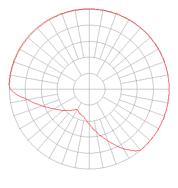 | ||||||||||||||||||
| Azimuth | Ratio | Azimuth | Ratio | Azimuth | Ratio | Azimuth | Ratio | ||||||||||||
| 0 | 1.000 | 10 | 1.000 | 20 | 1.000 | 30 | 1.000 | ||||||||||||
| 40 | 1.000 | 50 | 1.000 | 60 | 1.000 | 70 | 1.000 | ||||||||||||
| 80 | 1.000 | 90 | 1.000 | 100 | 1.000 | 110 | 1.000 | ||||||||||||
| 120 | 1.000 | 130 | 1.000 | 140 | 1.000 | 150 | 0.860 | ||||||||||||
| 160 | 0.690 | 170 | 0.550 | 180 | 0.440 | 190 | 0.360 | ||||||||||||
| 200 | 0.330 | 210 | 0.300 | 220 | 0.350 | 230 | 0.420 | ||||||||||||
| 240 | 0.500 | 250 | 0.620 | 260 | 0.780 | 270 | 0.980 | ||||||||||||
| 280 | 1.000 | 290 | 1.000 | 300 | 1.000 | 310 | 1.000 | ||||||||||||
| 320 | 1.000 | 330 | 1.000 | 340 | 1.000 | 350 | 1.000 | ||||||||||||
Structure Registration Number 1020865 Structure Type: TOWER Registered To: Augusta Radio Fellowship Institute, Inc Structure Address: 4 Km N Of Mc Kee Emma, GA County Name: Lumpkin County ASR Issued: 03/16/2022 Date Built: 12/01/1996 Site Elevation: 512 m (1680 ft.) Structure Height: 91.4 m (300 ft.) Height Overall: 92.3 m (303 ft.) Overall Height AMSL: 604.3 m (1983 ft.) FAA Determination: 06/12/1996 FAA Study #: 96-ASO-2604-OE FAA Circular #: 70/7460-1J Paint & Light FAA Chapters: 3, 4, 5, 13 34-29-56.0 N 84-08-32.0 W (NAD 83) 34-29-55.7 N 84-08-32.3 W (Converted to NAD 27) |
2278 Wortham Lane Groveton, GA 30813 Phone: 706-309-9609 Not-for-Profit | Title: President Date: 12/21/2021 Application Certifier GRADY W. TURNER Augusta Radio Fellowship Institute, Inc. 2278 Wortham Lane Groveton, GA 30813 Applicant JEFFREY DUKE SOUTHMAYD Southmayd & Miller 4 Ocean Ridge Blvd S Palm Coast, FL 32137 ATTORNEY | |||||||||||||||||
| |||||||||||||||||||