
FCCInfo.com
A Service of Cavell, Mertz & Associates, Inc.
(855) FCC-INFO
|
|
|
|
|
||||||||||||||||
|
|
Channel: 212A 90.3 MHz Dahlonega, Georgia Service: FM - A full-service FM station or application. Facility ID: 767745 Fac. Service: FM Status: Construction Permit Application Accepted: 02/14/2022 Application Granted: 10/20/2022 File Number: -0000166638 CP Expires: 10/20/2025 Application Type: Non-Commercial Educational Amendment FCC Website Links: LMS Facility Details This Application Other Applications Other Applications in CDBS Including Superseded Applications Mailing Address Correspondence for Correspondence related to application -0000166638 Service Contour - Open Street Map or USGS Map (60 dBu) Service Contour - KML / Google Earth (60 dBu) Facility Type: NON-COMMERCIAL EDUC. FM Class: A, A Zone I; I-A; or II station; with 0.1kW-6kW ERP and a class contour distance <=28km Site Location: 34-34-52.4 N 83-57-36.9 W (NAD 83) Site Location: 34-34-52.1 N 83-57-37.2 W (Converted to NAD 27) Effective Radiated Power: 3.2 kW Antenna Center HAAT: 43 m (141 ft.) Antenna Center AMSL: 544 m (1785 ft.) Antenna Center HAG: 85 m (279 ft.) Site Elevation: 459 m. (1506 ft.) Height Overall*: 93.9 m (308 ft.) (* As Filed In This Application, may differ from ASR Data, Below.) Directional Antenna Antenna Make/Model: None Antenna ID: 69-2019-08-06 Polarization: | ||||||||||||||||||
| Antenna Data for Antenna Id: 69-2019-08-06 FM File: -0000166638 None - Service: FM | 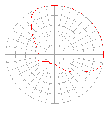 | ||||||||||||||||||
| Azimuth | Ratio | Azimuth | Ratio | Azimuth | Ratio | Azimuth | Ratio | ||||||||||||
| 0 | 1.000 | 10 | 1.000 | 20 | 1.000 | 30 | 1.000 | ||||||||||||
| 40 | 1.000 | 50 | 1.000 | 60 | 1.000 | 70 | 1.000 | ||||||||||||
| 80 | 1.000 | 90 | 1.000 | 100 | 1.000 | 110 | 0.899 | ||||||||||||
| 120 | 0.714 | 130 | 0.567 | 140 | 0.451 | 150 | 0.358 | ||||||||||||
| 160 | 0.284 | 170 | 0.226 | 180 | 0.179 | 190 | 0.178 | ||||||||||||
| 200 | 0.205 | 210 | 0.199 | 220 | 0.191 | 230 | 0.224 | ||||||||||||
| 240 | 0.282 | 250 | 0.355 | 260 | 0.324 | 270 | 0.338 | ||||||||||||
| 280 | 0.292 | 290 | 0.364 | 300 | 0.459 | 310 | 0.578 | ||||||||||||
| 320 | 0.727 | 330 | 0.915 | 340 | 1.000 | 350 | 1.000 | ||||||||||||
Structure Registration Number 1230509 Structure Type: TOWER Registered To: Crown Castle South LLC Structure Address: 95 Sandy Springs Road Dahloneca, GA County Name: Lumpkin County ASR Issued: 05/06/2016 Date Built: 06/19/2009 Site Elevation: 459 m (1506 ft.) Structure Height: 92 m (302 ft.) Height Overall: 93.9 m (308 ft.) Overall Height AMSL: 552.9 m (1814 ft.) FAA Determination: 10/20/2009 FAA Study #: 2009-ASO-6242-OE FAA Circular #: 70/7460-1K Paint & Light FAA Chapters: 4, 8, 12 PRIOR STUDY 2009-ASO-3116-OE 34-34-52.4 N 83-57-36.9 W (NAD 83) 34-34-52.1 N 83-57-37.2 W (Converted to NAD 27) |
7021 Pony Lake Road Dahlonega, GA 30533 Phone: 678-316-7309 Not-for-Profit | Title: President Date: 02/14/2022 Application Certifier Lumpkin Educational Broadcasting, Inc. 7021 Pony Lake Road Dahlonega, GA 30533 Applicant JEFFREY DUKE SOUTHMAYD Southmayd & Miller 4 Ocean Ridge Blvd S Palm Coast, FL 32137 ATTORNEY | |||||||||||||||||