
FCCInfo.com
A Service of Cavell, Mertz & Associates, Inc.
(855) FCC-INFO
|
|
|
|
|
||||||||||||||||
|
|
WLSO Channel: 218A 91.5 MHz Bowdon, Georgia Service: FM - A full-service FM station or application. Facility ID: 766075 Fac. Service: FM Status: Construction Permit Application Accepted: 02/28/2022 Application Granted: 09/16/2022 File Number: -0000167119 WLSO CP Expires: 09/16/2025 Application Type: Non-Commercial Educational Amendment FCC Website Links: LMS Facility Details This Application Other WLSO Applications Other WLSO Applications in CDBS Including Superseded Applications Mailing Address Correspondence for WLSO Correspondence related to application -0000167119 Service Contour - Open Street Map or USGS Map (60 dBu) Service Contour - KML / Google Earth (60 dBu) Public Inspection Files Facility Type: NON-COMMERCIAL EDUC. FM Class: A, A Zone I; I-A; or II station; with 0.1kW-6kW ERP and a class contour distance <=28km Site Location: 33-23-17.0 N 85-15-24.0 W (NAD 83) Site Location: 33-23-16.6 N 85-15-24.2 W (Converted to NAD 27) Effective Radiated Power: 2 kW Antenna Center HAAT: 108 m (354 ft.) Antenna Center AMSL: 429 m (1407 ft.) Antenna Center HAG: 47 m (154 ft.) Site Elevation: 382 m. (1253 ft.) Height Overall*: 70 m (230 ft.) (* As Filed In This Application, may differ from ASR Data, Below.) Directional Antenna Antenna Make/Model: None Antenna ID: 69-2019-08-06 Polarization: | ||||||||||||||||||
| Antenna Data for Antenna Id: 69-2019-08-06 WLSO FM File: -0000167119 None - Service: FM | 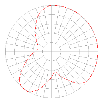 | ||||||||||||||||||
| Azimuth | Ratio | Azimuth | Ratio | Azimuth | Ratio | Azimuth | Ratio | ||||||||||||
| 0 | 1.000 | 10 | 1.000 | 20 | 1.000 | 30 | 1.000 | ||||||||||||
| 40 | 1.000 | 50 | 1.000 | 60 | 1.000 | 70 | 1.000 | ||||||||||||
| 80 | 1.000 | 90 | 1.000 | 100 | 1.000 | 110 | 1.000 | ||||||||||||
| 120 | 1.000 | 130 | 1.000 | 140 | 0.890 | 150 | 0.707 | ||||||||||||
| 160 | 0.562 | 170 | 0.446 | 180 | 0.555 | 190 | 0.699 | ||||||||||||
| 200 | 0.880 | 210 | 1.000 | 220 | 1.000 | 230 | 0.900 | ||||||||||||
| 240 | 0.715 | 250 | 0.568 | 260 | 0.451 | 270 | 0.358 | ||||||||||||
| 280 | 0.305 | 290 | 0.312 | 300 | 0.358 | 310 | 0.436 | ||||||||||||
| 320 | 0.549 | 330 | 0.668 | 340 | 0.831 | 350 | 0.933 | ||||||||||||
Structure Registration Number 1303876 Structure Type: LTOWER Registered To: Alltel Corporation Structure Address: 23317 Ga Hwy 100 Franklin, GA County Name: Heard County ASR Issued: 02/05/2019 Date Built: 09/18/2018 Site Elevation: 382.2 m (1254 ft.) Structure Height: 67 m (220 ft.) Height Overall: 70.1 m (230 ft.) Overall Height AMSL: 452.3 m (1484 ft.) FAA Determination: 09/07/2017 FAA Study #: 2017-ASO-6480-OE FAA Circular #: 70/7460-1L Paint & Light FAA Chapters: 4, 8, 12 Removed expiration date from determination. Scenario 1./jjs/case#635066 33-23-17.4 N 85-15-24.4 W (NAD 83) 33-23-17.0 N 85-15-24.6 W (Converted to NAD 27) |
1768 County Road 628 Roanoke, AL 36274 Phone: 256-449-2628 Not-for-Profit | Title: President Date: 02/28/2022 Application Certifier Living Springs Retreat 1768 County Road 628 Roanoke, AL 36274 Applicant Luke Rogers Luke Rogers Consulting 1435 Woodland Ridge Rd Odenville, AL 35120 DONALD MARTIN Law Office Of Donald E Martin Falls Church, VA 22041 Attorney | |||||||||||||||||