
FCCInfo.com
A Service of Cavell, Mertz & Associates, Inc.
(855) FCC-INFO
|
|
W205CP from 03/05/2013 W205CP from 10/04/2004 |
|
|
||||||||||||||||
|
|
W205CP Channel: 205D 88.9 MHz Winston-salem, North Carolina Service: FX - A translator or application for a translator. Facility ID: 154769 Fac. Service: FX Programming Delivery Method: Unspecified Status: License Application Accepted: 03/08/2022 Application Granted: 03/28/2022 File Number: -0000186149 License Expires: 12/01/2027 Application Type: License To Cover FCC Website Links: LMS Facility Details This Application Other W205CP Applications Other W205CP Applications in CDBS Including Superseded Applications Mailing Address Correspondence for W205CP Correspondence related to application -0000186149 Service Contour - Open Street Map or USGS Map (60 dBu) Service Contour - KML / Google Earth (60 dBu) Facility Type: NON-COMMERCIAL EDUC. FM Class: D, A Noncommercial educational operating with no more than 10W Site Location: 36-05-25.1 N 80-15-05.1 W (NAD 83) Site Location: 36-05-24.6 N 80-15-05.9 W (Converted to NAD 27) Effective Radiated Power: 0 kW Horiz. ; 0.25 kW Vert. Transmitter Output Power: 0.111 kW Antenna Center HAAT: 0 m Antenna Center AMSL: 0 m Horiz.; 354.8 m Vert. Antenna Center HAG: 0 m Horiz.; 82 m Vert. Site Elevation: 272.8 m. (895 ft.) Height Overall*: 105.2 m (345 ft.) (* As Filed In This Application, may differ from ASR Data, Below.) Directional Antenna Antenna Make/Model: Nicom BKY3P Antenna ID: 120512 Polarization: H
| ||||||||||||||||||
| Antenna Data for Antenna Id: 120512 W205CP FX File: -0000186149 Nicom - BKY3P Service: FX | 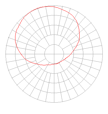 | ||||||||||||||||||
| Azimuth | Ratio | Azimuth | Ratio | Azimuth | Ratio | Azimuth | Ratio | ||||||||||||
| 0 | 0.970 | 10 | 0.930 | 20 | 0.900 | 30 | 0.850 | ||||||||||||
| 40 | 0.770 | 50 | 0.680 | 60 | 0.600 | 70 | 0.500 | ||||||||||||
| 80 | 0.410 | 90 | 0.350 | 100 | 0.300 | 110 | 0.260 | ||||||||||||
| 120 | 0.240 | 130 | 0.220 | 140 | 0.210 | 150 | 0.210 | ||||||||||||
| 160 | 0.210 | 170 | 0.210 | 180 | 0.210 | 190 | 0.220 | ||||||||||||
| 200 | 0.240 | 210 | 0.260 | 220 | 0.300 | 230 | 0.350 | ||||||||||||
| 240 | 0.410 | 250 | 0.500 | 260 | 0.600 | 270 | 0.680 | ||||||||||||
| 280 | 0.770 | 290 | 0.850 | 300 | 0.900 | 310 | 0.930 | ||||||||||||
| 320 | 0.970 | 330 | 0.990 | 340 | 1.000 | 350 | 0.990 | ||||||||||||
Structure Registration Number 1012292 Structure Type: LTOWER Registered To: American Towers, LLC Structure Address: 233 S Green St (306491) Winston Salem, NC County Name: Forsyth County ASR Issued: 02/07/2020 Date Built: 01/13/1995 Site Elevation: 272.8 m (895 ft.) Structure Height: 100.6 m (330 ft.) Height Overall: 105.2 m (345 ft.) Overall Height AMSL: 378 m (1240 ft.) FAA Determination: 03/24/2015 FAA Study #: 2015-ASO-2885-OE FAA Circular #: 70/7460-1J Paint & Light FAA Chapters: 4, 5, 6, 8, 13 OM&L to remain the same as prior study = A MED-DUAL SYSTEM 36-05-25.1 N 80-15-05.1 W (NAD 83) 36-05-24.6 N 80-15-05.9 W (Converted to NAD 27) |
5700 West Oaks Blvd. Rocklin, CA 95765 Phone: 916-251-1600 Not-for-Profit | Title: Ceo Date: 03/08/2022 Application Certifier EDUCATIONAL MEDIA FOUNDATION Educational Media Foundation 5700 West Oaks Blvd. Rocklin, CA 95765 Applicant Mary N O'Connor Wilkinson Barker Knauer, Llp 1800 M. Street, N.w. Suite 800n Washington, DC 20036 Esq. James L Travis Educational Media Foundation 5700 West Oaks Blvd. Rocklin, CA 95765 FCC COMPLIANCE ENGINEER | |||||||||||||||||