
FCCInfo.com
A Service of Cavell, Mertz & Associates, Inc.
(855) FCC-INFO
|
|
WCDG from 04/21/2010 |
|
|
||||||||||||||||
|
|
WCDG Channel: 204A 88.7 MHz Dahlonega, Georgia Service: FM - A full-service FM station or application. Facility ID: 172359 Fac. Service: FM Status: Construction Permit Application Accepted: 05/25/2022 Application Granted: 06/03/2022 File Number: -0000189071 WCDG CP Expires: 06/03/2025 Application Type: Minor Amendment FCC Website Links: LMS Facility Details This Application Other WCDG Applications Other WCDG Applications in CDBS Including Superseded Applications Mailing Address Correspondence for WCDG Correspondence related to application -0000189071 Service Contour - Open Street Map or USGS Map (60 dBu) Service Contour - KML / Google Earth (60 dBu) Public Inspection Files Facility Type: NON-COMMERCIAL EDUC. FM Class: A, A Zone I; I-A; or II station; with 0.1kW-6kW ERP and a class contour distance <=28km Site Location: 34-32-18.0 N 83-57-19.7 W (NAD 83) Site Location: 34-32-17.7 N 83-57-20.0 W (Converted to NAD 27) Effective Radiated Power: 0.57 kW Antenna Center HAAT: 79 m (259 ft.) Antenna Center AMSL: 523 m (1716 ft.) Antenna Center HAG: 61 m (200 ft.) Site Elevation: 462.1 m. (1516 ft.) Height Overall*: 76.5 m (251 ft.) (* As Filed In This Application, may differ from ASR Data, Below.) Directional Antenna Antenna Make/Model: None Antenna ID: 105373 Polarization: | ||||||||||||||||||
| Antenna Data for Antenna Id: 105373 WCDG FM File: -0000189071 None - Service: FM | 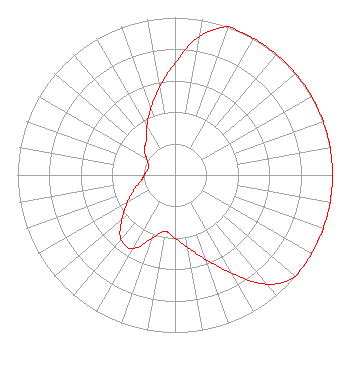 | ||||||||||||||||||
| Azimuth | Ratio | Azimuth | Ratio | Azimuth | Ratio | Azimuth | Ratio | ||||||||||||
| 0 | 0.713 | 10 | 0.895 | 20 | 1.000 | 30 | 1.000 | ||||||||||||
| 40 | 1.000 | 50 | 1.000 | 60 | 1.000 | 70 | 1.000 | ||||||||||||
| 80 | 1.000 | 90 | 1.000 | 100 | 1.000 | 110 | 1.000 | ||||||||||||
| 120 | 1.000 | 130 | 1.000 | 140 | 0.905 | 150 | 0.719 | ||||||||||||
| 160 | 0.571 | 170 | 0.467 | 180 | 0.402 | 190 | 0.363 | ||||||||||||
| 200 | 0.428 | 210 | 0.539 | 220 | 0.534 | 230 | 0.440 | ||||||||||||
| 240 | 0.350 | 250 | 0.278 | 260 | 0.221 | 270 | 0.195 | ||||||||||||
| 280 | 0.178 | 290 | 0.178 | 300 | 0.208 | 310 | 0.256 | ||||||||||||
| 320 | 0.284 | 330 | 0.358 | 340 | 0.450 | 350 | 0.566 | ||||||||||||
Structure Registration Number 1258278 Structure Type: TOWER Registered To: Cellco Partnership Structure Address: 49 Captain Mcdonald Road (rockhouse) Dahlonega, GA County Name: Lumpkin County ASR Issued: 06/14/2017 Date Built: 07/11/2007 Site Elevation: 462.1 m (1516 ft.) Structure Height: 74.6 m (245 ft.) Height Overall: 76.5 m (251 ft.) Overall Height AMSL: 538.6 m (1767 ft.) FAA Determination: 07/17/2007 FAA Study #: 2007-ASO-3710-OE FAA Circular #: 70/7460-1K Paint & Light FAA Chapters: 4, 8, 12 PRIOR STUDY 2007-ASO-1469-OE 34-32-18.0 N 83-57-19.7 W (NAD 83) 34-32-17.7 N 83-57-20.0 W (Converted to NAD 27) |
P.o. Box 998 Post Falls, ID 83877 Phone: 208-457-7140 Not-for-Profit | Title: President Date: 05/25/2022 Application Certifier LEGACY BROADCASTING, INC. Legacy Broadcasting, Inc. P.o. Box 998 Post Falls, ID 83877 Applicant Robert Moore Rcm Engineering 1908 Sweebriar Goshen, IN 46528 CONSULTING ENGINEER A. Wray Fitch, III Gammon & Grange, P.c. 1945 Old Gallows Road, Suite 650 Vienna, VA 22182 Attorney | |||||||||||||||||