
FCCInfo.com
A Service of Cavell, Mertz & Associates, Inc.
(855) FCC-INFO
|
|
|
|
|
||||||||||||||||
|
|
KTKL Channel: 203C2 88.5 MHz Stigler, Oklahoma Service: FM - A full-service FM station or application. Facility ID: 106473 Fac. Service: FM Status: License Application Accepted: 05/31/2022 Application Granted: 06/24/2022 File Number: -0000191913 License Expires: 06/01/2029 Application Type: License To Cover FCC Website Links: LMS Facility Details This Application Other KTKL Applications Other KTKL Applications in CDBS Including Superseded Applications Mailing Address Correspondence for KTKL Correspondence related to application -0000191913 Service Contour - Open Street Map or USGS Map (60 dBu) Service Contour - KML / Google Earth (60 dBu) Public Inspection Files Facility Type: NON-COMMERCIAL EDUC. FM Class: C2, A Zone II station; with 25kW-50kW ERP and a class contour distance 39km-52km Site Location: 35-08-25.3 N 95-21-25.8 W (NAD 83) Site Location: 35-08-24.9 N 95-21-24.9 W (Converted to NAD 27) Effective Radiated Power: 0 kW Horiz. ; 27 kW Vert. Transmitter Output Power: 2.01 kW Antenna Center HAAT: 0 m Horiz.; 189 m Vert. Antenna Center AMSL: 0 m Horiz.; 410 m Vert. Antenna Center HAG: 0 m Horiz.; 66 m Vert. Site Elevation: 343.8 m. (1128 ft.) Height Overall*: 81.4 m (267 ft.) (* As Filed In This Application, may differ from ASR Data, Below.) Directional Antenna Antenna Make/Model: Electronics Research Inc. P300-6B-DA Antenna ID: 132124 Polarization: H | ||||||||||||||||||
| Antenna Data for Antenna Id: 132124 KTKL FM File: -0000191913 Electronics Research Inc. - P300-6B-DA Service: FM | 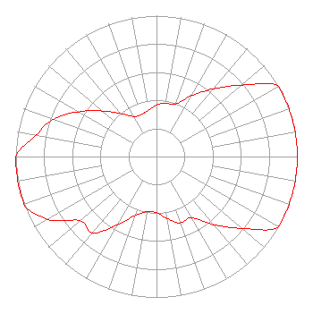 | ||||||||||||||||||
| Azimuth | Ratio | Azimuth | Ratio | Azimuth | Ratio | Azimuth | Ratio | ||||||||||||
| 0 | 0.366 | 5 | 0.378 | 10 | 0.386 | 20 | 0.396 | ||||||||||||
| 30 | 0.499 | 40 | 0.628 | 50 | 0.790 | 60 | 1.000 | ||||||||||||
| 70 | 1.000 | 80 | 1.000 | 90 | 1.000 | 100 | 1.000 | ||||||||||||
| 110 | 1.000 | 120 | 1.000 | 130 | 0.794 | 140 | 0.631 | ||||||||||||
| 150 | 0.501 | 160 | 0.501 | 170 | 0.447 | 180 | 0.398 | ||||||||||||
| 190 | 0.398 | 200 | 0.447 | 210 | 0.562 | 220 | 0.707 | ||||||||||||
| 230 | 0.708 | 240 | 0.891 | 250 | 1.000 | 260 | 1.000 | ||||||||||||
| 270 | 1.000 | 280 | 0.872 | 285 | 0.829 | 290 | 0.775 | ||||||||||||
| 295 | 0.710 | 300 | 0.633 | 310 | 0.503 | 320 | 0.399 | ||||||||||||
| 330 | 0.329 | 340 | 0.317 | 350 | 0.333 | ||||||||||||||
Structure Registration Number 1063890 Structure Type: LTOWER Registered To: American Towers LLC Structure Address: 1 Mi Ne Quinton, OK County Name: Pittsburg County ASR Issued: 01/05/2021 Date Built: 02/20/1991 Site Elevation: 343.8 m (1128 ft.) Structure Height: 79.8 m (262 ft.) Height Overall: 81.4 m (267 ft.) Overall Height AMSL: 425.2 m (1395 ft.) FAA Determination: 02/11/2019 FAA Study #: 2019-ASW-107-OE FAA Circular #: 70/7460-1G Paint & Light FAA Chapters: 3, 4, 5, 9 OM&L to remain the same as prior studies = PAINT/RED LIGHTS 35-08-25.3 N 95-21-25.8 W (NAD 83) 35-08-24.9 N 95-21-24.9 W (Converted to NAD 27) |
5700 West Oaks Boulevard Rocklin, CA 95765 Phone: 916-251-1600 Not-for-Profit | Title: Ceo Date: 05/31/2022 Application Certifier EDUCATIONAL MEDIA FOUNDATION Educational Media Foundation 5700 West Oaks Boulevard Rocklin, CA 95765 Applicant MARY O'Connor, ESQ Wilkinson Barker Knauer, Llp 1800 M. Street, N.w. Suite 800n Washington, DC 20036 Legal Representative JAMES L Travis Educational Media Foundation 5700 West Oaks Blvd Rocklin, CA 95765 FCC COMPLIANCE ENGINEER | |||||||||||||||||