
FCCInfo.com
A Service of Cavell, Mertz & Associates, Inc.
(855) FCC-INFO
|
|
K249EQ from 06/24/1999 K249EQ from 11/10/1998 |
|
|
||||||||||||||||
|
|
K249EQ Channel: 249D 97.7 MHz St. George, Utah Service: FX - A translator or application for a translator. Facility ID: 61382 Fac. Service: FX Programming Delivery Method: Unspecified Status: License Application Accepted: 06/13/2022 Application Granted: 07/06/2022 File Number: -0000193274 License Expires: 10/01/2029 Application Type: License To Cover FCC Website Links: LMS Facility Details This Application Other K249EQ Applications Other K249EQ Applications in CDBS Including Superseded Applications Mailing Address Correspondence for K249EQ Correspondence related to application -0000193274 Service Contour - Open Street Map or USGS Map (60 dBu) Service Contour - KML / Google Earth (60 dBu) Facility Type: FM STATION Class: D, A Noncommercial educational operating with no more than 10W Site Location: 37-03-49.2 N 113-34-27.9 W (NAD 83) Site Location: 37-03-49.3 N 113-34-25.1 W (Converted to NAD 27) Effective Radiated Power: 0.075 kW Transmitter Output Power: 0.12 kW Antenna Center HAAT: 37.2 m Horiz.; 0 m Vert. Antenna Center AMSL: 961.6 m (3155 ft.) Antenna Center HAG: 10.6 m (35 ft.) Site Elevation: 951 m. (3120 ft.) Height Overall*: 33.5 m (110 ft.) (* As Filed In This Application, may differ from ASR Data, Below.) Directional Antenna Antenna Make/Model: Bext TFC2K Antenna ID: 113935 Polarization: H
| ||||||||||||||||||
| Antenna Data for Antenna Id: 113935 K249EQ FX File: -0000193274 Bext - TFC2K Service: FX | 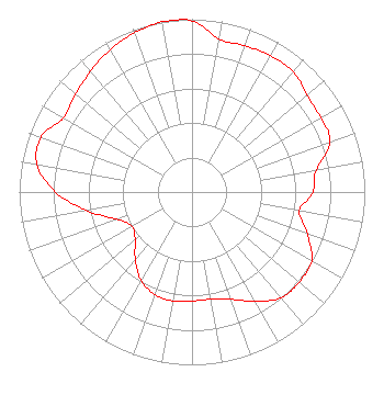 | ||||||||||||||||||
| Azimuth | Ratio | Azimuth | Ratio | Azimuth | Ratio | Azimuth | Ratio | ||||||||||||
| 0 | 0.990 | 10 | 0.900 | 20 | 0.900 | 30 | 0.910 | ||||||||||||
| 40 | 0.910 | 50 | 0.870 | 60 | 0.860 | 70 | 0.850 | ||||||||||||
| 80 | 0.730 | 90 | 0.700 | 100 | 0.630 | 110 | 0.710 | ||||||||||||
| 120 | 0.800 | 130 | 0.810 | 140 | 0.800 | 150 | 0.730 | ||||||||||||
| 160 | 0.660 | 170 | 0.630 | 180 | 0.630 | 190 | 0.640 | ||||||||||||
| 200 | 0.630 | 210 | 0.590 | 220 | 0.510 | 230 | 0.430 | ||||||||||||
| 240 | 0.400 | 250 | 0.460 | 260 | 0.620 | 270 | 0.790 | ||||||||||||
| 280 | 0.910 | 290 | 0.930 | 300 | 0.860 | 310 | 0.880 | ||||||||||||
| 320 | 0.913 | 330 | 0.950 | 340 | 0.980 | 350 | 1.000 | ||||||||||||
Structure Registration Number 1240386 [ASR Heights Differ from K249EQ Application] Structure Type: LTOWER Registered To: American Towers LLC Structure Address: Webb Hill Hillrise Dr. (210222) Saint George, UT County Name: Washington County ASR Issued: 11/21/2022 Date Built: 03/23/2004 Site Elevation: 953.7 m (3129 ft.) Structure Height: 30.5 m (100 ft.) Height Overall: 33.5 m (110 ft.) Overall Height AMSL: 987.2 m (3239 ft.) FAA Determination: 11/07/2022 FAA Study #: 2022-ANM-6507-OE Paint & Light FAA Chapters: NONE PRIOR STUDY 2015-ANM-2841-OE 37-03-49.2 N 113-34-27.9 W (NAD 83) 37-03-49.3 N 113-34-25.1 W (Converted to NAD 27) |
1 Manhattanville Road Suite 202 Purchase, NY 10577 Phone: 203-861-0900 Limited Liability Company | Title: Vp Date: 06/13/2022 Application Certifier CCR-ST. GEORGE IV, LLC Ccr-st. George Iv, Llc 7400 E. Orchard Road Suite 2800n Greenwood Village, CO 80111 Applicant Sally A. Buckman Lerman Senter Pllc 2001 L Street, Nw, Suite 400 Washington, DC 20036 Attorney Robert M Smith, Jr R.m. Smith Associates 10920b Crown Colony Dr. Austin, TX 78747 Technical Consultant | |||||||||||||||||