
FCCInfo.com
A Service of Cavell, Mertz & Associates, Inc.
(855) FCC-INFO
|
|
W231EF from 12/08/2016 W231EF from 08/08/2016 W231EF from 04/09/2004 |
|
|
||||||||||||||||
|
|
W231EF Channel: 231D 94.1 MHz Toledo, Ohio Service: FX - A translator or application for a translator. Facility ID: 138974 Fac. Service: FX Programming Delivery Method: Unspecified Status: License Application Accepted: 06/24/2022 Application Granted: 10/13/2022 File Number: -0000193183 License Expires: 10/01/2028 Application Type: Amendment FCC Website Links: LMS Facility Details This Application Other W231EF Applications Other W231EF Applications in CDBS Including Superseded Applications Mailing Address Correspondence for W231EF Correspondence related to application -0000193183 Service Contour - Open Street Map or USGS Map (60 dBu) Service Contour - KML / Google Earth (60 dBu) Facility Type: FM STATION Class: D, A Noncommercial educational operating with no more than 10W Site Location: 41-38-48.7 N 83-36-17.7 W (NAD 83) Site Location: 41-38-48.5 N 83-36-17.9 W (Converted to NAD 27) Effective Radiated Power: 0.14 kW Transmitter Output Power: 0.028 kW Antenna Center HAAT: 0 m Antenna Center AMSL: 312.8 m (1026 ft.) Antenna Center HAG: 126 m (413 ft.) Site Elevation: 186.8 m. (613 ft.) Height Overall*: 134.2 m (440 ft.) (* As Filed In This Application, may differ from ASR Data, Below.) Directional Antenna Antenna Make/Model: Nicom BKG-77 Antenna ID: 126012 Polarization: H
| ||||||||||||||||||
| Antenna Data for Antenna Id: 126012 W231EF FX File: -0000193183 Nicom - BKG-77 Service: FX | 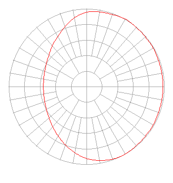 | ||||||||||||||||||
| Azimuth | Ratio | Azimuth | Ratio | Azimuth | Ratio | Azimuth | Ratio | ||||||||||||
| 0 | 0.953 | 10 | 0.973 | 20 | 0.983 | 30 | 1.000 | ||||||||||||
| 40 | 0.992 | 50 | 0.988 | 60 | 0.988 | 70 | 0.983 | ||||||||||||
| 80 | 0.983 | 90 | 0.983 | 100 | 0.983 | 110 | 0.983 | ||||||||||||
| 120 | 0.988 | 130 | 0.988 | 140 | 0.992 | 150 | 1.000 | ||||||||||||
| 160 | 0.991 | 170 | 0.963 | 180 | 0.923 | 190 | 0.862 | ||||||||||||
| 200 | 0.797 | 210 | 0.731 | 220 | 0.676 | 230 | 0.628 | ||||||||||||
| 240 | 0.594 | 250 | 0.571 | 260 | 0.558 | 270 | 0.553 | ||||||||||||
| 280 | 0.558 | 290 | 0.571 | 300 | 0.594 | 310 | 0.628 | ||||||||||||
| 320 | 0.682 | 330 | 0.738 | 340 | 0.815 | 350 | 0.897 | ||||||||||||
Structure Registration Number 1054371 Structure Type: GTOWER Registered To: American Towers LLC Structure Address: Ne Of Westwood Ave. & Nebraska Ave. (westwood 1 Of 2 #50923) Toledo, OH County Name: Lucas County ASR Issued: 05/16/2013 Date Built: 05/10/2002 Site Elevation: 186.8 m (613 ft.) Structure Height: 132.6 m (435 ft.) Height Overall: 134.2 m (440 ft.) Overall Height AMSL: 321 m (1053 ft.) FAA Determination: 04/29/2013 FAA Study #: 2013-AGL-3740-OE FAA Circular #: 70/7460-1K Paint & Light FAA Chapters: 4, 8, 12 OM&L to remain the same as prior study = A MED-DUAL SYSTEM 41-38-48.7 N 83-36-17.7 W (NAD 83) 41-38-48.5 N 83-36-17.9 W (Converted to NAD 27) |
680 Barclay Boulevard Lincolnshire, IL 60069 Phone: 877-291-0123 Not-for-Profit | Title: Llc Member Date: 06/24/2022 Application Certifier FUSION RADIO, LLC Fusion Radio, Llc 3535 North Harlem Avenue #301 Chicago, IL 60634 Applicant James L Oyster Law Offices Of James L. Oyster 1926 Canterbury Court # 303 Lynchburg, VA 24503 David J Doherty Skywaves Consulting Llc Portland, OR 97212 Technical Consultant | |||||||||||||||||