
FCCInfo.com
A Service of Cavell, Mertz & Associates, Inc.
(855) FCC-INFO
|
|
W271DQ from 09/14/2022 W271DQ from 12/30/1997 |
|
|
||||||||||||||||
|
|
W271DQ Channel: 271D 102.1 MHz Baraboo, Wisconsin Service: FX - A translator or application for a translator. Facility ID: 86124 Fac. Service: FX Programming Delivery Method: Unspecified Status: License Application Accepted: 08/16/2022 Application Granted: 09/14/2022 File Number: -0000197740 License Expires: 12/01/2028 Application Type: License To Cover FCC Website Links: LMS Facility Details This Application Other W271DQ Applications Other W271DQ Applications in CDBS Including Superseded Applications Mailing Address Correspondence for W271DQ Correspondence related to application -0000197740 Service Contour - Open Street Map or USGS Map (60 dBu) Service Contour - KML / Google Earth (60 dBu) Facility Type: FM STATION Class: D, A Noncommercial educational operating with no more than 10W Site Location: 43-25-40.0 N 89-39-14.0 W (NAD 83) Site Location: 43-25-40.1 N 89-39-13.6 W (Converted to NAD 27) Effective Radiated Power: 0.25 kW Antenna Center HAAT: -22 m Horiz.; 0 m Vert. Antenna Center AMSL: 667.4 m (2190 ft.) Antenna Center HAG: 181.4 m (595 ft.) Site Elevation: 486 m. (1594 ft.) Height Overall*: 199 m (653 ft.) (* As Filed In This Application, may differ from ASR Data, Below.) Directional Antenna Antenna Make/Model: Nicom BKG1P/3L(DA)(Slant45) Antenna ID: 1009939 Polarization: H
| ||||||||||||||||||
| Antenna Data for Antenna Id: 1009939 W271DQ FX File: -0000197740 Nicom - BKG1P/3L(DA)(Slant45) Service: FX | 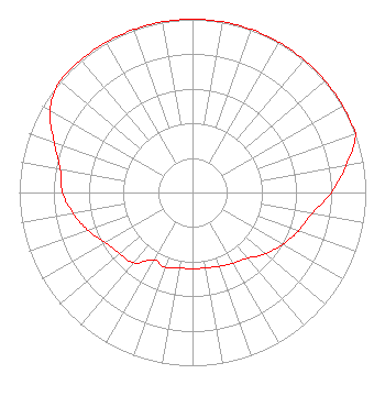 | ||||||||||||||||||
| Azimuth | Ratio | Azimuth | Ratio | Azimuth | Ratio | Azimuth | Ratio | ||||||||||||
| 0 | 1.000 | 10 | 1.000 | 20 | 1.000 | 30 | 1.000 | ||||||||||||
| 40 | 1.000 | 50 | 1.000 | 60 | 1.000 | 70 | 1.000 | ||||||||||||
| 80 | 0.900 | 90 | 0.800 | 100 | 0.700 | 110 | 0.650 | ||||||||||||
| 120 | 0.600 | 130 | 0.550 | 140 | 0.495 | 150 | 0.470 | ||||||||||||
| 160 | 0.453 | 170 | 0.442 | 180 | 0.440 | 190 | 0.443 | ||||||||||||
| 200 | 0.460 | 210 | 0.450 | 220 | 0.530 | 230 | 0.550 | ||||||||||||
| 240 | 0.580 | 250 | 0.640 | 260 | 0.700 | 270 | 0.750 | ||||||||||||
| 280 | 0.775 | 290 | 0.850 | 300 | 0.950 | 310 | 1.000 | ||||||||||||
| 320 | 1.000 | 330 | 1.000 | 340 | 1.000 | 350 | 1.000 | ||||||||||||
Structure Registration Number 1050736 Structure Type: GTOWER Registered To: American Towers LLC Structure Address: 13453 Tower Rd (273579) Baraboo, WI County Name: Sauk County ASR Issued: 03/31/2023 Date Built: 01/01/1947 Site Elevation: 486 m (1594 ft.) Structure Height: 198 m (650 ft.) Height Overall: 199 m (653 ft.) Overall Height AMSL: 685 m (2247 ft.) FAA Determination: 04/28/2017 FAA Study #: 2017-AGL-7781-OE FAA Circular #: 70/7460-1L Paint & Light FAA Chapters: 4, 8, 12 PRIOR STUDY 2013-AGL-8752-OE 43-25-40.0 N 89-39-14.0 W (NAD 83) 43-25-40.1 N 89-39-13.6 W (Converted to NAD 27) |
West Bend, WI 53095 Phone: 608-742-2544 Corporation | Title: President Date: 08/16/2022 Application Certifier MAGNUM COMMUNICATIONS, INC. Magnum Communications, Inc. West Bend, WI 53095 Applicant Justin Asher Asher Broadcast Consulting, Llc 579 Babcock Road Bronson, MI 49028-9347 Technical Consultant John C Trent, Esq. Putbrese, Hunsaker And Trent, Pc 200 South Church Street Woodstock, VA 22664 | |||||||||||||||||