
FCCInfo.com
A Service of Cavell, Mertz & Associates, Inc.
(855) FCC-INFO
|
|
|
|
|
||||||||||||||||
|
|
K296GT Channel: 296D 107.1 MHz Tucson, Arizona Service: FX - A translator or application for a translator. Facility ID: 147206 Fac. Service: FX Programming Delivery Method: Unspecified Status: Construction Permit Application Accepted: 12/01/2022 Application Granted: 02/07/2023 File Number: -0000203147 K296GT CP Expires: 02/06/2026 Application Type: Minor Amendment FCC Website Links: LMS Facility Details This Application Other K296GT Applications Other K296GT Applications in CDBS Including Superseded Applications Mailing Address Correspondence for K296GT Correspondence related to application -0000203147 Service Contour - Open Street Map or USGS Map (60 dBu) Service Contour - KML / Google Earth (60 dBu) Facility Type: NON-COMMERCIAL EDUC. FM Class: D, A Noncommercial educational operating with no more than 10W Site Location: 32-14-56.4 N 111-07-00.5 W (NAD 83) Site Location: 32-14-56.1 N 111-06-58.1 W (Converted to NAD 27) Effective Radiated Power: 0 kW Horiz. ; 0.25 kW Vert. Antenna Center HAAT: 0 m Antenna Center AMSL: 0 m Horiz.; 1350 m Vert. Antenna Center HAG: 0 m Horiz.; 27.2 m Vert. Site Elevation: 1322.8 m. (4340 ft.) Height Overall*: 68.6 m (225 ft.) (* As Filed In This Application, may differ from ASR Data, Below.) Directional Antenna Antenna Make/Model: Scala CL-FM-V Antenna ID: 0 Polarization: H
| ||||||||||||||||||
| Antenna Data for Antenna Id: 0 K296GT FX File: -0000203147 Scala - CL-FM-V Service: FX | 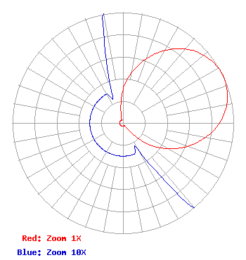 | ||||||||||||||||||
| Azimuth | Ratio | Azimuth | Ratio | Azimuth | Ratio | Azimuth | Ratio | ||||||||||||
| 0 | 0.300 | 10 | 0.468 | 20 | 0.618 | 30 | 0.756 | ||||||||||||
| 40 | 0.873 | 50 | 0.952 | 60 | 0.993 | 65 | 1.000 | ||||||||||||
| 70 | 0.993 | 80 | 0.952 | 90 | 0.873 | 100 | 0.756 | ||||||||||||
| 110 | 0.618 | 120 | 0.468 | 130 | 0.300 | 140 | 0.110 | ||||||||||||
| 150 | 0.030 | 160 | 0.030 | 170 | 0.030 | 180 | 0.030 | ||||||||||||
| 190 | 0.030 | 200 | 0.030 | 210 | 0.030 | 220 | 0.030 | ||||||||||||
| 230 | 0.030 | 240 | 0.030 | 250 | 0.030 | 260 | 0.030 | ||||||||||||
| 270 | 0.030 | 280 | 0.030 | 290 | 0.030 | 300 | 0.030 | ||||||||||||
| 310 | 0.030 | 320 | 0.030 | 330 | 0.030 | 340 | 0.030 | ||||||||||||
| 350 | 0.110 | ||||||||||||||||||
Structure Registration Number 1218277 Structure Type: GTOWER Registered To: American Towers LLC Structure Address: 7120 W. Lost Canyon Dr. (tucson Mtn, T2 #8159--dsm) South Tucson, AZ County Name: Pima County ASR Issued: 08/01/2017 Date Built: 01/26/1998 Site Elevation: 1322.8 m (4340 ft.) Structure Height: 42.7 m (140 ft.) Height Overall: 68.6 m (225 ft.) Overall Height AMSL: 1391.4 m (4565 ft.) FAA Determination: 07/12/2017 FAA Study #: 2017-AWP-6306-OE Paint & Light FAA Chapters: NONE Removed expiration date from determination. Scenario 1./jjs/case#635066 32-14-56.4 N 111-07-00.5 W (NAD 83) 32-14-56.1 N 111-06-58.1 W (Converted to NAD 27) |
4111 Plains Blvd Amarillo, TX 79106 Phone: 806-353-1488 Not-for-Profit | Title: President Date: 12/01/2022 Application Certifier RADIO BY GRACE, INC. Radio By Grace, Inc. 4111 Plains Blvd Amarillo, TX 79106 Applicant Jim Turvaville Turbo Tech Service 360 Patton Mobeetie, TX 79061 | |||||||||||||||||