
FCCInfo.com
A Service of Cavell, Mertz & Associates, Inc.
(855) FCC-INFO
|
|
|
|  |
|
|||||||||||||||
|
|
KNTU Channel: 201C1 88.1 MHz Mckinney, Texas Service: FS - A full service FM station auxiliary transmitting antenna or application. Facility ID: 69003 Fac. Service: FM Status: Construction Permit Application Accepted: 12/08/2022 Application Granted: 01/23/2023 File Number: -0000204917 KNTU CP Expires: 01/23/2026 Application Type: Minor Modification FCC Website Links: LMS Facility Details This Application Other KNTU Applications Other KNTU Applications in CDBS Including Superseded Applications Mailing Address Correspondence for KNTU Correspondence related to application -0000204917 Service Contour - Open Street Map or USGS Map (60 dBu) Service Contour - KML / Google Earth (60 dBu) Public Inspection Files History Cards for KNTU Facility Type: NON-COMMERCIAL EDUC. FM Class: C1, A Zone II station; with 50kW-100kW ERP and a class contour distance 52km-72km Site Location: 33-17-24.0 N 97-08-11.0 W (NAD 83) Site Location: 33-17-23.6 N 97-08-10.0 W (Converted to NAD 27) Effective Radiated Power: 79 kW Antenna Center HAAT: 111 m (364 ft.) Antenna Center AMSL: 305.4 m (1002 ft.) Antenna Center HAG: 116 m (381 ft.) Site Elevation: 189.4 m. (621 ft.) Height Overall*: 152.1 m (499 ft.) (* As Filed In This Application, may differ from ASR Data, Below.) Directional Antenna Antenna Make/Model: None Antenna ID: 13843 Polarization: | ||||||||||||||||||
| Antenna Data for Antenna Id: 13843 KNTU FS File: -0000204917 None - Service: FS | 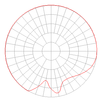 | ||||||||||||||||||
| Azimuth | Ratio | Azimuth | Ratio | Azimuth | Ratio | Azimuth | Ratio | ||||||||||||
| 0 | 1.000 | 10 | 1.000 | 20 | 1.000 | 30 | 1.000 | ||||||||||||
| 40 | 1.000 | 50 | 1.000 | 60 | 1.000 | 70 | 1.000 | ||||||||||||
| 80 | 1.000 | 90 | 0.998 | 100 | 0.990 | 110 | 0.950 | ||||||||||||
| 120 | 0.880 | 130 | 0.800 | 140 | 0.730 | 150 | 0.700 | ||||||||||||
| 160 | 0.730 | 170 | 0.920 | 180 | 0.820 | 190 | 0.650 | ||||||||||||
| 200 | 0.820 | 210 | 1.000 | 220 | 1.000 | 230 | 1.000 | ||||||||||||
| 240 | 1.000 | 250 | 1.000 | 260 | 1.000 | 270 | 1.000 | ||||||||||||
| 280 | 1.000 | 290 | 1.000 | 300 | 1.000 | 310 | 1.000 | ||||||||||||
| 320 | 1.000 | 330 | 1.000 | 340 | 1.000 | 350 | 1.000 | ||||||||||||
Structure Registration Number 1053099 Structure Type: GTOWER Registered To: UNIVERSITY OF NORTH TEXAS Structure Address: 8.3 Km N Of Courthouse .16 Km W Of 2164 Denton, TX County Name: Denton County ASR Issued: 03/13/2023 Date Built: 03/13/2023 Site Elevation: 189.4 m (621 ft.) Structure Height: 151.4 m (497 ft.) Height Overall: 152.1 m (499 ft.) Overall Height AMSL: 341.5 m (1120 ft.) FAA Determination: 03/09/2023 FAA Study #: 2022-ASW-15084-OE FAA Circular #: 70/7460-1M Paint & Light FAA Chapters: 3, 4, 5, 15 PRIOR STUDY 1986-ASW-1915-OE 33-17-24.0 N 97-08-11.0 W (NAD 83) 33-17-23.6 N 97-08-10.0 W (Converted to NAD 27) |
1155 Union Circle #310500 Denton, TX 76203 Phone: 940-565-2055 Government Entity | Title: Vice President For Finance And Cfo Date: 12/08/2022 Application Certifier University Of North Texas 1155 Union Circle #310881 Denton, TX 76203 Applicant Robert J Clinton Cavell, Mertz & Associates, Inc. 7724 Donegan Drive Manassas, VA 20109 TECHNICAL CONSULTANT Barry Persh Gray Miller Persh Llp 2233 Wisconsin Avenue Nw Suite 226 Washington, DC 20007 | |||||||||||||||||
|
| ||||||||||||||||||