
FCCInfo.com
A Service of Cavell, Mertz & Associates, Inc.
(855) FCC-INFO
|
|
K297BB from 05/26/2004 |
|
|
||||||||||||||||
|
|
K297BB Channel: 297D 107.3 MHz Edmond, Oklahoma Service: FX - A translator or application for a translator. Facility ID: 156917 Fac. Service: FX Programming Delivery Method: Unspecified Status: Construction Permit Application Accepted: 01/05/2023 Application Granted: 01/23/2023 File Number: -0000206324 K297BB CP Expires: 01/22/2026 Application Type: Minor Modification FCC Website Links: LMS Facility Details This Application Other K297BB Applications Other K297BB Applications in CDBS Including Superseded Applications Mailing Address Correspondence for K297BB Correspondence related to application -0000206324 Service Contour - Open Street Map or USGS Map (60 dBu) Service Contour - KML / Google Earth (60 dBu) Facility Type: NON-COMMERCIAL EDUC. FM Class: D, A Noncommercial educational operating with no more than 10W Site Location: 35-34-18.4 N 97-29-09.0 W (NAD 83) Site Location: 35-34-18.2 N 97-29-07.9 W (Converted to NAD 27) Effective Radiated Power: 0.13 kW Antenna Center HAAT: 0 m Antenna Center AMSL: 612.4 m (2009 ft.) Antenna Center HAG: 250 m (820 ft.) Site Elevation: 362.4 m. (1189 ft.) Height Overall*: 257.6 m (845 ft.) (* As Filed In This Application, may differ from ASR Data, Below.) Directional Antenna Antenna Make/Model: Nicom BKG77-2 Antenna ID: 0 Polarization: H
| ||||||||||||||||||
| Antenna Data for Antenna Id: 0 K297BB FX File: -0000206324 Nicom - BKG77-2 Service: FX | 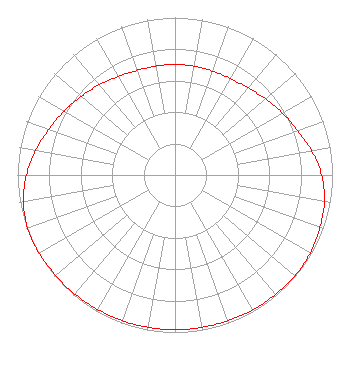 | ||||||||||||||||||
| Azimuth | Ratio | Azimuth | Ratio | Azimuth | Ratio | Azimuth | Ratio | ||||||||||||
| 0 | 0.702 | 10 | 0.702 | 20 | 0.702 | 30 | 0.707 | ||||||||||||
| 40 | 0.722 | 50 | 0.752 | 60 | 0.787 | 70 | 0.827 | ||||||||||||
| 80 | 0.881 | 90 | 0.931 | 100 | 0.963 | 110 | 0.978 | ||||||||||||
| 120 | 0.991 | 130 | 0.996 | 140 | 0.990 | 150 | 0.988 | ||||||||||||
| 160 | 0.985 | 170 | 0.983 | 180 | 0.983 | 190 | 0.983 | ||||||||||||
| 200 | 0.983 | 210 | 0.985 | 220 | 0.988 | 230 | 0.990 | ||||||||||||
| 240 | 0.996 | 250 | 0.995 | 260 | 0.977 | 270 | 0.943 | ||||||||||||
| 280 | 0.898 | 290 | 0.852 | 300 | 0.812 | 310 | 0.777 | ||||||||||||
| 320 | 0.747 | 330 | 0.721 | 340 | 0.706 | 350 | 0.702 | ||||||||||||
Structure Registration Number 1244114 Structure Type: TOWER Registered To: Vertical Bridge Towers III, LLC Structure Address: 1601 Ne 101st St Oklahoma City, OK County Name: Oklahoma County ASR Issued: 10/30/2019 Date Built: 07/13/2005 Site Elevation: 362.4 m (1189 ft.) Structure Height: 251.6 m (825 ft.) Height Overall: 257.6 m (845 ft.) Overall Height AMSL: 620 m (2034 ft.) FAA Determination: 02/18/2004 FAA Study #: 2004-ASW-377-OE FAA Circular #: 70/7460-1J Paint & Light FAA Chapters: 3, 4, 5, 13 PRIOR STUDY 2003-ASW-6943-OE 35-34-18.4 N 97-29-09.0 W (NAD 83) 35-34-18.2 N 97-29-07.9 W (Converted to NAD 27) |
880 E 1545 Rd Calvin, OK 74531 Phone: 580-892-3753 Not-for-Profit | Title: President Date: 01/05/2023 Application Certifier RUSSELL MINISTRIES, INC Russell Ministries, Inc 880 E 1545 Rd Calvin, OK 74531 Applicant Gene Wisniewski Genew2012 1472 E 3100 S Wendell, ID 83355 CONSULTING ENGINEER Mike Russell Russell Ministries, Inc. 880 E 1545 Rd Calvin, OK 74531 President | |||||||||||||||||