
FCCInfo.com
A Service of Cavell, Mertz & Associates, Inc.
(855) FCC-INFO
|
|
KVST from 09/08/1998 KVST from 12/03/1990 |
|  |
|
||||||||||||||||||
|
|
KVST Channel: 259C3 99.7 MHz Huntsville, Texas Service: FS - A full service FM station auxiliary transmitting antenna or application. Facility ID: 26858 Fac. Service: FM Status: License Application Accepted: 01/26/2023 Application Granted: 07/11/2023 File Number: -0000208102 License Expires: 08/01/2029 Application Type: License To Cover FCC Website Links: LMS Facility Details This Application Other KVST Applications Other KVST Applications in CDBS Including Superseded Applications Mailing Address Correspondence for KVST Correspondence related to application -0000208102 Service Contour - Open Street Map or USGS Map (60 dBu) Service Contour - KML / Google Earth (60 dBu) Public Inspection Files Facility Type: FM STATION Class: C3, A Zone II station; with 6kW-25kW ERP and a class contour distance 28km-39km Site Location: 30-26-55.4 N 95-31-47.3 W (NAD 83) Site Location: 30-26-54.7 N 95-31-46.5 W (Converted to NAD 27) Effective Radiated Power: 6 kW Antenna Center HAAT: 126 m (413 ft.) Antenna Center AMSL: 202 m (663 ft.) Antenna Center HAG: 120 m (394 ft.) Site Elevation: 82 m. (269 ft.) Height Overall*: 129 m (423 ft.) (* As Filed In This Application, may differ from ASR Data, Below.) Directional Antenna Antenna Make/Model: Dielectric DCRH-2E Antenna ID: 1010407 Polarization: | |||||||||||||||||||||
| Antenna Data for Antenna Id: 1010407 KVST FS File: -0000208102 Dielectric - DCRH-2E Service: FS | 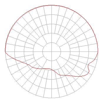 | |||||||||||||||||||||
| Azimuth | Ratio | Azimuth | Ratio | Azimuth | Ratio | Azimuth | Ratio | |||||||||||||||
| 0 | 1.000 | 10 | 1.000 | 20 | 1.000 | 30 | 1.000 | |||||||||||||||
| 40 | 1.000 | 50 | 1.000 | 60 | 1.000 | 70 | 1.000 | |||||||||||||||
| 80 | 1.000 | 90 | 1.000 | 100 | 0.947 | 110 | 0.845 | |||||||||||||||
| 120 | 0.920 | 130 | 0.830 | 140 | 0.685 | 150 | 0.590 | |||||||||||||||
| 160 | 0.540 | 170 | 0.440 | 180 | 0.387 | 190 | 0.369 | |||||||||||||||
| 200 | 0.390 | 210 | 0.430 | 220 | 0.475 | 230 | 0.530 | |||||||||||||||
| 240 | 0.570 | 250 | 0.670 | 260 | 0.840 | 270 | 1.000 | |||||||||||||||
| 280 | 1.000 | 290 | 1.000 | 300 | 1.000 | 310 | 1.000 | |||||||||||||||
| 320 | 1.000 | 330 | 1.000 | 340 | 1.000 | 350 | 1.000 | |||||||||||||||
Structure Registration Number 1279900 Structure Type: TOWER Registered To: New Wavo Communications Group Structure Address: Near Intersection Of Brushwood & Long Streets Willis, TX County Name: Montgomery County ASR Issued: 08/01/2011 Date Built: 08/08/2011 Site Elevation: 82 m (269 ft.) Structure Height: 128 m (420 ft.) Height Overall: 129 m (423 ft.) Overall Height AMSL: 211 m (692 ft.) FAA Determination: 07/29/2011 FAA Study #: 2011-ASW-3920-OE FAA Circular #: 70/7460-1K Paint & Light FAA Chapters: 3, 12 PRIOR STUDY 1993-ASW-1545-OE 30-26-55.4 N 95-31-47.3 W (NAD 83) 30-26-54.7 N 95-31-46.5 W (Converted to NAD 27) |
14887 Highway 105 West Suite 101 Montgomery, TX 77356 Phone: 936-788-1035 Corporation | Title: President Date: 01/26/2023 Application Certifier NEW WAVO COMMUNICATION GROUP, INC. New Wavo Communication Group, Inc. 14887 Highway 105 West Suite 101 Montgomery, TX 77356 Applicant Anne Goodwin Crump Fletcher, Heald & Hildreth, P.l.c. 1300 N. 17th Street Eleventh Floor Arlington, VA 22209 BERT GOLDMAN, Goldman Goldman Engineering Management 560 Perkins Way Auburn, CA 95603 TECHNICAL CONSULTANT | ||||||||||||||||||||
|
| |||||||||||||||||||||