
FCCInfo.com
A Service of Cavell, Mertz & Associates, Inc.
(855) FCC-INFO
|
|
K223CR from 09/26/2016 K223CR from 08/04/2004 |
|
|
||||||||||||||||
|
|
K255DN Channel: 255D 98.9 MHz Conway, Arkansas Service: FX - A translator or application for a translator. Facility ID: 146181 Fac. Service: FX Programming Delivery Method: Unspecified Status: License Application Accepted: 02/07/2023 Application Granted: 02/10/2023 File Number: -0000210403 License Expires: 06/01/2028 Application Type: License To Cover FCC Website Links: LMS Facility Details This Application Other K255DN Applications Other K255DN Applications in CDBS Including Superseded Applications Mailing Address Correspondence for K255DN Correspondence related to application -0000210403 Service Contour - Open Street Map or USGS Map (60 dBu) Service Contour - KML / Google Earth (60 dBu) Facility Type: FM STATION Class: D, A Noncommercial educational operating with no more than 10W Site Location: 35-06-34.3 N 92-30-27.5 W (NAD 83) Site Location: 35-06-34.0 N 92-30-26.9 W (Converted to NAD 27) Effective Radiated Power: 0.25 kW Antenna Center HAAT: 0 m Antenna Center AMSL: 204.8 m (672 ft.) Antenna Center HAG: 53.9 m (177 ft.) Site Elevation: 150.9 m. (495 ft.) Height Overall*: 96 m (315 ft.) (* As Filed In This Application, may differ from ASR Data, Below.) Directional Antenna Antenna Make/Model: BEXT TFC2K Antenna ID: 1005617 Polarization: H
| ||||||||||||||||||
| Antenna Data for Antenna Id: 1005617 K255DN FX File: -0000210403 BEXT - TFC2K Service: FX | 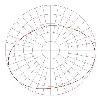 | ||||||||||||||||||
| Azimuth | Ratio | Azimuth | Ratio | Azimuth | Ratio | Azimuth | Ratio | ||||||||||||
| 0 | 0.543 | 10 | 0.551 | 20 | 0.570 | 30 | 0.603 | ||||||||||||
| 40 | 0.651 | 50 | 0.707 | 60 | 0.781 | 70 | 0.864 | ||||||||||||
| 80 | 0.932 | 90 | 0.974 | 100 | 0.991 | 110 | 0.985 | ||||||||||||
| 120 | 0.962 | 130 | 0.929 | 140 | 0.893 | 150 | 0.862 | ||||||||||||
| 160 | 0.842 | 170 | 0.837 | 180 | 0.845 | 190 | 0.868 | ||||||||||||
| 200 | 0.901 | 210 | 0.936 | 220 | 0.972 | 230 | 0.994 | ||||||||||||
| 240 | 1.000 | 250 | 0.979 | 260 | 0.935 | 270 | 0.864 | ||||||||||||
| 280 | 0.779 | 290 | 0.702 | 300 | 0.645 | 310 | 0.593 | ||||||||||||
| 320 | 0.561 | 330 | 0.545 | 340 | 0.539 | 350 | 0.540 | ||||||||||||
Structure Registration Number 1217182 Structure Type: TOWER Registered To: Crown Communications LLC Structure Address: 4647 Clearwell Rd Conway, AR County Name: Faulkner County ASR Issued: 05/06/2016 Date Built: 09/30/2000 Site Elevation: 150.9 m (495 ft.) Structure Height: 91.4 m (300 ft.) Height Overall: 96 m (315 ft.) Overall Height AMSL: 246.9 m (810 ft.) FAA Determination: 07/24/2000 FAA Study #: 00-ASW-2401-OE FAA Circular #: 70/7460-1J Paint & Light FAA Chapters: 4, 8, 13 Removed expiration date from determination. Scenario 1./jjs/case#635066 35-06-34.3 N 92-30-27.5 W (NAD 83) 35-06-34.0 N 92-30-26.9 W (Converted to NAD 27) |
P.o. Box 789 Highway 64 West Wynne, AR 72396 Phone: 870-238-8141 Corporation | Title: Managing Member Date: 02/07/2023 Application Certifier EAST ARKANSAS BROADCASTERS, INC. East Arkansas Broadcasters, Inc. P.o. Box 789 Highway 64 West Wynne, AR 72396 Applicant CHARLES M. ANDERSON Anderson Associates 5900 Lake Cyrus Drive Hoover, AL 35244 BROADCAST ENGINEERING CONSULTANT | |||||||||||||||||