
FCCInfo.com
A Service of Cavell, Mertz & Associates, Inc.
(855) FCC-INFO
|
|
|
|
|
||||||||||||||||
|
|
W277AO Channel: 277D 103.3 MHz Dayton, Ohio Service: FX - A translator or application for a translator. Facility ID: 138923 Fac. Service: FX Programming Delivery Method: Unspecified Status: Construction Permit Application Accepted: 02/27/2023 Application Granted: 03/21/2023 File Number: -0000211451 W277AO CP Expires: 03/21/2026 Application Type: Minor Modification FCC Website Links: LMS Facility Details This Application Other W277AO Applications Other W277AO Applications in CDBS Including Superseded Applications Mailing Address Correspondence for W277AO Correspondence related to application -0000211451 Service Contour - Open Street Map or USGS Map (60 dBu) Service Contour - KML / Google Earth (60 dBu) Facility Type: FM STATION Class: D, A Noncommercial educational operating with no more than 10W Site Location: 39-49-32.3 N 84-08-59.2 W (NAD 83) Site Location: 39-49-32.1 N 84-08-59.4 W (Converted to NAD 27) Effective Radiated Power: 0.25 kW Antenna Center HAAT: 0 m Antenna Center AMSL: 325.9 m (1069 ft.) Antenna Center HAG: 70 m (230 ft.) Site Elevation: 255.9 m. (840 ft.) Height Overall*: 111.6 m (366 ft.) (* As Filed In This Application, may differ from ASR Data, Below.) Directional Antenna Antenna Make/Model: Kathrein Scala 2CA2-FM/CP Antenna ID: 0 Polarization: H
| ||||||||||||||||||
| Antenna Data for Antenna Id: 0 W277AO FX File: -0000211451 Kathrein Scala - 2CA2-FM/CP Service: FX | 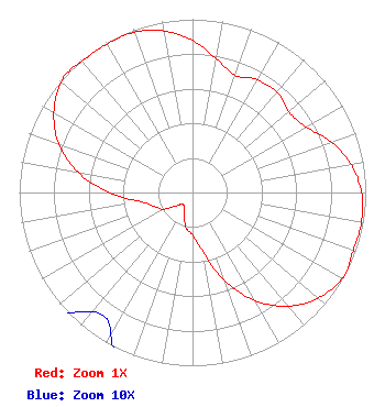 | ||||||||||||||||||
| Azimuth | Ratio | Azimuth | Ratio | Azimuth | Ratio | Azimuth | Ratio | ||||||||||||
| 0 | 0.878 | 10 | 0.784 | 20 | 0.721 | 30 | 0.751 | ||||||||||||
| 40 | 0.757 | 50 | 0.725 | 60 | 0.757 | 70 | 0.852 | ||||||||||||
| 80 | 0.929 | 90 | 0.976 | 100 | 0.990 | 110 | 0.987 | ||||||||||||
| 117 | 1.000 | 120 | 0.997 | 130 | 0.947 | 140 | 0.857 | ||||||||||||
| 150 | 0.720 | 160 | 0.541 | 170 | 0.343 | 180 | 0.247 | ||||||||||||
| 190 | 0.208 | 200 | 0.138 | 210 | 0.094 | 220 | 0.090 | ||||||||||||
| 230 | 0.116 | 240 | 0.193 | 250 | 0.236 | 260 | 0.303 | ||||||||||||
| 270 | 0.481 | 280 | 0.670 | 290 | 0.820 | 300 | 0.924 | ||||||||||||
| 310 | 0.989 | 316 | 1.000 | 320 | 0.990 | 330 | 0.989 | ||||||||||||
| 340 | 0.984 | 350 | 0.947 | ||||||||||||||||
Structure Registration Number 1011072 Structure Type: TOWER Registered To: City of Huber Heights, OH Structure Address: 0.58 Km (0.36 Mi) Nw Of Needmore Road And Old Troy Pike (hooks Corner) Huber Heights, OH County Name: Montgomery County ASR Issued: 10/03/2006 Date Built: 06/01/1975 Site Elevation: 255.9 m (840 ft.) Structure Height: 109.8 m (360 ft.) Height Overall: 111.6 m (366 ft.) Overall Height AMSL: 367.5 m (1206 ft.) FAA Determination: 02/27/2003 FAA Study #: 2002-AGL-7190-OE Paint & Light FAA Chapters: 1, 3, 12, 21 OM&L TO REMAIN PAINT RED LIGHTS 39-49-32.3 N 84-08-59.2 W (NAD 83) 39-49-32.1 N 84-08-59.4 W (Converted to NAD 27) |
Beavercreek, OH 45432 Phone: 937-367-7383 Individual | Title: Licensee Date: 02/27/2023 Application Certifier BRADLEE J BEER 4414 Castle Gate Drive Beavercreek, OH 45432 Applicant BRADLEE J. BEER Beer Bcdayton Broadcasting Llc 4414 Castle Gate Drive Beavercreek, OH 45432 BRADLEE J BEER Beer Bcdayton Broadcasting Llc 4414 Castle Gate Drive Beavercreek, OH 45432 SELF | |||||||||||||||||