
FCCInfo.com
A Service of Cavell, Mertz & Associates, Inc.
(855) FCC-INFO
|
|
|
|
|
||||||||||||||||
|
|
W283DE Channel: 283D 104.5 MHz Durham, North Carolina Service: FX - A translator or application for a translator. Facility ID: 200547 Fac. Service: FX Programming Delivery Method: Unspecified Status: License Application Accepted: 04/05/2023 Application Granted: 04/13/2023 File Number: -0000213555 License Expires: 12/01/2027 Application Type: License To Cover FCC Website Links: LMS Facility Details This Application Other W283DE Applications Other W283DE Applications in CDBS Including Superseded Applications Mailing Address Correspondence for W283DE Correspondence related to application -0000213555 Service Contour - Open Street Map or USGS Map (60 dBu) Service Contour - KML / Google Earth (60 dBu) Facility Type: FM STATION Class: D, A Noncommercial educational operating with no more than 10W Site Location: 35-51-59.0 N 79-10-00.5 W (NAD 83) Site Location: 35-51-58.5 N 79-10-01.5 W (Converted to NAD 27) Effective Radiated Power: 0.18 kW Antenna Center HAAT: 0 m Antenna Center AMSL: 362.2 m (1188 ft.) Antenna Center HAG: 136 m (446 ft.) Site Elevation: 226.2 m. (742 ft.) Height Overall*: 394.4 m (1294 ft.) (* As Filed In This Application, may differ from ASR Data, Below.) Directional Antenna Antenna Make/Model: Kathrein-Scala CA2-FM/CP Array Antenna ID: 1010428 Polarization: H
| ||||||||||||||||||
| Antenna Data for Antenna Id: 1010428 W283DE FX File: -0000213555 Kathrein-Scala - CA2-FM/CP Array Service: FX | 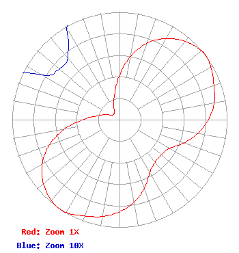 | ||||||||||||||||||
| Azimuth | Ratio | Azimuth | Ratio | Azimuth | Ratio | Azimuth | Ratio | ||||||||||||
| 0 | 0.410 | 10 | 0.598 | 20 | 0.757 | 30 | 0.870 | ||||||||||||
| 40 | 0.950 | 50 | 0.995 | 53 | 1.000 | 60 | 0.980 | ||||||||||||
| 70 | 0.934 | 80 | 0.894 | 90 | 0.828 | 100 | 0.740 | ||||||||||||
| 110 | 0.635 | 120 | 0.536 | 130 | 0.508 | 140 | 0.515 | ||||||||||||
| 150 | 0.566 | 160 | 0.679 | 170 | 0.778 | 180 | 0.857 | ||||||||||||
| 190 | 0.913 | 200 | 0.951 | 210 | 0.994 | 213 | 1.000 | ||||||||||||
| 220 | 0.982 | 230 | 0.923 | 240 | 0.829 | 250 | 0.699 | ||||||||||||
| 260 | 0.526 | 270 | 0.341 | 280 | 0.206 | 290 | 0.139 | ||||||||||||
| 300 | 0.083 | 310 | 0.073 | 320 | 0.075 | 330 | 0.098 | ||||||||||||
| 340 | 0.165 | 350 | 0.250 | ||||||||||||||||
Structure Registration Number 1014574 Structure Type: GTOWER Registered To: UNIVERSITY OF NORTH CAROLINA Structure Address: 4401 Jones Ferry Road Chapel Hill, NC County Name: Chatham County ASR Issued: 11/21/2023 Date Built: 02/19/2024 Site Elevation: 226.2 m (742 ft.) Structure Height: 360.6 m (1183 ft.) Height Overall: 394.4 m (1294 ft.) Overall Height AMSL: 620.6 m (2036 ft.) FAA Determination: 04/25/2023 FAA Study #: 2022-ASO-42340-OE FAA Circular #: 70/7460-1M Paint & Light FAA Chapters: 4, 9, 15 PRIOR STUDY 2010-ASO-1608-OE 35-51-59.0 N 79-10-00.5 W (NAD 83) 35-51-58.5 N 79-10-01.5 W (Converted to NAD 27) |
2619 Western Blvd Raleigh, NC 27606 Phone: 919-821-8933 Limited Liability Company | Title: Vice President Date: 04/05/2023 Application Certifier WDNC-AM, LLC Wdnc-am, Llc 2619 Western Blvd Raleigh, NC 27606 Applicant Louis R duTreil, Jr Dutreil Lundin & Rackley Inc 5212 Station Way Sarasota, FL 34233 Technical Consultant David A. O'Connor Wilkinson Barker Knauer, Llp 1800 M Street Nw Suite 800n Washington, DC 20036 FCC Counsel | |||||||||||||||||