
FCCInfo.com
A Service of Cavell, Mertz & Associates, Inc.
(855) FCC-INFO
|
|
W297BV from 01/16/2014 |
|
|
||||||||||||||||
|
|
W297BV Channel: 297D 107.3 MHz Louisville, Kentucky Service: FX - A translator or application for a translator. Facility ID: 142519 Fac. Service: FX Programming Delivery Method: Unspecified Status: License Application Accepted: 05/11/2023 Application Granted: 06/08/2023 File Number: -0000214710 License Expires: 08/01/2028 Application Type: License To Cover FCC Website Links: LMS Facility Details This Application Other W297BV Applications Other W297BV Applications in CDBS Including Superseded Applications Mailing Address Correspondence for W297BV Correspondence related to application -0000214710 Service Contour - Open Street Map or USGS Map (60 dBu) Service Contour - KML / Google Earth (60 dBu) Facility Type: FM STATION Class: D, A Noncommercial educational operating with no more than 10W Site Location: 38-15-57.5 N 85-42-49.7 W (NAD 83) Site Location: 38-15-57.2 N 85-42-49.8 W (Converted to NAD 27) Effective Radiated Power: 0.25 kW Transmitter Output Power: 0.506 kW Antenna Center HAAT: 0 m Antenna Center AMSL: 228.6 m (750 ft.) Antenna Center HAG: 97.5 m (320 ft.) Site Elevation: 131.1 m. (430 ft.) Height Overall*: 119.5 m (392 ft.) (* As Filed In This Application, may differ from ASR Data, Below.) Directional Antenna Antenna Make/Model: Propagation System Inc FML-2A-70WS-DA Antenna ID: 126391 Polarization: H
| ||||||||||||||||||
| Antenna Data for Antenna Id: 126391 W297BV FX File: -0000214710 Propagation System Inc - FML-2A-70WS-DA Service: FX | 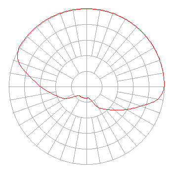 | ||||||||||||||||||
| Azimuth | Ratio | Azimuth | Ratio | Azimuth | Ratio | Azimuth | Ratio | ||||||||||||
| 0 | 1.000 | 10 | 1.000 | 20 | 1.000 | 30 | 1.000 | ||||||||||||
| 40 | 1.000 | 50 | 1.000 | 60 | 1.000 | 70 | 1.000 | ||||||||||||
| 80 | 1.000 | 90 | 1.000 | 100 | 0.930 | 110 | 0.740 | ||||||||||||
| 120 | 0.590 | 130 | 0.470 | 140 | 0.380 | 150 | 0.310 | ||||||||||||
| 160 | 0.200 | 170 | 0.150 | 180 | 0.150 | 190 | 0.150 | ||||||||||||
| 200 | 0.150 | 210 | 0.150 | 220 | 0.150 | 230 | 0.200 | ||||||||||||
| 240 | 0.310 | 250 | 0.380 | 260 | 0.470 | 270 | 0.590 | ||||||||||||
| 280 | 0.740 | 290 | 0.930 | 300 | 1.000 | 310 | 1.000 | ||||||||||||
| 320 | 1.000 | 330 | 1.000 | 340 | 1.000 | 350 | 1.000 | ||||||||||||
Structure Registration Number 1255569 Structure Type: TOWER Registered To: WORD BROADCASTING NETWORK, INC. Structure Address: River Road At Edith Road Louisville, KY County Name: Jefferson County ASR Issued: 06/02/2022 Date Built: 07/12/2008 Site Elevation: 131.1 m (430 ft.) Structure Height: 118.6 m (389 ft.) Height Overall: 119.5 m (392 ft.) Overall Height AMSL: 250.6 m (822 ft.) FAA Determination: 08/18/2006 FAA Study #: 2006-ASO-2418-OE FAA Circular #: 70/7460-1K Paint & Light FAA Chapters: 3, 4, 5, 12 Removed expiration date from determination. Scenario 1./jjs/case#635066 38-15-57.5 N 85-42-49.7 W (NAD 83) 38-15-57.2 N 85-42-49.8 W (Converted to NAD 27) |
6900 Billtown Road Louisville, KY 40299 Phone: 502-964-2121 Not-for-Profit | Title: President Date: 05/11/2023 Application Certifier SALEM COMMUNICATIONS HOLDING CORPORATION Word Broadcasting Network, Inc. 6900 Billtown Road Louisville, KY 40299 Applicant CLARENCE M BEVERAGE Communications Technologies, Inc. 23 Binsted Drive Medford, NJ 08055 Broadcast Engineering Consultant ANTHONY T LEPORE Radiotvlaw Associates, Llc 4101 Albemarle Street Nw #324 Washington, DC 20016 | |||||||||||||||||