
FCCInfo.com
A Service of Cavell, Mertz & Associates, Inc.
(855) FCC-INFO
|
|
|
|  |
|
|||||||||||||||
|
|
WDDE Channel: 216B1 91.1 MHz Dover, Delaware Service: FM - A full-service FM station or application. Facility ID: 175387 Fac. Service: FM Status: Construction Permit Application Accepted: 08/02/2023 Application Granted: 09/20/2023 File Number: -0000218845 WDDE CP Expires: 06/09/2025 Application Type: Minor Modification FCC Website Links: LMS Facility Details This Application Other WDDE Applications Other WDDE Applications in CDBS Including Superseded Applications Mailing Address Correspondence for WDDE Correspondence related to application -0000218845 Service Contour - Open Street Map or USGS Map (60 dBu) Service Contour - KML / Google Earth (60 dBu) Public Inspection Files Facility Type: NON-COMMERCIAL EDUC. FM Class: B1, A Zone I or I-A station; with 6kW-25kW ERP and a class contour distance 28km-39km Site Location: 38-59-01.0 N 75-33-13.0 W (NAD 83) Site Location: 38-59-00.6 N 75-33-14.3 W (Converted to NAD 27) Effective Radiated Power: 9 kW Antenna Center HAAT: 94 m (308 ft.) Antenna Center AMSL: 106 m (348 ft.) Antenna Center HAG: 92 m (302 ft.) Site Elevation: 14.9 m. (49 ft.) Height Overall*: 143.3 m (470 ft.) (* As Filed In This Application, may differ from ASR Data, Below.) Directional Antenna Antenna Make/Model: None Antenna ID: 1006063 Polarization: | ||||||||||||||||||
| Antenna Data for Antenna Id: 1006063 WDDE FM File: -0000218845 None - Service: FM | 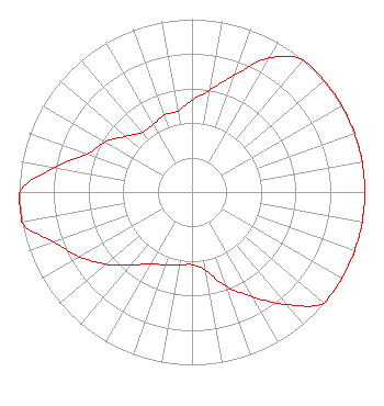 | ||||||||||||||||||
| Azimuth | Ratio | Azimuth | Ratio | Azimuth | Ratio | Azimuth | Ratio | ||||||||||||
| 0 | 0.530 | 10 | 0.600 | 20 | 0.720 | 30 | 0.897 | ||||||||||||
| 40 | 1.000 | 50 | 1.000 | 60 | 1.000 | 70 | 1.000 | ||||||||||||
| 80 | 1.000 | 90 | 1.000 | 100 | 1.000 | 110 | 1.000 | ||||||||||||
| 120 | 1.000 | 130 | 1.000 | 140 | 0.850 | 150 | 0.700 | ||||||||||||
| 160 | 0.580 | 170 | 0.460 | 180 | 0.420 | 190 | 0.430 | ||||||||||||
| 200 | 0.450 | 210 | 0.480 | 220 | 0.550 | 230 | 0.650 | ||||||||||||
| 240 | 0.750 | 250 | 0.850 | 260 | 1.000 | 270 | 1.000 | ||||||||||||
| 280 | 0.810 | 290 | 0.647 | 300 | 0.580 | 310 | 0.500 | ||||||||||||
| 320 | 0.450 | 330 | 0.450 | 340 | 0.475 | 350 | 0.475 | ||||||||||||
Structure Registration Number 1060162 Structure Type: Registered To: Delaware Division of Communications Structure Address: Lake Forest H.s. 5423 Killen's Pond Rd Felton, DE County Name: Kent County ASR Issued: 08/09/2023 Date Built: 08/08/1997 Site Elevation: 14.9 m (49 ft.) Structure Height: 137.2 m (450 ft.) Height Overall: 143.3 m (470 ft.) Overall Height AMSL: 158.2 m (519 ft.) FAA Determination: 02/06/1997 FAA Study #: 96-AEA-2506-OE FAA Circular #: 70/7460-1J Paint & Light FAA Chapters: 4, 8, 13 38-59-01.0 N 75-33-13.0 W (NAD 83) 38-59-00.6 N 75-33-14.3 W (Converted to NAD 27) |
Dover, DE 19903 Phone: 302-857-7096 Not-for-Profit | Title: President Date: 08/02/2023 Application Certifier Delaware Public Media Corporation Dover, DE 19903 Applicant Howard Liberman Wilkinson Barker Knauer, Llp 1800 M Street Nw Suite 800n Washington, DC 20036 | |||||||||||||||||