
FCCInfo.com
A Service of Cavell, Mertz & Associates, Inc.
(855) FCC-INFO
|
|
K236BM from 09/23/2004 K236BM from 04/26/2000 |
|
|
||||||||||||||||
|
|
K236BM Channel: 236D 95.1 MHz Las Vegas, Nevada Service: FX - A translator or application for a translator. Facility ID: 93213 Fac. Service: FX Programming Delivery Method: Unspecified Status: Construction Permit Application Accepted: 07/28/2023 Application Granted: 08/16/2023 File Number: -0000218617 K236BM CP Expires: 09/14/2025 Application Type: Minor Modification FCC Website Links: LMS Facility Details This Application Other K236BM Applications Other K236BM Applications in CDBS Including Superseded Applications Mailing Address Correspondence for K236BM Correspondence related to application -0000218617 Service Contour - Open Street Map or USGS Map (60 dBu) Service Contour - KML / Google Earth (60 dBu) Facility Type: NON-COMMERCIAL EDUC. FM Class: D, A Noncommercial educational operating with no more than 10W Site Location: 36-00-34.4 N 115-00-23.0 W (NAD 83) Site Location: 36-00-34.5 N 115-00-20.0 W (Converted to NAD 27) Effective Radiated Power: 0 kW Horiz. ; 0.25 kW Vert. Antenna Center HAAT: 0 m Antenna Center AMSL: 991.2 m Horiz.; 1021.2 m Vert. (3252 ft. Horiz. / 3350 ft. Vert.) Antenna Center HAG: 0 m Horiz.; 30 m Vert. Site Elevation: 991.2 m. (3252 ft.) Height Overall*: 77.1 m (253 ft.) (* As Filed In This Application, may differ from ASR Data, Below.) Directional Antenna Antenna Make/Model: Scala CL-FMV Antenna ID: 134538 Polarization: H
| ||||||||||||||||||
| Antenna Data for Antenna Id: 134538 K236BM FX File: -0000218617 Scala - CL-FMV Service: FX | 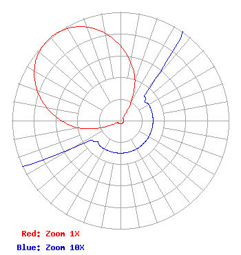 | ||||||||||||||||||
| Azimuth | Ratio | Azimuth | Ratio | Azimuth | Ratio | Azimuth | Ratio | ||||||||||||
| 0 | 0.690 | 10 | 0.544 | 20 | 0.390 | 30 | 0.190 | ||||||||||||
| 40 | 0.050 | 50 | 0.030 | 60 | 0.030 | 70 | 0.030 | ||||||||||||
| 80 | 0.030 | 90 | 0.030 | 100 | 0.030 | 110 | 0.030 | ||||||||||||
| 120 | 0.030 | 130 | 0.030 | 140 | 0.030 | 150 | 0.030 | ||||||||||||
| 160 | 0.030 | 170 | 0.030 | 180 | 0.030 | 190 | 0.030 | ||||||||||||
| 200 | 0.030 | 210 | 0.030 | 220 | 0.030 | 230 | 0.030 | ||||||||||||
| 240 | 0.050 | 250 | 0.190 | 260 | 0.390 | 270 | 0.544 | ||||||||||||
| 280 | 0.690 | 290 | 0.818 | 300 | 0.917 | 310 | 0.980 | ||||||||||||
| 320 | 1.000 | 330 | 0.980 | 340 | 0.917 | 350 | 0.818 | ||||||||||||
Structure Registration Number 1304131 Structure Type: LTOWER Registered To: American Towers LLC Structure Address: Black Mountain Road .7 Miles West Of I-515 (280506 Black Mt Twr 12) Henderson, NV County Name: Clark County ASR Issued: 04/23/2018 Date Built: 11/21/2017 Site Elevation: 991.2 m (3252 ft.) Structure Height: 61.3 m (201 ft.) Height Overall: 77.1 m (253 ft.) Overall Height AMSL: 1068.3 m (3505 ft.) FAA Determination: 04/20/2018 FAA Study #: 2017-AWP-12572-OE FAA Circular #: 70/7460-1L Paint & Light FAA Chapters: 4, 6, 12 PRIOR STUDY 2017-AWP-6831-OE 36-00-34.4 N 115-00-23.0 W (NAD 83) 36-00-34.5 N 115-00-20.0 W (Converted to NAD 27) |
5700 West Oaks Blvd Rocklin, CA 95765 Phone: 916-251-1600 Not-for-Profit | Title: Acting Chief Financial Officer Date: 07/28/2023 Application Certifier EDUCATIONAL MEDIA FOUNDATION Educational Media Foundation 5700 West Oaks Blvd Rocklin, CA 95765 Applicant MARY O'CONNOR Wilkinson Barker Knauer, Llp 1800 M Street, N. W. Suite 800n Washington, DC 20036 Legal Counsel James L Travis Educational Media Foundation 5700 West Oaks Blvd. Rocklin, CA 95765 FCC COMPLIANCE ENGINEER | |||||||||||||||||