
FCCInfo.com
A Service of Cavell, Mertz & Associates, Inc.
(855) FCC-INFO
|
|
|
|
|
||||||||||||||||
|
|
K209CJ Channel: 209D 89.7 MHz Tooele, Utah Service: FX - A translator or application for a translator. Facility ID: 84118 Fac. Service: FX Programming Delivery Method: Unspecified Status: License Application Accepted: 08/02/2023 Application Granted: 08/11/2023 File Number: -0000218854 License Expires: 10/01/2029 Application Type: License To Cover FCC Website Links: LMS Facility Details This Application Other K209CJ Applications Other K209CJ Applications in CDBS Including Superseded Applications Mailing Address Correspondence for K209CJ Correspondence related to application -0000218854 Service Contour - Open Street Map or USGS Map (60 dBu) Service Contour - KML / Google Earth (60 dBu) Facility Type: NON-COMMERCIAL EDUC. FM Class: D, A Noncommercial educational operating with no more than 10W Site Location: 40-48-29.0 N 111-53-25.0 W (NAD 83) Site Location: 40-48-29.2 N 111-53-22.2 W (Converted to NAD 27) Effective Radiated Power: 0.25 kW Transmitter Output Power: 0.024 kW Antenna Center HAAT: 0 m Antenna Center AMSL: 1848.8 m (6066 ft.) Antenna Center HAG: 38 m (125 ft.) Site Elevation: 1810.8 m. (5941 ft.) Height Overall*: 40.2 m (132 ft.) (* As Filed In This Application, may differ from ASR Data, Below.) Directional Antenna Antenna Make/Model: Scala CA2-CP Antenna ID: 121020 Polarization: H
| ||||||||||||||||||
| Antenna Data for Antenna Id: 121020 K209CJ FX File: -0000218854 Scala - CA2-CP Service: FX | 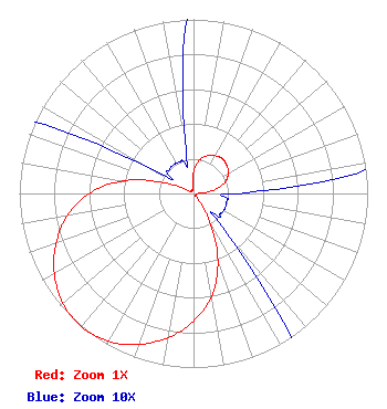 | ||||||||||||||||||
| Azimuth | Ratio | Azimuth | Ratio | Azimuth | Ratio | Azimuth | Ratio | ||||||||||||
| 0 | 0.125 | 10 | 0.195 | 20 | 0.230 | 30 | 0.250 | ||||||||||||
| 40 | 0.260 | 50 | 0.250 | 60 | 0.230 | 70 | 0.195 | ||||||||||||
| 80 | 0.125 | 90 | 0.025 | 100 | 0.020 | 110 | 0.020 | ||||||||||||
| 120 | 0.020 | 130 | 0.020 | 140 | 0.030 | 150 | 0.185 | ||||||||||||
| 160 | 0.410 | 170 | 0.600 | 180 | 0.735 | 190 | 0.840 | ||||||||||||
| 200 | 0.923 | 210 | 0.980 | 220 | 1.000 | 230 | 0.980 | ||||||||||||
| 240 | 0.923 | 250 | 0.840 | 260 | 0.735 | 270 | 0.600 | ||||||||||||
| 280 | 0.410 | 290 | 0.185 | 300 | 0.030 | 310 | 0.020 | ||||||||||||
| 320 | 0.020 | 330 | 0.020 | 340 | 0.020 | 350 | 0.025 | ||||||||||||
Structure Registration Number 1044646 Structure Type: TOWER Registered To: ALPHA COMMUNICATIONS SITES DBA = UTAH COMMUNICATIONS INC Structure Address: E Of Bonneville Dr Between Jones And Hall Canyons Salt Lake City, UT County Name: Salt Lake County ASR Issued: 04/20/1998 Date Built: 01/01/1994 Site Elevation: 1810.8 m (5941 ft.) Structure Height: 37.2 m (122 ft.) Height Overall: 40.2 m (132 ft.) Overall Height AMSL: 1851 m (6073 ft.) FAA Determination: 09/29/1995 FAA Study #: 94-ANM-0377-OE Paint & Light FAA Chapters: NONE Removed expiration date from determination. Scenario 1./jjs/case#635066 40-48-29.0 N 111-53-25.0 W (NAD 83) 40-48-29.2 N 111-53-22.2 W (Converted to NAD 27) |
5700 West Oaks Blvd Rocklin, CA 95765 Phone: 916-251-1600 Not-for-Profit | Title: Acting Chief Financial Officer Date: 08/02/2023 Application Certifier EDUCATIONAL MEDIA FOUNDATION Educational Media Foundation 5700 West Oaks Blvd Rocklin, CA 95765 Applicant Mary N. O'Connor, ESQ Wilkinson Barker Knauer, Llp 1800 M. Street, N.w. Suite 800n Washington, DC 20036 Legal Representative James L Travis Educational Media Foundation 5700 West Oaks Blvd. Rocklin, CA 95765 FCC COMPLIANCE ENGINEER | |||||||||||||||||