
FCCInfo.com
A Service of Cavell, Mertz & Associates, Inc.
(855) FCC-INFO
|
|
|
|  |
|
|||||||||||||||
|
|
WJFR Channel: 204C3 88.7 MHz Jacksonville, Florida Service: FM - A full-service FM station or application. Facility ID: 20864 Fac. Service: FM Status: License Application Accepted: 08/07/2023 Application Granted: 08/23/2023 File Number: -0000219008 License Expires: 02/01/2028 Application Type: License To Cover FCC Website Links: LMS Facility Details This Application Other WJFR Applications Other WJFR Applications in CDBS Including Superseded Applications Mailing Address Correspondence for WJFR Correspondence related to application -0000219008 Service Contour - Open Street Map or USGS Map (60 dBu) Service Contour - KML / Google Earth (60 dBu) Public Inspection Files Facility Type: NON-COMMERCIAL EDUC. FM Class: C3, A Zone II station; with 6kW-25kW ERP and a class contour distance 28km-39km Site Location: 30-16-36.0 N 81-33-57.0 W (NAD 83) Site Location: 30-16-35.1 N 81-33-57.7 W (Converted to NAD 27) Effective Radiated Power: 12 kW Transmitter Output Power: 9.44 kW Antenna Center HAAT: 110 m (361 ft.) Antenna Center AMSL: 124 m (407 ft.) Antenna Center HAG: 116 m (381 ft.) Site Elevation: 7.9 m. (26 ft.) Height Overall*: 305.3 m (1002 ft.) (* As Filed In This Application, may differ from ASR Data, Below.) Directional Antenna Antenna Make/Model: Electronics Research Inc. LP-4E-DA, 4 sections Antenna ID: 0 Polarization: H | ||||||||||||||||||
| Antenna Data for Antenna Id: 0 WJFR FM File: -0000219008 Electronics Research Inc. - LP-4E-DA, 4 sections Service: FM | 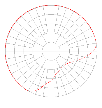 | ||||||||||||||||||
| Azimuth | Ratio | Azimuth | Ratio | Azimuth | Ratio | Azimuth | Ratio | ||||||||||||
| 0 | 1.000 | 10 | 1.000 | 20 | 1.000 | 30 | 1.000 | ||||||||||||
| 40 | 1.000 | 50 | 1.000 | 60 | 1.000 | 70 | 1.000 | ||||||||||||
| 80 | 1.000 | 90 | 0.922 | 100 | 0.749 | 110 | 0.602 | ||||||||||||
| 120 | 0.492 | 130 | 0.439 | 140 | 0.422 | 150 | 0.437 | ||||||||||||
| 160 | 0.468 | 170 | 0.535 | 180 | 0.644 | 190 | 0.741 | ||||||||||||
| 200 | 0.904 | 210 | 1.000 | 220 | 1.000 | 230 | 1.000 | ||||||||||||
| 240 | 1.000 | 250 | 1.000 | 260 | 1.000 | 270 | 1.000 | ||||||||||||
| 280 | 1.000 | 290 | 1.000 | 300 | 1.000 | 310 | 1.000 | ||||||||||||
| 320 | 1.000 | 330 | 1.000 | 340 | 1.000 | 350 | 1.000 | ||||||||||||
Structure Registration Number 1016457 Structure Type: GTOWER Registered To: American Towers LLC Structure Address: 9050 Hogan Road (#207748) Jacksonville, FL County Name: Duval County ASR Issued: 10/26/2022 Date Built: 07/01/1988 Site Elevation: 7.9 m (26 ft.) Structure Height: 289.8 m (951 ft.) Height Overall: 305.3 m (1002 ft.) Overall Height AMSL: 313.2 m (1028 ft.) FAA Determination: 11/16/2021 FAA Study #: 2021-ASO-25036-OE FAA Circular #: 70/7460-1M Paint & Light FAA Chapters: 4, 9, 15 PRIOR STUDY 1988-ASO-1533-OE 30-16-36.8 N 81-33-57.0 W (NAD 83) 30-16-35.9 N 81-33-57.7 W (Converted to NAD 27) |
301 Maple Street, Suite 2 (pob 286) Shenandoah, IA 51601 Phone: 712-246-5151 Not-for-Profit | Title: President Date: 08/07/2023 Application Certifier FAMILY STATIONS, INC. Family Stations, Inc. 301 Maple Street, Po Box 286 Shenandoah, IA 51601 Applicant Robert Branch Ctm 440 Astillero Street Las Vegas, NV 89138 Technical Consultant KATHLEEN VICTORY Fletcher, Heald & Hildreth, P.l.c. 13oo North 17th Street, 11th Floor Arlington, VA 22209 ESQ. | |||||||||||||||||