
FCCInfo.com
A Service of Cavell, Mertz & Associates, Inc.
(855) FCC-INFO
|
|
K281BL from 06/16/1997 |
|
|
||||||||||||||||
|
|
K281BL Channel: 281D 104.1 MHz Coyote, California Service: FX - A translator or application for a translator. Facility ID: 87357 Fac. Service: FX Programming Delivery Method: Unspecified Status: Construction Permit Application Accepted: 08/07/2023 Application Granted: 08/29/2023 File Number: -0000217158 K281BL CP Expires: 08/29/2026 Application Type: Minor Amendment FCC Website Links: LMS Facility Details This Application Other K281BL Applications Other K281BL Applications in CDBS Including Superseded Applications Mailing Address Correspondence for K281BL Correspondence related to application -0000217158 Service Contour - Open Street Map or USGS Map (60 dBu) Service Contour - KML / Google Earth (60 dBu) Facility Type: FM STATION Class: D, A Noncommercial educational operating with no more than 10W Site Location: 37-19-21.8 N 121-45-18.7 W (NAD 83) Site Location: 37-19-22.0 N 121-45-14.9 W (Converted to NAD 27) Effective Radiated Power: 0 kW Horiz. ; 0.25 kW Vert. Antenna Center HAAT: -24.3 m Horiz.; 0 m Vert. Antenna Center AMSL: 0 m Horiz.; 308 m Vert. Antenna Center HAG: 0 m Horiz.; 14 m Vert. Site Elevation: 294 m. (965 ft.) Height Overall*: 59.4 m (195 ft.) (* As Filed In This Application, may differ from ASR Data, Below.) Directional Antenna Antenna Make/Model: Scala CLFM-V Antenna ID: 16151 Polarization: H
| ||||||||||||||||||
| Antenna Data for Antenna Id: 16151 K281BL FX File: -0000217158 Scala - CLFM-V Service: FX | 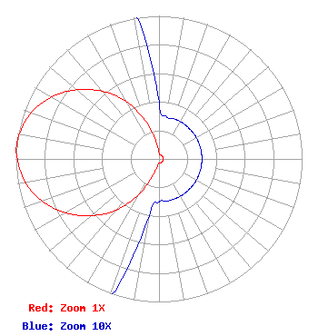 | ||||||||||||||||||
| Azimuth | Ratio | Azimuth | Ratio | Azimuth | Ratio | Azimuth | Ratio | ||||||||||||
| 0 | 0.040 | 10 | 0.030 | 20 | 0.030 | 30 | 0.030 | ||||||||||||
| 40 | 0.030 | 50 | 0.030 | 60 | 0.030 | 70 | 0.030 | ||||||||||||
| 80 | 0.030 | 90 | 0.030 | 100 | 0.030 | 110 | 0.030 | ||||||||||||
| 120 | 0.030 | 130 | 0.030 | 140 | 0.030 | 150 | 0.030 | ||||||||||||
| 160 | 0.030 | 170 | 0.030 | 180 | 0.030 | 190 | 0.040 | ||||||||||||
| 200 | 0.120 | 210 | 0.290 | 220 | 0.467 | 230 | 0.617 | ||||||||||||
| 240 | 0.753 | 250 | 0.867 | 260 | 0.948 | 270 | 0.990 | ||||||||||||
| 275 | 1.000 | 280 | 0.990 | 290 | 0.948 | 300 | 0.867 | ||||||||||||
| 310 | 0.753 | 320 | 0.617 | 330 | 0.467 | 340 | 0.290 | ||||||||||||
| 350 | 0.120 | ||||||||||||||||||
Structure Registration Number 1049603 [ASR Heights Differ from K281BL Application] Structure Type: GTOWER Registered To: American Towers LLC Structure Address: 3903 Aborn Rd (#269318) San Jose, CA County Name: Santa Clara County ASR Issued: 05/28/2015 Date Built: 08/28/2001 Site Elevation: 293.5 m (963 ft.) Structure Height: 57.9 m (190 ft.) Height Overall: 59.4 m (195 ft.) Overall Height AMSL: 352.9 m (1158 ft.) FAA Determination: 05/07/2015 FAA Study #: 2015-AWP-4600-OE Paint & Light FAA Chapters: NONE PRIOR STUDY 2012-AWP-2454-OE 37-19-21.8 N 121-45-18.7 W (NAD 83) 37-19-22.0 N 121-45-14.9 W (Converted to NAD 27) |
5700 West Oaks Blvd. Rocklin, CA 95765 Phone: 916-251-1600 Not-for-Profit | Title: Acting Chief Financial Officer Date: 08/07/2023 Application Certifier EDUCATIONAL MEDIA FOUNDATION Educational Media Foundation 5700 West Oaks Blvd. Rocklin, CA 95765 Applicant David A Velasquez Educational Media Foundation 5700 West Oaks Blvd Rocklin, CA 95765 Signal Development MARY N. O'CONNOR Wilkinson Barker Knauer, Llp 1800 M Street Nw Suite 800n Washington, DC 20036 | |||||||||||||||||