
FCCInfo.com
A Service of Cavell, Mertz & Associates, Inc.
(855) FCC-INFO
|
|
W246DH from 05/13/2014 |
|
|
||||||||||||||||
|
|
W246DH Channel: 246D 97.1 MHz Knoxville, Tennessee Service: FX - A translator or application for a translator. Facility ID: 155941 Fac. Service: FX Programming Delivery Method: Unspecified Status: License Application Accepted: 08/14/2023 Application Granted: 08/24/2023 File Number: -0000219289 License Expires: 08/01/2028 Application Type: License To Cover FCC Website Links: LMS Facility Details This Application Other W246DH Applications Other W246DH Applications in CDBS Including Superseded Applications Mailing Address Correspondence for W246DH Correspondence related to application -0000219289 Service Contour - Open Street Map or USGS Map (60 dBu) Service Contour - KML / Google Earth (60 dBu) Facility Type: FM STATION Class: D, A Noncommercial educational operating with no more than 10W Site Location: 36-00-19.0 N 83-56-23.0 W (NAD 83) Site Location: 36-00-18.7 N 83-56-23.3 W (Converted to NAD 27) Effective Radiated Power: 0.1 kW Antenna Center HAAT: 0 m Antenna Center AMSL: 575 m (1886 ft.) Antenna Center HAG: 165 m (541 ft.) Site Elevation: 410 m. (1345 ft.) Height Overall*: 458.4 m (1504 ft.) (* As Filed In This Application, may differ from ASR Data, Below.) Directional Antenna Antenna Make/Model: Nicom BKG-77 Antenna ID: 1000899 Polarization: H
| ||||||||||||||||||
| Antenna Data for Antenna Id: 1000899 W246DH FX File: -0000219289 Nicom - BKG-77 Service: FX | 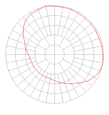 | ||||||||||||||||||
| Azimuth | Ratio | Azimuth | Ratio | Azimuth | Ratio | Azimuth | Ratio | ||||||||||||
| 0 | 0.984 | 10 | 0.976 | 20 | 0.976 | 30 | 0.966 | ||||||||||||
| 40 | 0.966 | 50 | 0.966 | 60 | 0.966 | 70 | 0.966 | ||||||||||||
| 80 | 0.976 | 90 | 0.984 | 100 | 1.000 | 110 | 0.982 | ||||||||||||
| 120 | 0.927 | 130 | 0.852 | 140 | 0.762 | 150 | 0.692 | ||||||||||||
| 160 | 0.627 | 170 | 0.581 | 180 | 0.536 | 190 | 0.504 | ||||||||||||
| 200 | 0.493 | 210 | 0.493 | 220 | 0.493 | 230 | 0.493 | ||||||||||||
| 240 | 0.493 | 250 | 0.493 | 260 | 0.507 | 270 | 0.536 | ||||||||||||
| 280 | 0.596 | 290 | 0.643 | 300 | 0.728 | 310 | 0.826 | ||||||||||||
| 320 | 0.908 | 330 | 0.947 | 340 | 0.966 | 350 | 1.000 | ||||||||||||
Structure Registration Number 1042631 Structure Type: TOWER Registered To: WBIR-TV, LLC Structure Address: 601 Memorial Parkway Knoxville, TN County Name: Knox County ASR Issued: 02/13/2019 Date Built: 01/01/1980 Site Elevation: 410 m (1345 ft.) Structure Height: 432.2 m (1418 ft.) Height Overall: 458.4 m (1504 ft.) Overall Height AMSL: 868.4 m (2849 ft.) Paint & Light FAA Chapters: A1, B, F, H 36-00-19.0 N 83-56-23.0 W (NAD 83) 36-00-18.7 N 83-56-23.3 W (Converted to NAD 27) |
10201 Thimble Fields Dr. Knoxville, TN 37922 Phone: 865-803-6633 Corporation | Title: Technical Consultant Date: 08/14/2023 Application Certifier OAK RIDGE FM, INC. Oak Ridge Fm, Inc. 10201 Thimble Fields Dr. Knoxville, TN 37922 Applicant AARON A ISHMAEL Ishmael Productions And Engineering 7212 Kingston Pike Suite 8 Knoxville, TN 37919 TECHNICAL CONSULTANT | |||||||||||||||||