
FCCInfo.com
A Service of Cavell, Mertz & Associates, Inc.
(855) FCC-INFO
|
|
|
|
|
||||||||||||||||
|
|
K204DX Channel: 204D 88.7 MHz San Antonio, Texas Service: FX - A translator or application for a translator. Facility ID: 91767 Fac. Service: FX Programming Delivery Method: Unspecified Status: Construction Permit Application Accepted: 08/25/2023 Application Pending: 08/25/2023 File Number: -0000219887 K204DX CP Expires: 00/00/0000 Application Type: Minor Modification FCC Website Links: LMS Facility Details This Application Other K204DX Applications Other K204DX Applications in CDBS Including Superseded Applications Mailing Address Correspondence for K204DX Correspondence related to application -0000219887 Service Contour - Open Street Map or USGS Map (60 dBu) Service Contour - KML / Google Earth (60 dBu) Facility Type: NON-COMMERCIAL EDUC. FM Class: D, A Noncommercial educational operating with no more than 10W Site Location: 29-26-29.9 N 98-30-22.8 W (NAD 83) Site Location: 29-26-29.1 N 98-30-21.7 W (Converted to NAD 27) Effective Radiated Power: 0.092 kW Antenna Center HAAT: 0 m Horiz.; 158.6 m Vert. Antenna Center AMSL: 356.2 m (1169 ft.) Antenna Center HAG: 149 m (489 ft.) Site Elevation: 207.2 m. (680 ft.) Height Overall*: 152 m (499 ft.) (* As Filed In This Application, may differ from ASR Data, Below.) Directional Antenna Antenna Make/Model: Propagation System Inc FML-1-DA Antenna ID: 1007221 Polarization:
| ||||||||||||||||||
| Antenna Data for Antenna Id: 1007221 K204DX FX File: -0000219887 Propagation System Inc - FML-1-DA Service: FX | 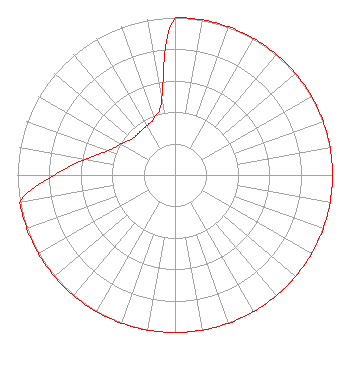 | ||||||||||||||||||
| Azimuth | Ratio | Azimuth | Ratio | Azimuth | Ratio | Azimuth | Ratio | ||||||||||||
| 0 | 1.000 | 10 | 1.000 | 20 | 1.000 | 30 | 1.000 | ||||||||||||
| 40 | 1.000 | 50 | 1.000 | 60 | 1.000 | 70 | 1.000 | ||||||||||||
| 80 | 1.000 | 90 | 1.000 | 100 | 1.000 | 110 | 1.000 | ||||||||||||
| 120 | 1.000 | 130 | 1.000 | 140 | 1.000 | 150 | 1.000 | ||||||||||||
| 160 | 1.000 | 170 | 1.000 | 180 | 1.000 | 190 | 1.000 | ||||||||||||
| 200 | 1.000 | 210 | 1.000 | 220 | 1.000 | 230 | 1.000 | ||||||||||||
| 240 | 1.000 | 250 | 1.000 | 260 | 1.000 | 270 | 0.766 | ||||||||||||
| 280 | 0.580 | 290 | 0.452 | 300 | 0.395 | 310 | 0.356 | ||||||||||||
| 320 | 0.353 | 330 | 0.360 | 340 | 0.387 | 350 | 0.493 | ||||||||||||
Structure Registration Number 1214327 Structure Type: GTOWER Registered To: American Towers LLC Structure Address: 1010 W. Laurel St. (atc Site # 282679) San Antonio, TX County Name: Bexar County ASR Issued: 05/24/2016 Date Built: 07/12/2001 Site Elevation: 207.2 m (680 ft.) Structure Height: 152 m (499 ft.) Height Overall: 152 m (499 ft.) Overall Height AMSL: 359.2 m (1178 ft.) FAA Determination: 03/16/2016 FAA Study #: 2016-ASW-2905-OE FAA Circular #: 70/7460-1L Paint & Light FAA Chapters: 4, 8, 12 PRIOR STUDY 2000-ASW-1251-OE 29-26-29.9 N 98-30-22.8 W (NAD 83) 29-26-29.1 N 98-30-21.7 W (Converted to NAD 27) |
4002 N. 3300 E. Twin Falls, ID 83303 Phone: 208-734-6633 Not-for-Profit | Title: President Date: 08/25/2023 Application Certifier CSN INTERNATIONAL Csn International 4002 N. 3300 E. Twin Falls, ID 83301 Applicant SCOTT SPENCER Csn International 4002 N. 3300 E. Twin Falls, ID 83303 TECHNICAL REPRESENTATIVE CARY TEPPER Tepper Law, Llc 4900 Auburn Ave, Suite 100 Bethesda, MD 20814 | |||||||||||||||||