
FCCInfo.com
A Service of Cavell, Mertz & Associates, Inc.
(855) FCC-INFO
|
|
|
|
|
||||||||||||||||
|
|
W290DJ Channel: 290D 105.9 MHz Maryville, Tennessee Service: FX - A translator or application for a translator. Facility ID: 200983 Fac. Service: FX Programming Delivery Method: Unspecified Status: License Application Accepted: 09/20/2023 Application Granted: 09/21/2023 File Number: -0000221166 License Expires: 08/01/2028 Application Type: License To Cover FCC Website Links: LMS Facility Details This Application Other W290DJ Applications Other W290DJ Applications in CDBS Including Superseded Applications Mailing Address Correspondence for W290DJ Correspondence related to application -0000221166 Service Contour - Open Street Map or USGS Map (60 dBu) Service Contour - KML / Google Earth (60 dBu) Facility Type: FM STATION Class: D, A Noncommercial educational operating with no more than 10W Site Location: 35-48-52.3 N 83-39-59.6 W (NAD 83) Site Location: 35-48-52.0 N 83-39-60.0 W (Converted to NAD 27) Effective Radiated Power: 0.05 kW Transmitter Output Power: 0.31 kW Antenna Center HAAT: 0 m Antenna Center AMSL: 847 m (2779 ft.) Antenna Center HAG: 50 m (164 ft.) Site Elevation: 797 m. (2615 ft.) Height Overall*: 60.3 m (198 ft.) (* As Filed In This Application, may differ from ASR Data, Below.) Directional Antenna Antenna Make/Model: NICOM BKY-3P Antenna ID: 132664 Polarization: H
| ||||||||||||||||||
| Antenna Data for Antenna Id: 132664 W290DJ FX File: -0000221166 NICOM - BKY-3P Service: FX | 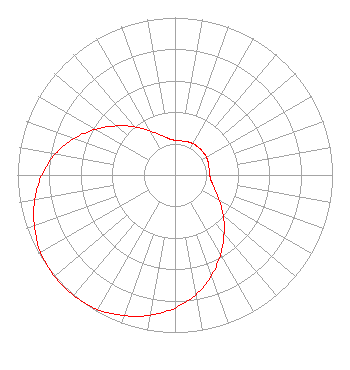 | ||||||||||||||||||
| Azimuth | Ratio | Azimuth | Ratio | Azimuth | Ratio | Azimuth | Ratio | ||||||||||||
| 0 | 0.220 | 10 | 0.220 | 20 | 0.225 | 30 | 0.230 | ||||||||||||
| 40 | 0.230 | 50 | 0.230 | 60 | 0.230 | 70 | 0.225 | ||||||||||||
| 80 | 0.220 | 90 | 0.220 | 100 | 0.235 | 110 | 0.270 | ||||||||||||
| 120 | 0.325 | 130 | 0.400 | 140 | 0.485 | 150 | 0.580 | ||||||||||||
| 160 | 0.680 | 170 | 0.770 | 180 | 0.845 | 190 | 0.905 | ||||||||||||
| 200 | 0.950 | 210 | 0.985 | 220 | 1.000 | 225 | 1.000 | ||||||||||||
| 230 | 1.000 | 240 | 0.985 | 250 | 0.950 | 260 | 0.905 | ||||||||||||
| 270 | 0.845 | 280 | 0.770 | 290 | 0.680 | 300 | 0.580 | ||||||||||||
| 310 | 0.485 | 320 | 0.400 | 330 | 0.325 | 340 | 0.270 | ||||||||||||
| 350 | 0.235 | ||||||||||||||||||
Structure Registration Number 1214099 Structure Type: TOWER Structure Address: 2828 Dupont Springs Rd Near Tower Rd Sevierville, TN County Name: Sevier County ASR Issued: 06/23/2000 Site Elevation: 797 m (2615 ft.) Structure Height: 54.9 m (180 ft.) Height Overall: 60.3 m (198 ft.) Overall Height AMSL: 857.3 m (2813 ft.) FAA Determination: 05/18/2000 FAA Study #: 00-ASO-2521-OE FAA Circular #: Paint & Light FAA Chapters: NONE PRIOR FAA 98-ASO-6678-OE 35-48-52.3 N 83-39-59.6 W (NAD 83) 35-48-52.0 N 83-39-60.0 W (Converted to NAD 27) |
Po Box 909 Plattsburgh, NY 12901 Phone: 518-490-9790 Limited Liability Company | Title: Managing Member Date: 09/20/2023 Application Certifier Loud Media Llc Po Box 909 Plattsburgh, NY 12901 Applicant Timothy G. Nelson Brooks, Pierce Et Al. 150 Fayetteville Street Suite 1700 Raleigh, NC 27601 | |||||||||||||||||