
FCCInfo.com
A Service of Cavell, Mertz & Associates, Inc.
(855) FCC-INFO
|
|
|
|
|
||||||||||||||||
|
|
WXRV-FM5 Channel: 223D 92.5 MHz Boston, Massachusetts Service: FB - A booster station or application for a booster. Facility ID: 198907 Fac. Service: FB Programming Delivery Method: Unspecified Status: Construction Permit Application Accepted: 12/08/2023 Application Granted: 01/17/2024 File Number: -0000232158 WXRV-FM5 CP Expires: 01/16/2027 Application Type: Minor Modification FCC Website Links: LMS Facility Details This Application Other WXRV-FM5 Applications Other WXRV-FM5 Applications in CDBS Including Superseded Applications Mailing Address Correspondence for WXRV-FM5 Correspondence related to application -0000232158 Service Contour - Open Street Map or USGS Map (60 dBu) Service Contour - KML / Google Earth (60 dBu) Facility Type: FM STATION Class: D, A Noncommercial educational operating with no more than 10W Site Location: 42-21-08.1 N 71-03-22.6 W (NAD 83) Site Location: 42-21-07.7 N 71-03-24.4 W (Converted to NAD 27) Effective Radiated Power: 0.06 kW Antenna Center HAAT: 0 m Antenna Center AMSL: 190.9 m (626 ft.) Antenna Center HAG: 186 m (610 ft.) Site Elevation: 4.9 m. (16 ft.) Height Overall*: 208.1 m (683 ft.) (* As Filed In This Application, may differ from ASR Data, Below.) Directional Antenna Antenna Make/Model: Shively 6025 Antenna ID: 0 Polarization: H
| ||||||||||||||||||
| Antenna Data for Antenna Id: 0 WXRV-FM5 FB File: -0000232158 Shively - 6025 Service: FB | 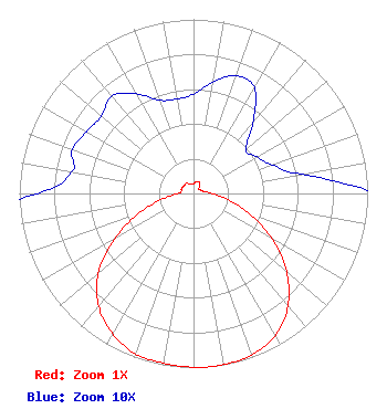 | ||||||||||||||||||
| Azimuth | Ratio | Azimuth | Ratio | Azimuth | Ratio | Azimuth | Ratio | ||||||||||||
| 0 | 0.057 | 10 | 0.065 | 20 | 0.072 | 30 | 0.070 | ||||||||||||
| 40 | 0.053 | 50 | 0.039 | 60 | 0.042 | 70 | 0.048 | ||||||||||||
| 80 | 0.063 | 90 | 0.108 | 100 | 0.200 | 110 | 0.344 | ||||||||||||
| 120 | 0.523 | 130 | 0.698 | 140 | 0.843 | 150 | 0.940 | ||||||||||||
| 160 | 0.985 | 170 | 0.998 | 175 | 1.000 | 180 | 0.998 | ||||||||||||
| 190 | 0.990 | 200 | 0.980 | 210 | 0.930 | 220 | 0.846 | ||||||||||||
| 230 | 0.713 | 240 | 0.526 | 250 | 0.333 | 260 | 0.177 | ||||||||||||
| 270 | 0.090 | 280 | 0.071 | 290 | 0.074 | 300 | 0.071 | ||||||||||||
| 310 | 0.069 | 320 | 0.073 | 330 | 0.066 | 340 | 0.057 | ||||||||||||
| 350 | 0.055 | ||||||||||||||||||
Structure Registration Number 1004488 Structure Type: BTWR Registered To: OFC REIT, LLC Structure Address: One Financial Center East Tower Boston, MA County Name: Suffolk County ASR Issued: 02/26/2021 Date Built: 12/25/2017 Site Elevation: 4.9 m (16 ft.) Structure Height: 182.5 m (599 ft.) Height Overall: 208.1 m (683 ft.) Overall Height AMSL: 213 m (699 ft.) FAA Determination: 05/25/2017 FAA Study #: 2017-ANE-962-OE Paint & Light FAA Chapters: NONE PRIOR STUDY 1996-ANE-91-OE 42-21-08.1 N 71-03-22.6 W (NAD 83) 42-21-07.7 N 71-03-24.4 W (Converted to NAD 27) |
288 South River Road Bedford, NH 03110 Phone: 603-668-6400 Corporation | Title: Engineer Date: 12/08/2023 Application Certifier BEANPOT LICENSE CORP. Beanpot License Corp. 288 South River Road Bedford, NH 03110 Applicant BARRY A FRIEDMAN Thompson Hine Llp Suite 700 1919 M Street, N.w. Washington, DC 20036 Attorney BERT GOLDMAN Goldman Engineering Management 560 Perkins Way Auburn, CA 95603 TECHNICAL CONSULTANT | |||||||||||||||||