
FCCInfo.com
A Service of Cavell, Mertz & Associates, Inc.
(855) FCC-INFO
|
|
KTSE-FM from 06/01/1993 KTSE-FM from 03/29/1993 |
|
|
||||||||||||||||
|
|
KTSE-FM Channel: 246A 97.1 MHz Patterson, California Service: FM - A full-service FM station or application. Facility ID: 29542 Fac. Service: FM Status: License 73.215 Station Application Accepted: 12/15/2023 Application Granted: 12/29/2023 File Number: -0000233221 License Expires: 12/01/2029 Application Type: License To Cover FCC Website Links: LMS Facility Details This Application Other KTSE-FM Applications Other KTSE-FM Applications in CDBS Including Superseded Applications Mailing Address Correspondence for KTSE-FM Correspondence related to application -0000233221 Service Contour - Open Street Map or USGS Map (60 dBu) Service Contour - KML / Google Earth (60 dBu) Public Inspection Files Facility Type: FM STATION Class: A, A Zone I; I-A; or II station; with 0.1kW-6kW ERP and a class contour distance <=28km Site Location: 37-37-29.0 N 121-24-01.0 W (NAD 83) Site Location: 37-37-29.2 N 121-23-57.2 W (Converted to NAD 27) Effective Radiated Power: 4.4 kW Transmitter Output Power: 0.99 kW Antenna Center HAAT: 89 m (292 ft.) Antenna Center AMSL: 294 m (965 ft.) Antenna Center HAG: 99 m (325 ft.) Site Elevation: 195.4 m. (641 ft.) Height Overall*: 114 m (374 ft.) (* As Filed In This Application, may differ from ASR Data, Below.) Directional Antenna Antenna Make/Model: Propagation System Inc PSIFMR-4E-DA Antenna ID: 1011329 Polarization: | ||||||||||||||||||
| Antenna Data for Antenna Id: 1011329 KTSE-FM FM File: -0000233221 Propagation System Inc - PSIFMR-4E-DA Service: FM | 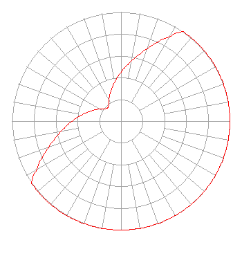 | ||||||||||||||||||
| Azimuth | Ratio | Azimuth | Ratio | Azimuth | Ratio | Azimuth | Ratio | ||||||||||||
| 0 | 0.447 | 10 | 0.562 | 20 | 0.708 | 30 | 0.891 | ||||||||||||
| 35 | 1.000 | 40 | 1.000 | 50 | 1.000 | 60 | 1.000 | ||||||||||||
| 70 | 1.000 | 80 | 1.000 | 90 | 1.000 | 100 | 1.000 | ||||||||||||
| 110 | 1.000 | 120 | 1.000 | 130 | 1.000 | 140 | 1.000 | ||||||||||||
| 150 | 1.000 | 160 | 1.000 | 170 | 1.000 | 180 | 1.000 | ||||||||||||
| 190 | 1.000 | 200 | 1.000 | 210 | 1.000 | 220 | 1.000 | ||||||||||||
| 230 | 1.000 | 235 | 1.000 | 240 | 0.891 | 250 | 0.708 | ||||||||||||
| 260 | 0.562 | 270 | 0.447 | 280 | 0.355 | 290 | 0.282 | ||||||||||||
| 300 | 0.224 | 310 | 0.178 | 320 | 0.178 | 330 | 0.224 | ||||||||||||
| 340 | 0.282 | 350 | 0.355 | ||||||||||||||||
Structure Registration Number 1015788 Structure Type: GTOWER Registered To: Entravision Communications Corporation Structure Address: 35251 Chrisman Rd Tracy, CA County Name: San Joaquin County ASR Issued: 10/10/2012 Date Built: 01/20/1990 Site Elevation: 195.4 m (641 ft.) Structure Height: 113 m (371 ft.) Height Overall: 114 m (374 ft.) Overall Height AMSL: 309.4 m (1015 ft.) FAA Determination: 01/15/2003 FAA Study #: 2003-AWP-57-OE FAA Circular #: 70/7460-1J Paint & Light FAA Chapters: 3, 4, 5, 13 PRIOR STUDY 1997-AWP-2062-OE 37-37-29.0 N 121-24-01.0 W (NAD 83) 37-37-29.2 N 121-23-57.2 W (Converted to NAD 27) |
2425 Olympic Blvd Ste 6000 W Santa Monica, CA 90404 Phone: 310-447-3870 Limited Liability Company | Title: President/coo Date: 12/15/2023 Application Certifier ENTRAVISION HOLDINGS, LLC Entravision Holdings, Llc 2425 Olympic Blvd Ste 6000 W Santa Monica, CA 90404 Applicant Ari Meltzer Wiley Rein Llp 2050 M Street Nw Washington, DC 20036 Erik C Swanson, PE Hatfield & Dawson 9500 Greenwood Ave N Seattle, WA 98103 Consulting Engineer | |||||||||||||||||
| |||||||||||||||||||