
FCCInfo.com
A Service of Cavell, Mertz & Associates, Inc.
(855) FCC-INFO
|
|
W202AW from 05/17/1996 |
|
|
||||||||||||||||
|
|
W202AW Channel: 216D 91.1 MHz Sandusky, Ohio Service: FX - A translator or application for a translator. Facility ID: 77850 Fac. Service: FX Programming Delivery Method: Unspecified Status: Construction Permit Application Accepted: 12/29/2023 Application Granted: 01/18/2024 File Number: -0000234381 W202AW CP Expires: 01/18/2027 Application Type: Minor Modification FCC Website Links: LMS Facility Details This Application Other W202AW Applications Other W202AW Applications in CDBS Including Superseded Applications Mailing Address Correspondence for W202AW Correspondence related to application -0000234381 Service Contour - Open Street Map or USGS Map (60 dBu) Service Contour - KML / Google Earth (60 dBu) Facility Type: NON-COMMERCIAL EDUC. FM Class: D, A Noncommercial educational operating with no more than 10W Site Location: 41-23-58.0 N 82-39-07.0 W (NAD 83) Site Location: 41-23-57.8 N 82-39-07.4 W (Converted to NAD 27) Effective Radiated Power: 0.2 kW Antenna Center HAAT: 0 m Antenna Center AMSL: 215 m (705 ft.) Antenna Center HAG: 30 m (98 ft.) Site Elevation: 185 m. (607 ft.) Height Overall*: 83.5 m (274 ft.) (* As Filed In This Application, may differ from ASR Data, Below.) Directional Antenna Antenna Make/Model: Nicom USA, Inc. BKG77/2DA(0.85WL) Antenna ID: 30889 Polarization: H
| ||||||||||||||||||
| Antenna Data for Antenna Id: 30889 W202AW FX File: -0000234381 Nicom USA, Inc. - BKG77/2DA(0.85WL) Service: FX | 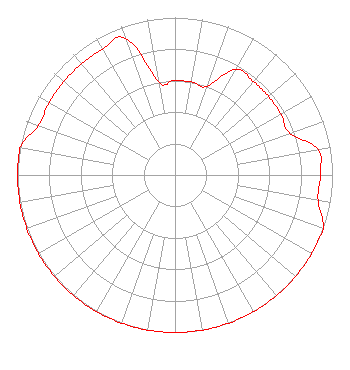 | ||||||||||||||||||
| Azimuth | Ratio | Azimuth | Ratio | Azimuth | Ratio | Azimuth | Ratio | ||||||||||||
| 0 | 0.600 | 10 | 0.600 | 20 | 0.600 | 30 | 0.775 | ||||||||||||
| 40 | 0.775 | 50 | 0.775 | 60 | 0.775 | 70 | 0.775 | ||||||||||||
| 80 | 0.922 | 90 | 0.922 | 100 | 0.922 | 110 | 1.000 | ||||||||||||
| 120 | 1.000 | 130 | 1.000 | 140 | 1.000 | 150 | 1.000 | ||||||||||||
| 160 | 1.000 | 170 | 1.000 | 180 | 1.000 | 190 | 1.000 | ||||||||||||
| 200 | 1.000 | 210 | 1.000 | 220 | 1.000 | 230 | 1.000 | ||||||||||||
| 240 | 1.000 | 250 | 1.000 | 260 | 1.000 | 270 | 1.000 | ||||||||||||
| 280 | 1.000 | 290 | 0.922 | 300 | 0.922 | 310 | 0.922 | ||||||||||||
| 320 | 0.922 | 330 | 0.922 | 340 | 0.922 | 350 | 0.600 | ||||||||||||
Structure Registration Number 1060431 Structure Type: Registered To: PERKINS, TOWNSHIP OF Structure Address: Int Of Us 250 & Sr 2 Sandusky, OH County Name: Erie County ASR Issued: 08/10/2022 Date Built: 05/06/1999 Site Elevation: 185 m (607 ft.) Structure Height: 81 m (266 ft.) Height Overall: 83.5 m (274 ft.) Overall Height AMSL: 268.5 m (881 ft.) FAA Determination: 05/29/1998 FAA Study #: 97-AGL-5722-OE FAA Circular #: 70/7460-1J Paint & Light FAA Chapters: 4, 8, 13 41-23-58.0 N 82-39-07.0 W (NAD 83) 41-23-57.8 N 82-39-07.4 W (Converted to NAD 27) |
11530 Carmel Commons Blvd Charlotte, NC 28226 Phone: 704-523-5555 Not-for-Profit | Title: Secretary-treasurer Date: 12/29/2023 Application Certifier BIBLE BROADCASTING NETWORK, INC. Bible Broadcasting Network, Inc. 11530 Carmel Commons Blvd Charlotte, NC 28226 Applicant Justin Asher Asher Broadcast Consulting, Llc 579 Babcock Road Bronson, MI 49028 Technical Consultant GARY S. SMITHWICK, ESQ Smithwick & Belendiuk, P.c. 5028 Wisconsin Avenue, Nw Suite 301 Washington, DC 20016 COUNSEL | |||||||||||||||||