
FCCInfo.com
A Service of Cavell, Mertz & Associates, Inc.
(855) FCC-INFO
|
|
|
|  |
|
|||||||||||||||
|
|
KXCI Channel: 217C2 91.3 MHz Tucson, Arizona Service: FS - A full service FM station auxiliary transmitting antenna or application. Facility ID: 22167 Fac. Service: FM Analog & Digital Status: License Application Accepted: 03/06/2024 Application Granted: 04/04/2024 File Number: -0000240465 License Expires: 10/01/2029 Application Type: License To Cover FCC Website Links: LMS Facility Details This Application Other KXCI Applications Other KXCI Applications in CDBS Including Superseded Applications Mailing Address Correspondence for KXCI Correspondence related to application -0000240465 Service Contour - Open Street Map or USGS Map (60 dBu) Service Contour - KML / Google Earth (60 dBu) Public Inspection Files Facility Type: NON-COMMERCIAL EDUC. FM Class: C2, A Zone II station; with 25kW-50kW ERP and a class contour distance 39km-52km Site Location: 32-15-11.3 N 110-57-45.9 W (NAD 83) Site Location: 32-15-11.0 N 110-57-43.6 W (Converted to NAD 27) Effective Radiated Power: 8.5 kW Transmitter Output Power: 8 kW Antenna Center HAAT: 9 m (30 ft.) Antenna Center AMSL: 812 m (2664 ft.) Antenna Center HAG: 83 m (272 ft.) Site Elevation: 729.4 m. (2393 ft.) Height Overall*: 87.8 m (288 ft.) (* As Filed In This Application, may differ from ASR Data, Below.) Directional Antenna Antenna Make/Model: Shively 6810-2-SS-DA,2 sections Antenna ID: 116684 Polarization: H | ||||||||||||||||||
| Antenna Data for Antenna Id: 116684 KXCI FS File: -0000240465 Shively - 6810-2-SS-DA,2 sections Service: FS | 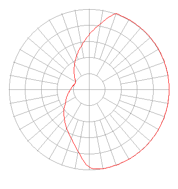 | ||||||||||||||||||
| Azimuth | Ratio | Azimuth | Ratio | Azimuth | Ratio | Azimuth | Ratio | ||||||||||||
| 0 | 0.678 | 10 | 0.830 | 20 | 1.000 | 30 | 1.000 | ||||||||||||
| 40 | 1.000 | 50 | 1.000 | 60 | 1.000 | 70 | 1.000 | ||||||||||||
| 80 | 1.000 | 90 | 1.000 | 100 | 1.000 | 110 | 1.000 | ||||||||||||
| 120 | 1.000 | 130 | 1.000 | 140 | 1.000 | 150 | 1.000 | ||||||||||||
| 160 | 1.000 | 170 | 1.000 | 180 | 0.964 | 190 | 0.781 | ||||||||||||
| 200 | 0.649 | 210 | 0.560 | 220 | 0.479 | 230 | 0.409 | ||||||||||||
| 240 | 0.340 | 250 | 0.300 | 260 | 0.260 | 270 | 0.230 | ||||||||||||
| 280 | 0.210 | 290 | 0.192 | 300 | 0.192 | 310 | 0.234 | ||||||||||||
| 320 | 0.289 | 330 | 0.360 | 340 | 0.447 | 350 | 0.547 | ||||||||||||
Structure Registration Number 1009810 Structure Type: GTOWER Registered To: SBA Towers X, LLC Structure Address: 2550 N Los Altos Ave (az23889-a) Tucson, AZ County Name: Pima County ASR Issued: 12/10/2019 Date Built: 06/24/2013 Site Elevation: 729.4 m (2393 ft.) Structure Height: 85.3 m (280 ft.) Height Overall: 87.8 m (288 ft.) Overall Height AMSL: 817.2 m (2681 ft.) FAA Determination: 11/25/2019 FAA Study #: 2019-AWP-12738-OE FAA Circular #: 70/7460-1L Paint & Light FAA Chapters: 4, 8, 12 Chapters 4, 8, 12, Circular Number 70/7460-1L 32-15-11.3 N 110-57-45.9 W (NAD 83) 32-15-11.0 N 110-57-43.6 W (Converted to NAD 27) |
220 South Fourth Avenue Tucson, AZ 85701 Phone: 520-623-1000 Not-for-Profit | Title: Executive Director Date: 03/06/2024 Application Certifier FOUNDATION FOR CREATIVE BROADCASTING, INC. Foundation For Creative Broadcasting, Inc. 220 South Fourth Avenue Tucson, AZ 85701 Applicant Bert Goldman Goldman Engineering Management 560 Perkins Way Auburn, CA 95603 Technical Consultant Cary S. Tepper Tepper Law Firm, Llc 4900 Auburn Avenue Suite 100 Bethesda, MD 20814 Communications Counsel | |||||||||||||||||
| |||||||||||||||||||