
FCCInfo.com
A Service of Cavell, Mertz & Associates, Inc.
(855) FCC-INFO
|
|
|
|
|
||||||||||||||||
|
|
K201FX Channel: 201D 88.1 MHz Reno, Texas Service: FX - A translator or application for a translator. Facility ID: 93759 Fac. Service: FX Programming Delivery Method: Unspecified Status: Construction Permit Application Accepted: 04/04/2024 Application Granted: 04/24/2024 File Number: -0000243020 K201FX CP Expires: 04/24/2027 Application Type: Minor Modification FCC Website Links: LMS Facility Details This Application Other K201FX Applications Other K201FX Applications in CDBS Including Superseded Applications Mailing Address Correspondence for K201FX Correspondence related to application -0000243020 Service Contour - Open Street Map or USGS Map (60 dBu) Service Contour - KML / Google Earth (60 dBu) Facility Type: NON-COMMERCIAL EDUC. FM Class: D, A Noncommercial educational operating with no more than 10W Site Location: 33-37-10.0 N 95-32-51.0 W (NAD 83) Site Location: 33-37-09.6 N 95-32-50.2 W (Converted to NAD 27) Effective Radiated Power: 0 kW Horiz. ; 0.092 kW Vert. Antenna Center HAAT: 0 m Horiz.; 148.7 m Vert. Antenna Center AMSL: 0 m Horiz.; 299.6 m Vert. Antenna Center HAG: 0 m Horiz.; 132 m Vert. Site Elevation: 167.6 m. (550 ft.) Height Overall*: 189.9 m (623 ft.) (* As Filed In This Application, may differ from ASR Data, Below.) Directional Antenna Antenna Make/Model: TELEWAVE ANT90D Antenna ID: 69732 Polarization: H
| ||||||||||||||||||
| Antenna Data for Antenna Id: 69732 K201FX FX File: -0000243020 TELEWAVE - ANT90D Service: FX | 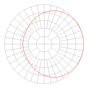 | ||||||||||||||||||
| Azimuth | Ratio | Azimuth | Ratio | Azimuth | Ratio | Azimuth | Ratio | ||||||||||||
| 0 | 0.792 | 10 | 0.845 | 20 | 0.892 | 30 | 0.929 | ||||||||||||
| 40 | 0.956 | 50 | 0.975 | 60 | 0.987 | 70 | 0.995 | ||||||||||||
| 80 | 0.999 | 90 | 1.000 | 100 | 0.999 | 110 | 0.995 | ||||||||||||
| 120 | 0.987 | 130 | 0.975 | 140 | 0.956 | 150 | 0.929 | ||||||||||||
| 160 | 0.892 | 170 | 0.845 | 180 | 0.792 | 190 | 0.735 | ||||||||||||
| 200 | 0.679 | 210 | 0.630 | 220 | 0.592 | 230 | 0.566 | ||||||||||||
| 240 | 0.549 | 250 | 0.540 | 260 | 0.535 | 270 | 0.534 | ||||||||||||
| 280 | 0.535 | 290 | 0.540 | 300 | 0.549 | 310 | 0.566 | ||||||||||||
| 320 | 0.592 | 330 | 0.630 | 340 | 0.679 | 350 | 0.735 | ||||||||||||
Structure Registration Number 1051945 Structure Type: TOWER Registered To: AIRWAVES COMMUNICATIONS INC Structure Address: 1.6 Km S Of S Loop 286 On Cr 11300 Paris, TX County Name: Lamar County ASR Issued: 08/04/2000 Date Built: 01/01/1983 Site Elevation: 167.6 m (550 ft.) Structure Height: 183.8 m (603 ft.) Height Overall: 189.9 m (623 ft.) Overall Height AMSL: 357.5 m (1173 ft.) FAA Determination: 01/08/1997 FAA Study #: 97-ASW-0081-OE FAA Circular #: 70/7460-1H Paint & Light FAA Chapters: 3, 4, 5, 13 33-37-10.0 N 95-32-51.0 W (NAD 83) 33-37-09.6 N 95-32-50.2 W (Converted to NAD 27) |
4002 N. 3300 E. Twin Falls, ID 83301 Phone: 208-734-6633 Not-for-Profit | Title: President Date: 04/04/2024 Application Certifier CSN INTERNATIONAL Csn International 4002 N. 3300 E. Twin Falls, ID 83301 Applicant Scott Spencer Csn International 4002 N. 3300 E. Twin Falls, ID 83301 APPLICATIONS TECHNICIAN Cary Tepper Tepper Law, Llc 4900 Auburn St. Suite 100 Bethesda, MD 20814 | |||||||||||||||||