
FCCInfo.com
A Service of Cavell, Mertz & Associates, Inc.
(855) FCC-INFO
|
|
|
|
|
||||||||||||||||
|
|
W232DK Channel: 232D 94.3 MHz Auburn, Indiana Service: FX - A translator or application for a translator. Facility ID: 200698 Fac. Service: FX Programming Delivery Method: Unspecified Status: License Application Accepted: 09/19/2018 Application Granted: 10/03/2018 File Number: BLFT-20180919ABL License Expires: 00/00/0000 Prefix Type: This is a license for a translator Application Type: License To Cover FCC Website Links: LMS Facility Details This Application CDBS Application Other W232DK Applications Other W232DK Applications in CDBS Including Superseded Applications Mailing Address Correspondence for W232DK Correspondence related to application BLFT-20180919ABL Service Contour - Open Street Map or USGS Map (60 dBu) Service Contour - KML / Google Earth (60 dBu) Class: D, A Noncommercial educational operating with no more than 10W Site Location: 41-24-25.2 N 85-02-04.9 W (NAD 83) Site Location: 41-24-25.0 N 85-02-05.0 W (Converted to NAD 27) Effective Radiated Power: 0.25 kW Transmitter Output Power: 0.867 kW Antenna Center HAAT: 0 m Antenna Center AMSL: 361 m (1184 ft.) Antenna Center HAG: 88 m (289 ft.) Site Elevation: 273 m. (896 ft.) Height Overall*: 92 m (302 ft.) (* As Filed In This Application, may differ from ASR Data, Below.) Directional Antenna Antenna Make/Model: None Antenna ID: 130040 Polarization:
| ||||||||||||||||||
| Antenna Data for Antenna Id: 130040 W232DK FX File: BLFT-20180919ABL None - Service: FX | 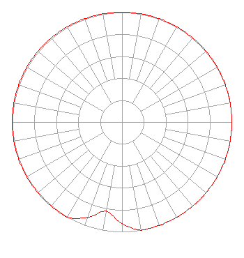 | ||||||||||||||||||
| Azimuth | Ratio | Azimuth | Ratio | Azimuth | Ratio | Azimuth | Ratio | ||||||||||||
| 0 | 1.000 | 10 | 1.000 | 20 | 1.000 | 30 | 1.000 | ||||||||||||
| 40 | 1.000 | 50 | 1.000 | 60 | 1.000 | 70 | 1.000 | ||||||||||||
| 80 | 1.000 | 90 | 1.000 | 100 | 1.000 | 110 | 1.000 | ||||||||||||
| 120 | 1.000 | 130 | 1.000 | 140 | 1.000 | 150 | 1.000 | ||||||||||||
| 160 | 1.000 | 170 | 1.000 | 180 | 0.925 | 190 | 0.825 | ||||||||||||
| 200 | 0.925 | 210 | 1.000 | 220 | 1.000 | 230 | 1.000 | ||||||||||||
| 240 | 1.000 | 250 | 1.000 | 260 | 1.000 | 270 | 1.000 | ||||||||||||
| 280 | 1.000 | 290 | 1.000 | 300 | 1.000 | 310 | 1.000 | ||||||||||||
| 320 | 1.000 | 330 | 1.000 | 340 | 1.000 | 350 | 1.000 | ||||||||||||
Structure Registration Number 1281871 Structure Type: TOWER Registered To: City of Auburn Structure Address: 3397 Co Rd 34 Waterloo, IN County Name: DeKalb County ASR Issued: 12/15/2011 Date Built: 07/15/2010 Site Elevation: 272.8 m (895 ft.) Structure Height: 91.7 m (301 ft.) Height Overall: 91.7 m (301 ft.) Overall Height AMSL: 364.5 m (1196 ft.) FAA Determination: 09/29/2011 FAA Study #: 2011-AGL-4985-OE FAA Circular #: 70/7460-1K Paint & Light FAA Chapters: 4, 8, 12 PRIOR STUDY 2010-AGL-138-OE 41-24-25.4 N 85-02-04.4 W (NAD 83) 41-24-25.2 N 85-02-04.5 W (Converted to NAD 27) |
931 East Avenue Kendallville, IN 46755 Phone: 260-347-2400 | Date: 09/19/2018 Application Certifier NORTHEAST INDIANA BROADCASTING, INC. 931 East Avenue Kendallville, IN 46755 Applicant JUSTIN ASHER Asher Broadcast Consulting, Llc 579 Babcock Road Bronson, MI 49028-9347 TECHNICAL CONSULTANT MATTHEW H. MCCORMICK, ESQUIRE Fletcher, Heald & Hildreth, Plc 1300 North 17th Street 11th Floor Arlington, VA 22209 | |||||||||||||||||