
FCCInfo.com
A Service of Cavell, Mertz & Associates, Inc.
(855) FCC-INFO
|
|
|
|
|
||||||||||||||||
|
|
WBJC Channel: 218B 91.5 MHz Baltimore, Maryland Service: FM - A full-service FM station or application. Facility ID: 3654 Fac. Service: FM Analog & Digital Status: License Application Accepted: 11/09/2010 Application Granted: 11/16/2010 File Number: BLED-20101109ABJ License Expires: 00/00/0000 Prefix Type: This is a license for a noncommercial educational FM station Application Type: License To Cover FCC Website Links: LMS Facility Details This Application CDBS Application Other WBJC Applications Other WBJC Applications in CDBS Including Superseded Applications Mailing Address Correspondence for WBJC Correspondence related to application BLED-20101109ABJ Service Contour - Open Street Map or USGS Map (60 dBu) Service Contour - KML / Google Earth (60 dBu) Public Inspection Files History Cards for WBJC Facility Type: NON-COMMERCIAL EDUC. FM Class: B, A Zone I or I-A station; with 25kW-50kW ERP and a class contour distance 39km-52km Site Location: 39-23-11.4 N 76-43-50.9 W (NAD 83) Site Location: 39-23-11.0 N 76-43-52.0 W (Converted to NAD 27) Effective Radiated Power: 50 kW Transmitter Output Power: 16.85 kW Antenna Center HAAT: 152 m (499 ft.) Antenna Center AMSL: 289.2 m (949 ft.) Antenna Center HAG: 120 m (394 ft.) Calculated Site Elevation: 169.2 m. (555 ft.) Height Overall*: 126.8 m (416 ft.) (* As Filed In This Application, may differ from ASR Data, Below.) Directional Antenna Antenna Make/Model: Electronics Research Inc. MP-8C-DA-HW, 8 section, 0.5 wavelength spaced Antenna ID: 80640 Polarization: | ||||||||||||||||||
| Antenna Data for Antenna Id: 80640 WBJC FM File: BLED-20101109ABJ Electronics Research Inc. - MP-8C-DA-HW, 8 section, 0.5 wavelength spaced Service: FM | 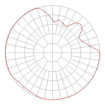 | ||||||||||||||||||
| Azimuth | Ratio | Azimuth | Ratio | Azimuth | Ratio | Azimuth | Ratio | ||||||||||||
| 0 | 0.690 | 5 | 0.650 | 10 | 0.700 | 20 | 0.650 | ||||||||||||
| 25 | 0.630 | 30 | 0.650 | 40 | 0.818 | 50 | 0.818 | ||||||||||||
| 60 | 0.650 | 70 | 0.680 | 80 | 0.800 | 90 | 1.000 | ||||||||||||
| 100 | 1.000 | 110 | 1.000 | 120 | 1.000 | 130 | 1.000 | ||||||||||||
| 140 | 1.000 | 150 | 1.000 | 160 | 1.000 | 170 | 1.000 | ||||||||||||
| 180 | 1.000 | 190 | 1.000 | 200 | 0.977 | 210 | 0.950 | ||||||||||||
| 220 | 0.950 | 230 | 0.950 | 240 | 1.000 | 250 | 1.000 | ||||||||||||
| 260 | 1.000 | 270 | 1.000 | 280 | 1.000 | 290 | 1.000 | ||||||||||||
| 300 | 1.000 | 310 | 1.000 | 320 | 1.000 | 330 | 1.000 | ||||||||||||
| 340 | 1.000 | 350 | 0.868 | ||||||||||||||||
Structure Registration Number 1036002 Structure Type: TOWER Registered To: BALTIMORE CITY COMMUNITY COLLEGE Structure Address: 322 Meters E Int I-695 & Us Hwy 140 Pikesville, MD County Name: Baltimore County ASR Issued: 01/20/1998 Date Built: 01/01/1978 Site Elevation: 169.2 m (555 ft.) Structure Height: 110.3 m (362 ft.) Height Overall: 126.8 m (416 ft.) Overall Height AMSL: 296 m (971 ft.) FAA Determination: 02/03/1976 FAA Study #: 76-EA-105-OE Paint & Light FAA Chapters: 1, 3, 12, 21 RED LIGHTS/PAINT 39-23-11.0 N 76-43-51.0 W (NAD 83) 39-23-10.6 N 76-43-52.1 W (Converted to NAD 27) |
2901 Liberty Heights Avenue Baltimore, MD 21215 Government Entity | Date: 11/09/2010 Application Certifier BALTIMORE CITY COMMUNITY COLLEGE 2901 Liberty Heights Ave Baltimore, MD 21215 Applicant CHARLES L. SPENCER Hebert, Spencer, Cusimano & Fry, Llp ARTHUR M. HOOVER, III 1201f Cloverland Court Baton Rouge, LA 70809 TECHNICAL CONSULTANT | |||||||||||||||||
| |||||||||||||||||||