
FCCInfo.com
A Service of Cavell, Mertz & Associates, Inc.
(855) FCC-INFO
|
|
K292GW from 10/20/2006 K292GW from 06/07/2004 |
|
|
||||||||||||||||
|
|
K292GW Channel: 292D 106.3 MHz Boulder, Colorado Service: FX - A translator or application for a translator. Facility ID: 154262 Fac. Service: FX Programming Delivery Method: Unspecified Status: License Application Accepted: 05/25/2016 Application Granted: 06/20/2016 File Number: BLFT-20160525ADA License Expires: 00/00/0000 Prefix Type: This is a license for a translator Application Type: License To Cover FCC Website Links: LMS Facility Details This Application CDBS Application Other K292GW Applications Other K292GW Applications in CDBS Including Superseded Applications Mailing Address Correspondence for K292GW Correspondence related to application BLFT-20160525ADA Service Contour - Open Street Map or USGS Map (60 dBu) Service Contour - KML / Google Earth (60 dBu) Class: D, A Noncommercial educational operating with no more than 10W Site Location: 40-00-42.9 N 105-11-18.0 W (NAD 83) Site Location: 40-00-43.0 N 105-11-16.0 W (Converted to NAD 27) Effective Radiated Power: 0.25 kW Transmitter Output Power: 0.09 kW Antenna Center HAAT: 0 m Antenna Center AMSL: 1670 m (5479 ft.) Antenna Center HAG: 45 m (148 ft.) Site Elevation: 1625 m. (5331 ft.) Height Overall*: 51 m (167 ft.) (* As Filed In This Application, may differ from ASR Data, Below.) Directional Antenna Antenna Make/Model: None Antenna ID: 123680 Polarization:
| ||||||||||||||||||
| Antenna Data for Antenna Id: 123680 K292GW FX File: BLFT-20160525ADA None - Service: FX | 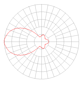 | ||||||||||||||||||
| Azimuth | Ratio | Azimuth | Ratio | Azimuth | Ratio | Azimuth | Ratio | ||||||||||||
| 0 | 0.157 | 10 | 0.181 | 20 | 0.187 | 30 | 0.171 | ||||||||||||
| 40 | 0.140 | 50 | 0.123 | 60 | 0.135 | 70 | 0.160 | ||||||||||||
| 80 | 0.182 | 90 | 0.193 | 100 | 0.182 | 110 | 0.160 | ||||||||||||
| 120 | 0.135 | 130 | 0.123 | 140 | 0.140 | 150 | 0.171 | ||||||||||||
| 160 | 0.187 | 170 | 0.181 | 180 | 0.157 | 190 | 0.142 | ||||||||||||
| 200 | 0.134 | 210 | 0.190 | 220 | 0.329 | 230 | 0.528 | ||||||||||||
| 240 | 0.718 | 250 | 0.866 | 260 | 0.952 | 270 | 1.000 | ||||||||||||
| 280 | 0.952 | 290 | 0.866 | 300 | 0.718 | 310 | 0.528 | ||||||||||||
| 320 | 0.329 | 330 | 0.190 | 340 | 0.134 | 350 | 0.142 | ||||||||||||
Structure Registration Number 1024061 [ASR Heights Differ from K292GW Application] Structure Type: Registered To: RF Towers, LLC Structure Address: 5 Mi E Boulder, CO County Name: Boulder County ASR Issued: 02/10/2024 Date Built: 01/01/1997 Site Elevation: 1624.5 m (5330 ft.) Structure Height: 45.7 m (150 ft.) Height Overall: 50.9 m (167 ft.) Overall Height AMSL: 1675.4 m (5497 ft.) FAA Determination: 04/01/1997 FAA Study #: 97-ANM-0422-OE FAA Circular #: 70/7460-1J Paint & Light FAA Chapters: 3, 4, 5, 13 40-00-43.0 N 105-11-18.0 W (NAD 83) 40-00-43.1 N 105-11-16.0 W (Converted to NAD 27) |
7409 S. Alton Ct. Centennial, CO 80112 Phone: 303-871-9191 | Date: 05/25/2016 Application Certifier CEDAR COVE BROADCASTING, INC 87 Jasper Lake Road Loveland, CO 80537 Applicant VICTOR A MICHAEL, JR. 87 Jasper Lake Road Loveland, CO 80537 TECHNICAL CONSULTANT VICTOR MICHAEL Cedar Cove Broadcasting, Inc. 87 Jasper Lake Road Loveland, CO 80537 | |||||||||||||||||