
FCCInfo.com
A Service of Cavell, Mertz & Associates, Inc.
(855) FCC-INFO
|
|
KQMT from 03/22/1996 |
|
|
||||||||||||||||
|
|
KQMT Channel: 258C 99.5 MHz Denver, Colorado Service: FS - A full service FM station auxiliary transmitting antenna or application. Facility ID: 26929 Fac. Service: FM Analog & Digital Status: License Application Accepted: 06/18/2018 Application Granted: 06/19/2018 File Number: BXLH-20180618AAW License Expires: 00/00/0000 Prefix Type: This is BXLH Application Type: License To Cover FCC Website Links: LMS Facility Details This Application CDBS Application Other KQMT Applications Other KQMT Applications in CDBS Including Superseded Applications Mailing Address Correspondence for KQMT Correspondence related to application BXLH-20180618AAW Service Contour - Open Street Map or USGS Map (60 dBu) Service Contour - KML / Google Earth (60 dBu) Public Inspection Files History Cards for KQMT Facility Type: FM STATION Class: C, A Zone II station; with exactly 100kW ERP and a class contour distance 72km-92km Site Location: 39-40-17.0 N 105-13-08.0 W (NAD 83) Site Location: 39-40-17.0 N 105-13-06.0 W (Converted to NAD 27) Effective Radiated Power: 33 kW Transmitter Output Power: 10.14 kW Antenna Center HAAT: 353 m (1158 ft.) Antenna Center AMSL: 2384 m (7822 ft.) Antenna Center HAG: 41 m (135 ft.) Calculated Site Elevation: 2343 m. (7687 ft.) Height Overall*: 84 m (276 ft.) (* As Filed In This Application, may differ from ASR Data, Below.) Directional Antenna Antenna Make/Model: Electronics Research Inc. 1051-2CP-DA-SP Antenna ID: 125837 Polarization: | ||||||||||||||||||
| Antenna Data for Antenna Id: 125837 KQMT FS File: BXLH-20180618AAW Electronics Research Inc. - 1051-2CP-DA-SP Service: FS | 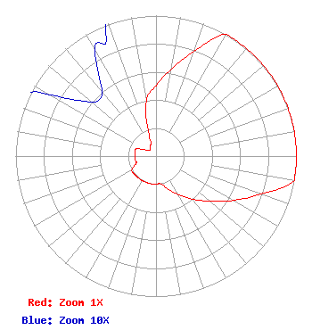 | ||||||||||||||||||
| Azimuth | Ratio | Azimuth | Ratio | Azimuth | Ratio | Azimuth | Ratio | ||||||||||||
| 0 | 0.501 | 10 | 0.631 | 20 | 0.794 | 30 | 1.000 | ||||||||||||
| 40 | 1.000 | 50 | 1.000 | 60 | 1.000 | 70 | 1.000 | ||||||||||||
| 80 | 1.000 | 90 | 1.000 | 100 | 1.000 | 110 | 0.794 | ||||||||||||
| 120 | 0.631 | 130 | 0.501 | 140 | 0.398 | 150 | 0.316 | ||||||||||||
| 160 | 0.251 | 170 | 0.200 | 180 | 0.200 | 190 | 0.200 | ||||||||||||
| 200 | 0.200 | 210 | 0.200 | 220 | 0.200 | 230 | 0.200 | ||||||||||||
| 240 | 0.200 | 250 | 0.150 | 260 | 0.150 | 270 | 0.150 | ||||||||||||
| 280 | 0.150 | 290 | 0.150 | 300 | 0.087 | 310 | 0.060 | ||||||||||||
| 320 | 0.060 | 330 | 0.087 | 340 | 0.120 | 350 | 0.398 | ||||||||||||
Structure Registration Number 1023484 [ASR Heights Differ from KQMT Application] Structure Type: TOWER Registered To: Bear Creek Development Corporation Structure Address: 2524 South Grapevine Road Idledale, CO County Name: Jefferson County ASR Issued: 04/07/2016 Date Built: 11/08/1988 Site Elevation: 2342.6 m (7686 ft.) Structure Height: 82.9 m (272 ft.) Height Overall: 83.5 m (274 ft.) Overall Height AMSL: 2426.1 m (7960 ft.) FAA Determination: 10/16/2003 FAA Study #: 2003-ANM-2104-OE FAA Circular #: 70/7460-1G Paint & Light FAA Chapters: 3, 4, 5, 9 PRIOR STUDY 1988-ANM-225-OE 39-40-17.4 N 105-13-08.0 W (NAD 83) 39-40-17.4 N 105-13-06.0 W (Converted to NAD 27) |
2400 Market Street 4th Floor Philadelphia, PA 19103 Phone: 610-660-5610 Limited Liability Company | Date: 06/18/2018 Application Certifier ENTERCOM LICENSE, LLC 401 E. City Avenue, Suite 809 Bala Cynwyd, PA 19004 Applicant ERIK C. SWANSON, P.E. Hatfield & Dawson Consulting Engineers, 9500 Greenwood Ave N Seattle, WA 98103 CONSULTING ENGINEER LAURA M. BERMAN Entercom Communications Corp. | |||||||||||||||||
| |||||||||||||||||||