
FCCInfo.com
A Service of Cavell, Mertz & Associates, Inc.
(855) FCC-INFO
|
|
|
|
|
||||||||||||||||
|
|
K226CT Channel: 226D 93.1 MHz Lewiston, Idaho Service: FX - A translator or application for a translator. Facility ID: 202297 Fac. Service: FX Programming Delivery Method: Unspecified Status: License (Licensed And Silent) Application Accepted: 10/25/2018 Application Granted: 10/31/2018 File Number: BLFT-20181025AAQ License Expires: 00/00/0000 Prefix Type: This is a license for a translator Application Type: License To Cover FCC Website Links: LMS Facility Details This Application CDBS Application Other K226CT Applications Other K226CT Applications in CDBS Including Superseded Applications Mailing Address Correspondence for K226CT Correspondence related to application BLFT-20181025AAQ Service Contour - Open Street Map or USGS Map (60 dBu) Service Contour - KML / Google Earth (60 dBu) Class: D, A Noncommercial educational operating with no more than 10W Site Location: 46-27-32.6 N 117-02-21.6 W (NAD 83) Site Location: 46-27-33.0 N 117-02-18.0 W (Converted to NAD 27) Effective Radiated Power: 0.25 kW Transmitter Output Power: 0.69 kW Antenna Center HAAT: 0 m Antenna Center AMSL: 927 m (3041 ft.) Antenna Center HAG: 49 m (161 ft.) Site Elevation: 878 m. (2881 ft.) Height Overall*: 96 m (315 ft.) (* As Filed In This Application, may differ from ASR Data, Below.) Directional Antenna Antenna Make/Model: None Antenna ID: 132229 Polarization:
| ||||||||||||||||||
| Antenna Data for Antenna Id: 132229 K226CT FX File: BLFT-20181025AAQ None - Service: FX | 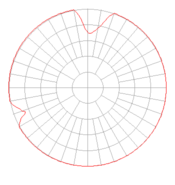 | ||||||||||||||||||
| Azimuth | Ratio | Azimuth | Ratio | Azimuth | Ratio | Azimuth | Ratio | ||||||||||||
| 0 | 0.704 | 10 | 0.762 | 20 | 1.000 | 30 | 1.000 | ||||||||||||
| 40 | 1.000 | 50 | 1.000 | 60 | 1.000 | 70 | 1.000 | ||||||||||||
| 80 | 1.000 | 90 | 1.000 | 100 | 1.000 | 110 | 1.000 | ||||||||||||
| 120 | 1.000 | 130 | 1.000 | 140 | 1.000 | 150 | 1.000 | ||||||||||||
| 160 | 1.000 | 170 | 1.000 | 180 | 1.000 | 190 | 1.000 | ||||||||||||
| 200 | 1.000 | 210 | 1.000 | 220 | 1.000 | 230 | 1.000 | ||||||||||||
| 240 | 1.000 | 245 | 0.930 | 248 | 0.850 | 250 | 0.880 | ||||||||||||
| 260 | 1.000 | 270 | 1.000 | 280 | 1.000 | 290 | 1.000 | ||||||||||||
| 300 | 1.000 | 310 | 1.000 | 320 | 1.000 | 330 | 1.000 | ||||||||||||
| 340 | 1.000 | 350 | 1.000 | ||||||||||||||||
Structure Registration Number 1042198 Structure Type: TOWER Registered To: McVey Entertainment Group, LLC Structure Address: 195 & 95 Nez Perce 1.8 Km Sse Of Int Of Routes Lewiston, ID County Name: Nez Perce County ASR Issued: 11/02/2022 Date Built: 05/15/1982 Site Elevation: 878 m (2881 ft.) Structure Height: 95 m (312 ft.) Height Overall: 96 m (315 ft.) Overall Height AMSL: 974 m (3196 ft.) Paint & Light FAA Chapters: 1, 3, 12, 21 46-27-33.0 N 117-02-22.0 W (NAD 83) 46-27-33.4 N 117-02-18.4 W (Converted to NAD 27) |
2575 Snake River Avenue Lewiston, ID 83501 Phone: 208-746-2811 Limited Liability Company | Date: 10/25/2018 Application Certifier IDA-VEND COMPANY, INC. 805 Stewart Avenue Lewiston, ID 83501 Applicant W. JEFFREY REYNOLDS Du Treil, Lundin & Rackley, Inc. 3135 Southgate Circle Sarasota, FL 34239-5515 TECHNICAL CONSULTANT KENNETH E. SATTEN Wilkinson Barker Knauer, Llp 1800 M Street, Nw Suite 800n Washington, DC 20036 | |||||||||||||||||