
FCCInfo.com
A Service of Cavell, Mertz & Associates, Inc.
(855) FCC-INFO
|
|
W300DE from 01/09/2014 |
|
|
||||||||||||||||
|
|
W300DE Channel: 300D 107.9 MHz Memphis, Tennessee Service: FX - A translator or application for a translator. Facility ID: 148438 Fac. Service: FX Programming Delivery Method: Unspecified Status: License Application Accepted: 01/31/2019 Application Granted: 02/07/2019 File Number: BLFT-20190131ABI License Expires: 00/00/0000 Prefix Type: This is a license for a translator Application Type: License To Cover FCC Website Links: LMS Facility Details This Application CDBS Application Other W300DE Applications Other W300DE Applications in CDBS Including Superseded Applications Mailing Address Correspondence for W300DE Correspondence related to application BLFT-20190131ABI Service Contour - Open Street Map or USGS Map (60 dBu) Service Contour - KML / Google Earth (60 dBu) Class: D, A Noncommercial educational operating with no more than 10W Site Location: 35-08-45.3 N 89-48-48.3 W (NAD 83) Site Location: 35-08-45.0 N 89-48-48.0 W (Converted to NAD 27) Effective Radiated Power: 0.25 kW Transmitter Output Power: 0.574 kW Antenna Center HAAT: 0 m Antenna Center AMSL: 190 m (623 ft.) Antenna Center HAG: 91 m (299 ft.) Site Elevation: 99 m. (325 ft.) Height Overall*: 186 m (610 ft.) (* As Filed In This Application, may differ from ASR Data, Below.) Directional Antenna Antenna Make/Model: None Antenna ID: 127736 Polarization:
| ||||||||||||||||||
| Antenna Data for Antenna Id: 127736 W300DE FX File: BLFT-20190131ABI None - Service: FX | 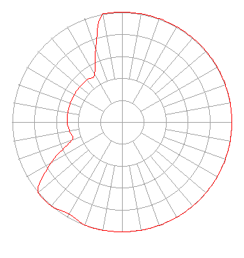 | ||||||||||||||||||
| Azimuth | Ratio | Azimuth | Ratio | Azimuth | Ratio | Azimuth | Ratio | ||||||||||||
| 0 | 1.000 | 10 | 1.000 | 20 | 1.000 | 30 | 1.000 | ||||||||||||
| 40 | 1.000 | 50 | 1.000 | 60 | 1.000 | 70 | 1.000 | ||||||||||||
| 80 | 1.000 | 90 | 1.000 | 100 | 1.000 | 110 | 1.000 | ||||||||||||
| 120 | 1.000 | 130 | 1.000 | 140 | 1.000 | 150 | 1.000 | ||||||||||||
| 160 | 1.000 | 170 | 1.000 | 180 | 1.000 | 190 | 1.000 | ||||||||||||
| 200 | 0.996 | 210 | 0.966 | 220 | 1.000 | 230 | 1.000 | ||||||||||||
| 240 | 0.747 | 250 | 0.487 | 260 | 0.485 | 270 | 0.500 | ||||||||||||
| 280 | 0.500 | 290 | 0.500 | 300 | 0.500 | 310 | 0.500 | ||||||||||||
| 320 | 0.500 | 330 | 0.500 | 340 | 0.700 | 350 | 1.000 | ||||||||||||
Structure Registration Number 1038069 Structure Type: GTOWER Registered To: HOBSON DEVELOPMENT COMPANY Structure Address: 7434 Raleigh Lagrange Rd Memphis, TN County Name: Shelby County ASR Issued: 05/23/2018 Date Built: 07/01/2018 Site Elevation: 99 m (325 ft.) Structure Height: 186 m (610 ft.) Height Overall: 186 m (610 ft.) Overall Height AMSL: 285 m (935 ft.) FAA Determination: 05/15/2018 FAA Study #: 2018-ASO-5712-OE FAA Circular #: 70/7460-1L Paint & Light FAA Chapters: 4, 8, 12 PRIOR STUDY 1991-ASO-1532-OE 35-08-45.0 N 89-48-48.0 W (NAD 83) 35-08-44.7 N 89-48-47.7 W (Converted to NAD 27) |
P.o. Box 49262 Wichita, KS 67201 Phone: 316-648-5613 | Date: 01/31/2019 Application Certifier LEGACY MEDIA - MEMPHIS, LLC 5495 Murray Road Memphis, TN 38119 Applicant CHARLES M. ANDERSON 1519 Euclid Avenue Bowling Green, KY 42103 ENGINEERING CONSULTANT CHRISTOPHER D. IMLAY Booth, Freret & Imlay, Llc 14356 Cape May Road Booth, Freret & Imlay, Llc Silver Spring, MD 20904-2090 | |||||||||||||||||